- Elevation
- 236 m
- above sea level
- Local time
- UTC+00:00
- Europe/London · UTC+00:00
- Places inside
- 4
- listed under Hugill
- Airports
- MME Teesside International Airport93 km
- LBA Leeds Bradford Airport97 km
About Hugill
Hugill is a village. Location: Westmorland and Furness, Cumbria. Elevation: 236 m. The best months to visit are July–August. The nearest airport is Teesside International Airport (93 km). Nearby sights include Millrigg Knott and Elfhowe Hill.
Photos of Hugill
-
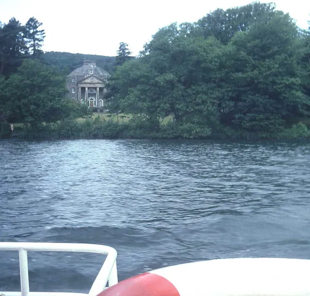
Belle Isle Trevor Rickard · CC BY-SA 2.0

Climate of Hugill
Best months for sightseeingBest months for sightseeing: July–August.
This month · November
A wet month
Day 8° · Night 2° · Rain 190 mm
- Hottest month
- July (day 18°)
- Coldest month
- January (night 0°)
- Wettest month
- December (197 mm)
- Driest month
- June (99 mm)
Bars: average monthly low and high temperature. Below: precipitation. Monthly averages for 1970–2000 at about 18 km resolution, adjusted for elevation. Highlighted months are mild and relatively dry. Source: WorldClim 2.1 (CC BY 4.0).
Show values as a table
| Month | Jan | Feb | Mar | Apr | May | Jun | Jul | Aug | Sep | Oct | Nov | Dec |
|---|---|---|---|---|---|---|---|---|---|---|---|---|
| Average high (°C) | 5° | 5° | 7° | 10° | 14° | 16° | 18° | 17° | 15° | 12° | 8° | 5° |
| Average low (°C) | 0° | 0° | 1° | 3° | 5° | 8° | 10° | 10° | 8° | 5° | 2° | 1° |
| Precipitation (mm) | 191 | 135 | 154 | 101 | 100 | 99 | 109 | 135 | 153 | 193 | 190 | 197 |
How to get to Hugill
The nearest airport is Teesside International Airport (MME), 93 km to the east as the crow flies. For international flights: Leeds Bradford Airport (LBA) (97 km). The nearest large city is Blackpool, 66 km to the south.
Airports
- Teesside International Airport (MME) Darlington, Durham 93 kmeast
- Leeds Bradford Airport (LBA) Leeds, West Yorkshire 97 kmsoutheast
- Newcastle International Airport (NCL) Newcastle upon Tyne, Tyne and Wear 103 kmnortheast
Nearby large cities
- Blackpool Population: 145K 66 kmsouth
- Preston Population: 313.3K 71 kmsouth
- Blackburn Population: 146.5K 76 kmsouth
- Burnley Population: 149.4K 77 kmsoutheast
- Bolton Population: 141.3K 94 kmsouth
Straight-line distances; road distances are longer. Airport data: OurAirports.
Day trips from Hugill
Within 100 km: 720 historic and cultural sites, 1,915 natural sites, 357 lakes, rivers and coasts.
0–25 km721 places
- Tuft Rock Island 6 kmSW
- Peel Island Island 18 kmSW
- Wood Howe Island 12 kmN
- Seamew Crag Island 8 kmW
25–60 km1,059 places
- High Moor Mountain 27 kmSW
- Roanhead Beach Beach 37 kmSW
- St. Bees Beach Seafront Beach 50 kmW
- Walney Island Island 42 kmSW
60–100 km1,212 places
- British Isles Island 87 kmSW
- Great Britain Island 71 kmSE
- Formby Beach Beach 94 kmS
- Ainsdale Beach Beach 89 kmS
Straight-line distances.
Places in Hugill
4 placesCities & villages1
- Ings · Village
Mountains & nature3
- High Knott · Mountain
- Hugill Fell · Mountain
- Reston Scar · Mountain
Nearby attractions & nature
Everything nearby-
Millrigg Knott Mountain, Over Staveley1.5 km NE
-
Elfhowe Hill Mountain, Over Staveley1.9 km E
-
Banner Rigg Mountain, Windermere2.7 km W
-
Borwick Hill Mountain, Nether Staveley3.2 km S
-
Brunt Knott Mountain, Over Staveley3.3 km E
-
Capple Howe Mountain, Windermere3.3 km NW
Sources & licences
Data last updated: