- Elevation
- 49 m
- above sea level
- Local time
- UTC+00:00
- Europe/London · UTC+00:00
- Airports
- LBA Leeds Bradford Airport99 km
- MME Teesside International Airport99 km
About Storrs
Storrs is a village. Location: Windermere, Westmorland and Furness. Elevation: 49 m.
Storrs is a hamlet in the civil parish of Windermere and Bowness, in the Westmorland and Furness district of the ceremonial county of Cumbria, England. It lies 2 miles (3.2 km) south of Bowness-on-Windermere, on the A592 road, close to the east shore of the lake, Windermere. Historically a part of Westmorland, the most notable landmark is the Grade II* listed Georgian mansion and folly at Storrs Hall.
Source: Wikipedia · CC BY-SA 4.0
Photos of Storrs
-
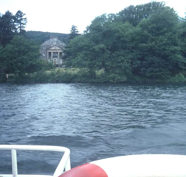
Belle Isle Trevor Rickard · CC BY-SA 2.0

Climate of Storrs
Best months for sightseeingBest months for sightseeing: June–August.
This month · November
A wet month
Day 9° · Night 4° · Rain 190 mm
- Hottest month
- July (day 19°)
- Coldest month
- January (night 1°)
- Wettest month
- December (197 mm)
- Driest month
- June (99 mm)
Bars: average monthly low and high temperature. Below: precipitation. Monthly averages for 1970–2000 at about 18 km resolution, adjusted for elevation. Highlighted months are mild and relatively dry. Source: WorldClim 2.1 (CC BY 4.0).
Show values as a table
| Month | Jan | Feb | Mar | Apr | May | Jun | Jul | Aug | Sep | Oct | Nov | Dec |
|---|---|---|---|---|---|---|---|---|---|---|---|---|
| Average high (°C) | 6° | 7° | 9° | 11° | 15° | 17° | 19° | 19° | 16° | 13° | 9° | 7° |
| Average low (°C) | 1° | 1° | 2° | 4° | 6° | 9° | 12° | 11° | 9° | 6° | 4° | 2° |
| Precipitation (mm) | 191 | 135 | 154 | 101 | 100 | 99 | 109 | 135 | 153 | 193 | 190 | 197 |
How to get to Storrs
The nearest airport is Leeds Bradford Airport (LBA), 99 km to the southeast as the crow flies. The nearest large city is Blackpool, 59 km to the south.
Airports
- Leeds Bradford Airport (LBA) Leeds, West Yorkshire 99 kmsoutheast
- Teesside International Airport (MME) Darlington, Durham 99 kmeast
- Newcastle International Airport (NCL) Newcastle upon Tyne, Tyne and Wear 111 kmnortheast
Nearby large cities
- Blackpool Population: 145K 59 kmsouth
- Preston Population: 313.3K 66 kmsouth
- Blackburn Population: 146.5K 72 kmsoutheast
- Burnley Population: 149.4K 76 kmsoutheast
- Bolton Population: 141.3K 91 kmsouth
Straight-line distances; road distances are longer. Airport data: OurAirports.
Day trips from Storrs
Within 100 km: 673 historic and cultural sites, 1,840 natural sites, 346 lakes, rivers and coasts.
0–25 km736 places
- High Moor Mountain 19 kmSW
- Tuft Rock Island 3 kmN
- Peel Island Island 10 kmW
- Wood Howe Island 19 kmNE
25–60 km988 places
- Roanhead Beach Beach 29 kmSW
- St. Bees Beach Seafront Beach 47 kmW
- Walney Island Island 34 kmSW
- Foulney Island Island 36 kmSW
60–100 km1,135 places
- British Isles Island 79 kmSW
- Great Britain Island 72 kmSE
- Formby Beach Beach 87 kmS
- Ainsdale Beach Beach 82 kmS
Straight-line distances.
Nearby attractions & nature
Everything nearby-
Barker Knott Mountain, Windermere1 km E
-
Ramp Holme Island, Windermere0.8 km N
-
Oven Bottom Island, Windermere0.8 km NW
-
Bull Head Island, Windermere0.8 km NW
-
Belle Isle Island, Windermere2.3 km N
-
Hen Rock Island, Windermere1 km N
Other cities and towns in Windermere
-
 Troutbeck Bridge Village, Windermere5.8 km N
-
Heathwaite Neighbourhood, Windermere3.9 km NE
-
Droomer Neighbourhood, Windermere4.3 km NE
-
The Common Village, Windermere5.8 km NE
Sources & licences
Data last updated: · 2 independent sources