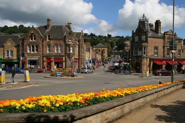
- Population
- 14,956
- 15K
- Elevation
- 97 m
- above sea level
- Local time
- UTC+00:00
- Europe/London · UTC+00:00
- Airports
- EMA East Midlands Airport37 km
- MAN Manchester Airport54 km
About Matlock
Matlock is a city. Location: Derbyshire Dales District, Derbyshire. Population: 14,956. Elevation: 97 m.
Matlock is the county town of Derbyshire, England. It is in the south-eastern part of the Peak District, with the National Park directly to the west. The spa resort of Matlock Bath is immediately south of the town as well as Cromford lying further south still. The civil parish of Matlock Town had a population in the 2021 UK census of 10,000. Matlock is 9 miles (14 km) south-west of Chesterfield and in close reach of the cities of Derby (19 miles), Sheffield (20 miles) and Nottingham (29 miles).
Source: Wikipedia · CC BY-SA 4.0
At a glance
- Area
- 5.5 km²
Source: Wikidata
Photos of Matlock
-

Saeidpourbabak · CC BY-SA 4.0 -

Istratoff · CC BY-SA 4.0 -

Monika from Warsaw , Poland / Sheffield, United Kingdom · CC BY-SA 2.0 -

Michael Dibb · CC BY-SA 2.0 -

Daderot · CC0


Travel notes for Matlock
From Wikivoyage
Matlock is a town in Derbyshire, on the edge of the Peak District National Park, about 20 miles (32 km) north of Derby.
Understand+
Matlock is really two destinations: The town is the main shopping and administrative centre for the area, while Matlock Bath a few miles down the road is the tourist trap.
Matlock Bath merits a visit for its natural setting and Victorian charm. The riverside is developed on one side only — the West bank — with woods and crags on the opposite bank, through which wind the Lovers' Walks. Although about as far as one can get from the sea in England, it has an almost seaside feel and none of the elegance of spa towns such as Buxton, Cheltenham, Leamington or Bath.
Visitor information:
Matlock Town Council
Get in+
By bus:
Regular TransPeak long-distance bus services from Derby or Manchester (via Buxton ) or 6.1 service bus from Derby or Bakewell.
Also accessible via frequent bus services to/from Sheffield and Chesterfield.
By train:
Matlock is the terminus station on the Derwent Valley branch railway from Derby, from where connections can be made to all major cities in UK. Railway stations at 1 Matlock for the town or 2 Matlock Bath (1.5 miles S) for the scenic Derwent gorge area, the Heights of Abraham attraction, caves and cable car service.
By car:
Matlock is on the A6 Derby-Stockport road south of Buxton. The nearest motorway junction is J28 on M1, then A38 westbound to Alfreton, then A615 westbound to Matlock.
By plane:
Nearest airport is East Midlands Airport, accessible by regular shuttle bus to/from Derby railway station.
Source: Wikivoyage · CC BY-SA 4.0 · abridged
Climate of Matlock
Best months for sightseeingBest months for sightseeing: June–August.
This month · November
A cold month
Day 9° · Night 4° · Rain 87 mm
- Hottest month
- July (day 20°)
- Coldest month
- February (night 1°)
- Wettest month
- December (89 mm)
- Driest month
- July (61 mm)
Bars: average monthly low and high temperature. Below: precipitation. Monthly averages for 1970–2000 at about 18 km resolution, adjusted for elevation. Highlighted months are mild and relatively dry. Source: WorldClim 2.1 (CC BY 4.0).
Show values as a table
| Month | Jan | Feb | Mar | Apr | May | Jun | Jul | Aug | Sep | Oct | Nov | Dec |
|---|---|---|---|---|---|---|---|---|---|---|---|---|
| Average high (°C) | 7° | 7° | 9° | 11° | 15° | 18° | 20° | 20° | 17° | 13° | 9° | 7° |
| Average low (°C) | 1° | 1° | 2° | 4° | 6° | 9° | 11° | 11° | 9° | 6° | 4° | 2° |
| Precipitation (mm) | 83 | 62 | 68 | 63 | 64 | 69 | 61 | 75 | 73 | 84 | 87 | 89 |
How to get to Matlock
The nearest airport is East Midlands Airport (EMA), 37 km to the southeast as the crow flies. The nearest large city is Chesterfield, 16 km to the northeast.
Airports
- East Midlands Airport (EMA) Nottingham, Leicestershire 37 kmsoutheast
- Manchester Airport (MAN) Manchester, Greater Manchester 54 kmnorthwest
- Birmingham Airport (BHX) Birmingham, West Midlands 77 kmsouth
Nearby large cities
- Chesterfield Population: 113.1K 16 kmnortheast
- Mansfield Population: 172K 24 kmeast
- Derby Population: 270.5K 25 kmsouth
- Sheffield Population: 556.5K 28 kmnorth
- Nottingham Population: 323.6K 34 kmsoutheast
Straight-line distances; road distances are longer. Airport data: OurAirports.
Day trips from Matlock
Within 100 km: 610 historic and cultural sites, 809 natural sites, 135 lakes, rivers and coasts.
0–25 km162 places
- Holme Nook Island 22 kmS
- Holmes's Islands Island 20 kmSW
- Lees Moor Mountain 9 kmNW
- Sir William Hill Mountain 20 kmNW
25–60 km517 places
- Newark Island Island 49 kmE
- Horninglow island Island 37 kmS
- Don Island Island 35 kmN
- Torksey Island Island 57 kmE
60–100 km875 places
- Read's Island Island 91 kmNE
- Whitton Island Island 86 kmNE
- The Island Island 96 kmNE
- Howden Dyke Island Island 80 kmNE
Straight-line distances.
Nearby attractions & nature
Everything nearby-
High Tor Mountain, Matlock Town1.3 km S
-
Masson Hill Mountain, Bonsall2 km SW
-
Bilberry Knoll Mountain, Matlock Town2.6 km SE
-
Oaker Hill Mountain, South Darley2.9 km W
-
Scarthin Rock Mountain, Cromford3.2 km S
-
Blakelow Hill Mountain, Bonsall4.5 km W
-
Darley Dale Natural site, England4.3 km NW
-
Cocking Tor Mountain, Ashover4.6 km E
Sources & licences
Data last updated: · 2 independent sources