Dove Head
Located in Hartington Upper Quarter, High Peak District Coordinates: 53°12′58″ N 1°56′27″ W
- Elevation
- 434 m
- above sea level
- Local time
- UTC+00:00
- Europe/London · UTC+00:00
- Airports
- MAN Manchester Airport27 km
- EMA East Midlands Airport59 km
About Dove Head
Dove Head is a village. Location: Hartington Upper Quarter, High Peak District. Elevation: 434 m. The best months to visit are July–August. The nearest airport is Manchester Airport (27 km). Nearby sights include Axe Edge and Thirkelow Rocks.
Photos of Dove Head
-
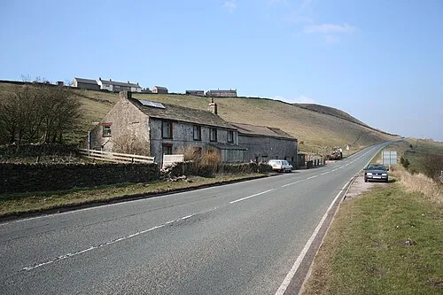
Axe Edge Dave Dunford · CC BY-SA 2.0

Climate of Dove Head
Best months for sightseeingBest months for sightseeing: July–August.
This month · November
A wet month
Day 7° · Night 2° · Rain 123 mm
- Hottest month
- July (day 18°)
- Coldest month
- February (night -1°)
- Wettest month
- November (123 mm)
- Driest month
- May (77 mm)
Bars: average monthly low and high temperature. Below: precipitation. Monthly averages for 1970–2000 at about 18 km resolution, adjusted for elevation. Highlighted months are mild and relatively dry. Source: WorldClim 2.1 (CC BY 4.0).
Show values as a table
| Month | Jan | Feb | Mar | Apr | May | Jun | Jul | Aug | Sep | Oct | Nov | Dec |
|---|---|---|---|---|---|---|---|---|---|---|---|---|
| Average high (°C) | 4° | 4° | 6° | 9° | 13° | 16° | 18° | 17° | 14° | 11° | 7° | 5° |
| Average low (°C) | -1° | -1° | 1° | 2° | 5° | 8° | 10° | 10° | 8° | 5° | 2° | 1° |
| Precipitation (mm) | 118 | 87 | 96 | 79 | 77 | 85 | 78 | 95 | 95 | 116 | 123 | 123 |
How to get to Dove Head
The nearest airport is Manchester Airport (MAN), 27 km to the northwest as the crow flies. The nearest large city is Stockport, 26 km to the northwest.
Airports
- Manchester Airport (MAN) Manchester, Greater Manchester 27 kmnorthwest
- East Midlands Airport (EMA) Nottingham, Leicestershire 59 kmsoutheast
- Liverpool John Lennon Airport (LPL) Liverpool 62 kmwest
Nearby large cities
- Stockport Population: 139.1K 26 kmnorthwest
- Stoke-on-Trent Population: 258.4K 29 kmsouthwest
- Newcastle-under-Lyme Population: 127.7K 31 kmsouthwest
- Chesterfield Population: 113.1K 35 kmeast
- Manchester Population: 569K 35 kmnorthwest
Straight-line distances; road distances are longer. Airport data: OurAirports.
Day trips from Dove Head
Within 100 km: 710 historic and cultural sites, 1,099 natural sites, 161 lakes, rivers and coasts.
0–25 km205 places
- Ladybower Reservoir Lake 24 kmNE
- Kinder Scout Mountain 19 kmN
- The Cloud Mountain 15 kmW
- Shining Tor Mountain 7 kmNW
25–60 km540 places
- Horninglow island Island 50 kmSE
- Saint George's Island Island 36 kmNW
- Don Island Island 45 kmNE
- Barton Island Island 60 kmSE
60–100 km1,225 places
- Great Britain Island 87 kmN
- Thurstaston Beach Beach 81 kmW
- Formby Beach Beach 86 kmNW
- Ainsdale Beach Beach 86 kmNW
Straight-line distances.
Nearby attractions & nature
Everything nearby-
Axe Edge Mountain, Hartington Upper Quarter0.9 km NW
-
Thirkelow Rocks Mountain, Hartington Upper Quarter1 km NE
-
Booth Hill Mountain, Hartington Upper Quarter1.6 km SE
-
Axe Edge Moor Mountain, Hartington Upper Quarter1.9 km N
-
Hollins Hill Mountain, Hartington Upper Quarter2.2 km SE
-
Oliver Hill Mountain, Quarnford1.8 km SW
Sources & licences
Data last updated: