
- Population
- 36,917
- 36.9K
- Elevation
- 13 m
- above sea level
- Local time
- UTC+00:00
- Europe/London · UTC+00:00
- Airports
- NCL Newcastle International Airport21 km
- MME Teesside International Airport40 km
About Chester-le-Street
Chester-le-Street is a town. Location: North Lodge, Durham. Population: 36,917. Elevation: 13 m.
Chester-le-Street () is a market town in County Durham, England. It is located around 6 miles (10 km) north of Durham and 9 miles (14 km) south of Newcastle-upon-Tyne. The town holds markets on Saturdays. At the 2021 census, the town had a population of 23,555.
Source: Wikipedia · CC BY-SA 4.0
Photos of Chester-le-Street
-

Robert Graham · CC BY-SA 2.0 -

Robert Graham · CC BY-SA 2.0 -

Ian Paterson · CC BY-SA 2.0 -

peter robinson · CC BY-SA 2.0 -

JohnBlackburne · CC BY-SA 3.0


Travel notes for Chester-le-Street
From Wikivoyage
Chester-le-Street is a town in County Durham, with a population of 23,500 in 2021. It's a commuter town for Newcastle 8 miles north; the main reason to visit is Durham CCC cricket ground, which stages county and international matches.
Understand+
"Chester" indicates the Roman fort of Concangis, and "le-Street" was what they marched along sinister-dexter. But when the Romans left Britain in 410 AD the settlement lay deserted for almost 500 years until monks fleeing Lindisfarne arrived. They brought with them a long-dead saint, a real live bishop (making this tiny place a cathedral city) and a Latin gospel which they translated into Old English.
The monks moved on in 995 but the village was still astride the main road north, so it became a stop-over for those on foot or horseback. It was also next to the navigable River Wear, so goods could be shipped in and out. From the 17th century it grew into a town with the Durham mining industry, and in 1868 the railway arrived, vaulting over the valley to put Newcastle within 15 minutes. That turned Chester-le-Street into commuterland for the city, and so it remains.
Get in+
No churns, no porter, no cat on a seat, at Chorlton-cum-Hardy or Chester-le-Street . . .
- "Slow Train" by Flanders and Swann (1963) mourns railway stations axed by Beeching, but this one survived.
Chester-le-Street 1 railway station is on the London-Newcastle-Edinburgh main line, but most trains thunder through. An hourly Transpennine train calls on its way from Liverpool Lime Street via Manchester Victoria, Leeds, York, Darlington and Durham, heading for Newcastle. From Scotland or Northumberland change at Newcastle. From London Kings Cross or Birmingham you usually change at York, but Newcastle-Chester takes only 10 minutes so it's sometimes quicker to double back. The railway station is central in town but the private contractor who ran it has gone bust, so in 2024 there are only makeshift arrangements for tickets, and other facilities such as toilets are closed. There is step-free access to both platforms.
Long-distance buses don't call here, travel via Newcastle. Go North East Bus X21 runs from Newcastle Eldon Square every 30 min via Gateshead, taking 30 min to Chester-le-Street. It continues to Durham (another 25 min), Spennymoor, Bishop Auckland and West Auckland. Angel Bus 21 is a slower service every 30 min from Newcastle via Birtley (for "Angel of the North") to Chester and Durham. A night bus Angel N21 runs F-Sa between 00:00 and 05:00.
Bus 50 runs hourly from South Shields via Washington to Chester-le-Street and Durham.
Arriva North East Bus X12 runs hourly from Middlesbrough via Stockton-on-Tees and Durham, continuing to Gateshead and Newcastle.
Bus 78 runs from Sunderland every 30 min, taking 45 min and continuing west to Beamish (for open air museum), Stanley and Consett.
Bus 71 runs hourly from Seaham on the coast, taking an hour via Houghton-le-Spring.
Buses make several stops through town, there isn't a bus station.
Chester-le-Street is close to A1(M) exit 63.
Source: Wikivoyage · CC BY-SA 4.0 · abridged
Climate of Chester-le-Street
Best months for sightseeingBest months for sightseeing: June–September.
This month · November
A cold month
Day 10° · Night 4° · Rain 58 mm
- Hottest month
- July (day 20°)
- Coldest month
- January (night 2°)
- Wettest month
- August (62 mm)
- Driest month
- February (39 mm)
Bars: average monthly low and high temperature. Below: precipitation. Monthly averages for 1970–2000 at about 18 km resolution, adjusted for elevation. Highlighted months are mild and relatively dry. Source: WorldClim 2.1 (CC BY 4.0).
Show values as a table
| Month | Jan | Feb | Mar | Apr | May | Jun | Jul | Aug | Sep | Oct | Nov | Dec |
|---|---|---|---|---|---|---|---|---|---|---|---|---|
| Average high (°C) | 7° | 8° | 10° | 11° | 14° | 17° | 20° | 20° | 17° | 14° | 10° | 8° |
| Average low (°C) | 2° | 2° | 3° | 4° | 6° | 9° | 11° | 11° | 9° | 7° | 4° | 3° |
| Precipitation (mm) | 56 | 39 | 53 | 46 | 49 | 50 | 48 | 62 | 56 | 54 | 58 | 58 |
Other places to visit in this season: June July August September
How to get to Chester-le-Street
The nearest airport is Newcastle International Airport (NCL), 21 km to the north as the crow flies. The nearest large city is Newcastle upon Tyne, 13 km to the north.
Airports
- Newcastle International Airport (NCL) Newcastle upon Tyne, Tyne and Wear 21 kmnorth
- Teesside International Airport (MME) Darlington, Durham 40 kmsouth
- Leeds Bradford Airport (LBA) Leeds, West Yorkshire 111 kmsouth
Nearby large cities
- Newcastle upon Tyne Population: 300.1K 13 kmnorth
- Sunderland Population: 170.1K 13 kmnortheast
- Middlesbrough Population: 142.7K 38 kmsoutheast
- York Population: 156.1K 105 kmsouth
- Leeds Population: 536.3K 118 kmsouth
Straight-line distances; road distances are longer. Airport data: OurAirports.
Day trips from Chester-le-Street
Within 100 km: 717 historic and cultural sites, 1,217 natural sites, 242 lakes, rivers and coasts.
0–25 km135 places
- Match Island Island 6 kmN
- Ryton Island Island 18 kmNW
- Warden Law Mountain 10 kmE
- Beacon Hill Mountain 18 kmE
25–60 km480 places
- Seaton Carew Beach Beach 33 kmSE
- Redcar Beach Beach 41 kmSE
- Saint Mary’s Island Island 25 kmN
- Coquet Island Island 53 kmN
60–100 km1,561 places
- Great Britain Island 99 kmS
- Cocklawburn Beach Beach 100 kmN
- Cheswick Sands Beach 98 kmN
- Longhoughton Beach Beach 64 kmN
Straight-line distances.
Nearby attractions & nature
Everything nearby-
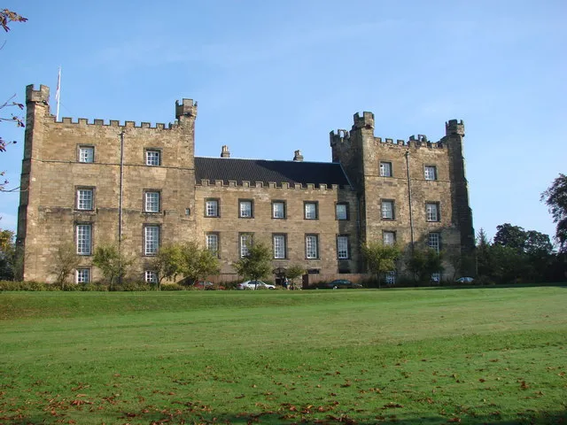 Lumley Castle Historic site, Little Lumley1.5 km SE
-
Beamish Museum Museum, Urpeth5.3 km W
-
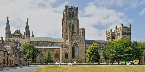 Durham Cathedral Attraction, Durham9.5 km S
-
Findon Hill Mountain, Sacriston5.8 km SW
-
Pockerley Pele Landmark, Urpeth6 km NW
-
Match Island Island, Gateshead5.5 km N
-
Angel of the North Landmark, Lamesley6.3 km N
-
Penshaw Hill Mountain, Sunderland6.5 km NE
Sources & licences
Data last updated: · 2 independent sources