- Elevation
- 98 m
- above sea level
- Local time
- UTC+00:00
- Europe/London · UTC+00:00
- Places inside
- 2
- listed under Thruxton
- Airports
- SOU Southampton Airport33 km
- BOH Bournemouth Airport49 km
About Thruxton
Thruxton is a village. Location: Test Valley District, Hampshire. Elevation: 98 m. The best months to visit are June–August. The nearest airport is Southampton Airport (33 km). Nearby sights include Quarley Hill and Furze Hill.
Climate of Thruxton
Best months for sightseeingBest months for sightseeing: June–August.
This month · November
A cold month
Day 10° · Night 4° · Rain 77 mm
- Hottest month
- July (day 21°)
- Coldest month
- February (night 2°)
- Wettest month
- December (81 mm)
- Driest month
- July (43 mm)
Bars: average monthly low and high temperature. Below: precipitation. Monthly averages for 1970–2000 at about 18 km resolution, adjusted for elevation. Highlighted months are mild and relatively dry. Source: WorldClim 2.1 (CC BY 4.0).
Show values as a table
| Month | Jan | Feb | Mar | Apr | May | Jun | Jul | Aug | Sep | Oct | Nov | Dec |
|---|---|---|---|---|---|---|---|---|---|---|---|---|
| Average high (°C) | 7° | 7° | 10° | 12° | 16° | 19° | 21° | 21° | 18° | 14° | 10° | 8° |
| Average low (°C) | 2° | 2° | 3° | 4° | 7° | 10° | 12° | 12° | 10° | 7° | 4° | 3° |
| Precipitation (mm) | 79 | 53 | 61 | 46 | 50 | 56 | 43 | 56 | 66 | 70 | 77 | 81 |
How to get to Thruxton
The nearest airport is Southampton Airport (SOU), 33 km to the southeast as the crow flies. For international flights: Bristol Airport (BRS) (79 km). The nearest large city is Southampton, 36 km to the southeast.
Airports
- Southampton Airport (SOU) Southampton 33 kmsoutheast
- Bournemouth Airport (BOH) Bournemouth 49 kmsouth
- Bristol Airport (BRS) Bristol 79 kmwest
Nearby large cities
- Southampton Population: 269.8K 36 kmsoutheast
- Basingstoke Population: 107.6K 38 kmeast
- Swindon Population: 201.7K 41 kmnorth
- Reading Population: 318K 53 kmnortheast
- Bath Population: 101.6K 55 kmwest
Straight-line distances; road distances are longer. Airport data: OurAirports.
Day trips from Thruxton
Within 100 km: 518 historic and cultural sites, 919 natural sites, 261 lakes, rivers and coasts.
0–25 km79 places
- Harnham Water Meadows Island 20 kmSW
- Ham Island Island 22 kmSW
- Swan Island Island 13 kmSE
- Great Island Island 20 kmSW
25–60 km477 places
- Portsea Island Natural site 59 kmSE
- Avon Beach Beach 53 kmS
- Calshot Beach Beach 48 kmSE
- Whale Island Island 56 kmSE
60–100 km1,142 places
- Isle of Wight Island 63 kmS
- Brownsea Island Island 62 kmSW
- Chesil Beach Beach 92 kmSW
- Studland Beach Beach 64 kmS
Straight-line distances.
Places in Thruxton
2 placesCities & villages2
- Mullenspond · Village
- Thruxton · Village
Nearby attractions & nature
Everything nearby-
Quarley Hill Mountain, Quarley2.5 km S
-
Furze Hill Mountain, Tidworth4 km NW
-
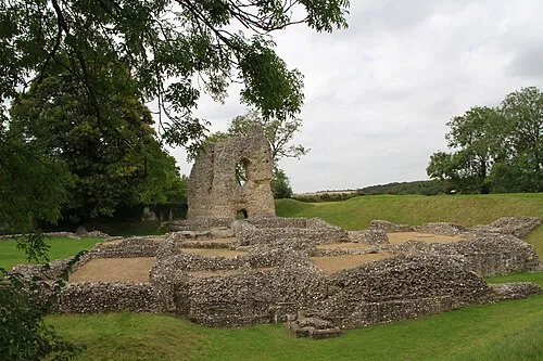 Ludgershall Castle Historic site, Ludgershall6.4 km N
-
Windmillhill Down Mountain, Tidworth6.6 km N
-
Boscombe Down East Mountain, Allington8.2 km SW
-
Beacon Hill Mountain, Bulford7.1 km W
Sources & licences
Data last updated: