Bentley Heath
Located in Hertsmere District, Hertfordshire Coordinates: 51°40′50″ N 0°11′40″ W
- Elevation
- 131 m
- above sea level
- Local time
- UTC+00:00
- Europe/London · UTC+00:00
- Airports
- LTN London Luton Airport25 km
- LCY London City Airport26 km
About Bentley Heath
Bentley Heath is a village. Location: Hertsmere District, Hertfordshire. Elevation: 131 m. The best months to visit are June–August. The nearest airport is London Luton Airport (25 km). Nearby sights include Underhill Stadium and Barnet Barnet Lane.
Photos of Bentley Heath
-
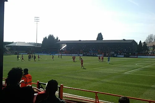
Underhill Stadium Paul Wilkinson from London, United Kingdom · CC BY 2.0

Climate of Bentley Heath
Best months for sightseeingBest months for sightseeing: June–August.
This month · November
A cold month
Day 10° · Night 4° · Rain 63 mm
- Hottest month
- July (day 22°)
- Coldest month
- February (night 1°)
- Wettest month
- October (67 mm)
- Driest month
- July (43 mm)
Bars: average monthly low and high temperature. Below: precipitation. Monthly averages for 1970–2000 at about 18 km resolution, adjusted for elevation. Highlighted months are mild and relatively dry. Source: WorldClim 2.1 (CC BY 4.0).
Show values as a table
| Month | Jan | Feb | Mar | Apr | May | Jun | Jul | Aug | Sep | Oct | Nov | Dec |
|---|---|---|---|---|---|---|---|---|---|---|---|---|
| Average high (°C) | 7° | 7° | 10° | 12° | 16° | 19° | 22° | 21° | 18° | 14° | 10° | 7° |
| Average low (°C) | 1° | 1° | 2° | 4° | 7° | 10° | 12° | 12° | 10° | 7° | 4° | 2° |
| Precipitation (mm) | 66 | 44 | 51 | 48 | 49 | 56 | 43 | 52 | 58 | 67 | 63 | 64 |
How to get to Bentley Heath
The nearest airport is London Luton Airport (LTN), 25 km to the northwest as the crow flies. The nearest large city is Enfield, 8 km to the southeast.
Airports
- London Luton Airport (LTN) Luton, Luton 25 kmnorthwest
- London City Airport (LCY) London 26 kmsoutheast
- London Heathrow Airport (LHR) London 30 kmsouthwest
Nearby large cities
- Enfield Population: 156.9K 8 kmsoutheast
- Tottenham Population: 130K 12 kmsoutheast
- Archway Population: 215.7K 13 kmsouth
- Watford Population: 125.7K 14 kmwest
- Harrow Population: 149.2K 15 kmsouthwest
Straight-line distances; road distances are longer. Airport data: OurAirports.
Day trips from Bentley Heath
Within 100 km: 849 historic and cultural sites, 574 natural sites, 312 lakes, rivers and coasts.
0–25 km352 places
- White Hart Lane Landmark 12 kmSE
- Lot's Ait Island 23 kmS
- Rook Island Island 21 kmSE
- Duck Island Island 20 kmS
25–60 km645 places
- The Lynch Island 53 kmSW
- Canvey Island Island 56 kmE
- Holm Island Island 36 kmSW
- Sunbury Court Island 33 kmSW
60–100 km738 places
- Isle of Sheppey Island 78 kmSE
- Spotlites @ Kings Theatre Attraction 60 kmSE
- St Nicholas Church Shoreham Attraction 94 kmS
- The Marlipins Museum Museum 95 kmS
Straight-line distances.
Nearby attractions & nature
Everything nearby-
Underhill Stadium Landmark, Barnet3.8 km S
-
Barnet Barnet Lane Landmark, Barnet3.7 km S
-
South Mymms Castle Historic site, South Mimms3.7 km NW
-
Saffron Green Mediumwave Transmitter, Mast 1 Landmark, South Mimms3.7 km SW
-
Saffron Green Mediumwave Transmitter, Mast 2 Landmark, South Mimms3.7 km SW
-
Saffron Green Mediumwave Transmitter, Mast 3 Landmark, South Mimms3.7 km SW
Other cities and towns in Hertsmere District
-
South Mimms Village, Hertsmere District2.1 km W
-
Little Heath Neighbourhood, Hertsmere District2.8 km N
-
Ridge Village, Hertsmere District5.3 km NW
-
Shenley Village, Hertsmere District5.7 km W
-
Elstree and Borehamwood Village, Hertsmere District6.5 km SW
-
 Elstree Village, Elstree and Borehamwood8.4 km SW
Sources & licences
Data last updated: