South Foreland
Located in St. Margaret's At Cliffe, Dover District Coordinates: 51°08′21″ N 1°22′19″ E
- Elevation
- 46 m
- above sea level
- Local time
- UTC+00:00
- Europe/London · UTC+00:00
- Airports
- SEN London Southend Airport67 km
- LCY London City Airport100 km
About South Foreland
South Foreland is a natural site. Location: St. Margaret's At Cliffe, Dover District. The best months to visit are June–September. The nearest airport is London Southend Airport (67 km). Nearby sights include South Foreland Lighthouse and Fan Bay.
Photos of South Foreland
-
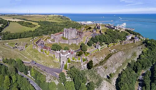
Dover Castle Chensiyuan · CC BY-SA 4.0 -
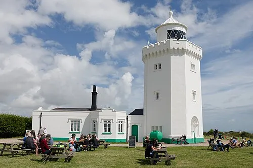
South Foreland Lighthouse Tilman2007 · CC BY-SA 4.0


Climate of South Foreland
Best months for sightseeingBest months for sightseeing: June–September.
This month · November
A cold month
Day 10° · Night 5° · Rain 72 mm
- Hottest month
- August (day 21°)
- Coldest month
- February (night 2°)
- Wettest month
- November (72 mm)
- Driest month
- February (38 mm)
Bars: average monthly low and high temperature. Below: precipitation. Monthly averages for 1970–2000 at about 18 km resolution, adjusted for elevation. Highlighted months are mild and relatively dry. Source: WorldClim 2.1 (CC BY 4.0).
Show values as a table
| Month | Jan | Feb | Mar | Apr | May | Jun | Jul | Aug | Sep | Oct | Nov | Dec |
|---|---|---|---|---|---|---|---|---|---|---|---|---|
| Average high (°C) | 7° | 7° | 10° | 12° | 15° | 18° | 21° | 21° | 18° | 14° | 10° | 8° |
| Average low (°C) | 2° | 2° | 3° | 5° | 8° | 11° | 13° | 13° | 11° | 8° | 5° | 3° |
| Precipitation (mm) | 56 | 38 | 43 | 41 | 40 | 44 | 41 | 44 | 62 | 68 | 72 | 59 |
Other places to visit in this season: June July August September
How to get to South Foreland
The nearest airport is London Southend Airport (SEN), 67 km to the northwest as the crow flies. For international flights: Ostend-Bruges International Airport (OST) (105 km). The nearest large city is Saint Peters, 25 km to the north.
Airports
- London Southend Airport (SEN) Southend-on-Sea, Essex 67 kmnorthwest
- London City Airport (LCY) London 100 kmnorthwest
- Ostend-Bruges International Airport (OST) Oostende 105 kmeast
Nearby large cities
- Saint Peters Population: 125.4K 25 kmnorth
- Maidstone Population: 107.6K 61 kmwest
- Southend-on-Sea Population: 295.3K 64 kmnorthwest
- Gillingham Population: 101.2K 64 kmnorthwest
- Basildon Population: 144.9K 80 kmnorthwest
Straight-line distances; road distances are longer. Airport data: OurAirports.
Day trips from South Foreland
Within 100 km: 234 historic and cultural sites, 206 natural sites, 152 lakes, rivers and coasts.
0–25 km63 places
- Sunny Sands Beach 14 kmSW
- Cheriton Hill Mountain 17 kmW
- Tolsford Hill Mountain 21 kmW
- Swinge Hill Mountain 13 kmW
25–60 km137 places
- Isle of Sheppey Island 47 kmNW
- Camber Sands Beach 47 kmSW
- Central Beach Beach 43 kmNW
- Isle of Oxney Island 46 kmW
60–100 km392 places
- Spotlites @ Kings Theatre Attraction 64 kmNW
- Plage Saint-Gabriel Beach 65 kmS
- Plage de Fort-Mahon Beach 91 kmS
- West Mersea Beach Beach 77 kmNW
Straight-line distances.
Nearest towns and villages
-
Dover Town, Dover4.4 km W
-
St Margaret's Bay Village, St. Margaret's At Cliffe1.3 km N
-
Saint Margaret’s at Cliffe Village, St. Margaret's At Cliffe1.9 km N
-
Westcliffe Village, St. Margaret's At Cliffe2 km NW
-
Swingate Village, St. Margaret's At Cliffe2.3 km W
-
Nelson Park Neighbourhood, St. Margaret's At Cliffe2.4 km N
Nearby attractions & nature
Everything nearby-
South Foreland Lighthouse Landmark, St. Margaret's At Cliffe0.1 km N
-
Fan Bay Natural site, England1.1 km SW
-
Crab Bay Natural site, England1.4 km SW
-
St. Margaret's Bay Natural site, St. Margaret's At Cliffe1.6 km NE
-
Langdon Bay Natural site, England1.8 km SW
-
Saint Margarets Bay Natural site, England2.9 km NW
-
Dover Castle Historic site, Dover3.7 km W
-
Swingate Transmitting Station, Tower 1 Landmark, St. Margaret's At Cliffe2.5 km W
Sources & licences
Data last updated: