
- Population
- 36,115
- 36.1K
- Elevation
- 23 m
- above sea level
- Local time
- UTC+00:00
- Europe/London · UTC+00:00
- Airports
- LGW London Gatwick Airport33 km
- LCY London City Airport38 km
About Tonbridge
Tonbridge is a town. Location: Tonbridge and Malling District, Kent. Population: 36,115. Elevation: 23 m.
Tonbridge ( TUN-brij; historic spelling Tunbridge) is a market town in Kent, England, on the River Medway, 4 miles (6 km) north of Royal Tunbridge Wells, 12 miles (19 km) south west of Maidstone and 29 miles (47 km) south east of London. In the administrative borough of Tonbridge and Malling, it had an estimated population of 36,115 in 2021.
Source: Wikipedia · CC BY-SA 4.0
Photos of Tonbridge
-

Robert-brook · CC0 -

MulFish · Public domain -
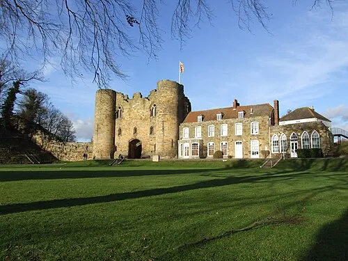
Tonbridge Castle Clem Rutter, Rochester Kent · CC BY-SA 3.0


Travel notes for Tonbridge
From Wikivoyage
Tonbridge is a town of 41,000 people (2019) on the River Medway in West Kent, in South-East England.
Understand+
History:
Situated on the banks of the river Medway, Tonbridge has been a market town since the Earl of Gloucester was granted the right to hold a weekly market in 1259. A castle was built there in the 11th century by Richard Fitzgilbert, a nobleman in William the Conqueror's invading army, and rebuilt in the 13th century.
The town and its surrounding areas became famous for the production of finely inlaid wooden cabinets, boxes and other objects, which were called "Tunbridgeware".
Tonbridge was spelt "Tunbridge" until 1870, but the spelling of the name was changed in an effort to avoid confusion with nearby Tunbridge Wells, a larger, but considerably newer, town about five miles to the south.
Get in+
Tonbridge is 4 miles (6 km) north of Royal Tunbridge Wells, 12 miles (19 km) south west of Maidstone and 29 miles (47 km) south east of London.
By car:
The main roads into Tonbridge are the A21, which runs from the M25 down to Hastings, the A26, which goes south to Brighton and north to Maidstone and the A227 which also goes north to Gravesend.
By train:
1 Tonbridge station is very near the centre of town and has trains from London Charing Cross, Tunbridge Wells, Hastings, Redhill, Ashford and East Kent. Additionally there are services to London Cannon St via London Bridge. London is served by four services per hour and the journey takes 30-45 minutes. Tickets cost about £10.
By bus:
There are local buses to Tunbridge Wells and Sevenoaks (route 402) and Maidstone (routes 6 and 7), and other towns.
Source: Wikivoyage · CC BY-SA 4.0 · abridged
Climate of Tonbridge
Best months for sightseeingBest months for sightseeing: June–August.
This month · November
A cold month
Day 11° · Night 4° · Rain 77 mm
- Hottest month
- August (day 22°)
- Coldest month
- February (night 2°)
- Wettest month
- January (79 mm)
- Driest month
- July (44 mm)
Bars: average monthly low and high temperature. Below: precipitation. Monthly averages for 1970–2000 at about 18 km resolution, adjusted for elevation. Highlighted months are mild and relatively dry. Source: WorldClim 2.1 (CC BY 4.0).
Show values as a table
| Month | Jan | Feb | Mar | Apr | May | Jun | Jul | Aug | Sep | Oct | Nov | Dec |
|---|---|---|---|---|---|---|---|---|---|---|---|---|
| Average high (°C) | 7° | 8° | 10° | 13° | 16° | 19° | 22° | 22° | 19° | 15° | 11° | 8° |
| Average low (°C) | 2° | 2° | 3° | 4° | 7° | 10° | 12° | 12° | 10° | 7° | 4° | 3° |
| Precipitation (mm) | 79 | 48 | 56 | 47 | 49 | 55 | 44 | 51 | 65 | 73 | 77 | 76 |
How to get to Tonbridge
The nearest airport is London Gatwick Airport (LGW), 33 km to the west as the crow flies. The nearest large city is Maidstone, 19 km to the northeast.
Airports
- London Gatwick Airport (LGW) London 33 kmwest
- London City Airport (LCY) London 38 kmnorthwest
- London Southend Airport (SEN) Southend-on-Sea, Essex 51 kmnortheast
Nearby large cities
- Maidstone Population: 107.6K 19 kmnortheast
- Bexley Population: 228K 29 kmnorth
- Gillingham Population: 101.2K 29 kmnortheast
- Crawley Population: 124K 33 kmwest
- Croydon Population: 173.3K 33 kmnorthwest
Straight-line distances; road distances are longer. Airport data: OurAirports.
Day trips from Tonbridge
Within 100 km: 661 historic and cultural sites, 518 natural sites, 276 lakes, rivers and coasts.
0–25 km110 places
- Osprey Island Island 11 kmSE
- Tinker's Island Island 1 kmW
- Sixteen Acre Island Island 11 kmW
- Two Bridges Island Island 11 kmW
25–60 km747 places
- Isle of Sheppey Island 45 kmNE
- White Hart Lane Landmark 51 kmNW
- Spotlites @ Kings Theatre Attraction 27 kmNE
- St Nicholas Church Shoreham Attraction 56 kmSW
60–100 km598 places
- West Mersea Beach Beach 79 kmNE
- Sunny Sands Beach 65 kmE
- Climping Beach Beach 74 kmSW
- Pagham Beach Beach 85 kmSW
Straight-line distances.
Nearby attractions & nature
Everything nearby-
Tonbridge Castle Historic site, Tonbridge and Malling District0.1 km N
-
Tinker's Island Island, Tonbridge and Malling District0.9 km W
-
Barden Lake Lake, Tonbridge and Malling District1.4 km W
-
Castle Hill Mountain, Capel3.2 km SE
-
Bidborough Hill Mountain, Bidborough3.5 km SW
-
Sandown Park Mountain, Tunbridge Wells District6.4 km S
-
Hurst Wood Natural site, Tunbridge Wells District6.4 km S
-
Redleaf Hill Mountain, Penshurst6.5 km W
Sources & licences
Data last updated: · 2 independent sources