Royal Tunbridge Wells
Located in Tunbridge Wells District, Kent Coordinates: 51°08′00″ N 0°15′45″ E

- Population
- 68,910
- 68.9K
- Elevation
- 118 m
- above sea level
- Local time
- UTC+00:00
- Europe/London · UTC+00:00
- Airports
- LGW London Gatwick Airport31 km
- LCY London City Airport44 km
About Royal Tunbridge Wells
Royal Tunbridge Wells is a town. Location: Tunbridge Wells District, Kent. Population: 68,910. Elevation: 118 m.
Royal Tunbridge Wells (formerly, until 1909, and still commonly Tunbridge Wells) is a town in Kent, England, 30 miles (50 kilometres) southeast of Central London. It lies close to the border with East Sussex on the northern edge of the High Weald, whose sandstone geology is exemplified by the rock formation High Rocks. The town was a spa in the Restoration and a fashionable resort in the mid-1700s under Beau Nash when the Pantiles, and its chalybeate spring, attracted visitors who wished to take the waters.
Source: Wikipedia · CC BY-SA 4.0
Photos of Royal Tunbridge Wells
-

Jez Timms jeztimms · CC0 -

Jez Timms jeztimms · CC0 -

Unknown author Unknown author · Public domain -

Wikimedia Commons · CC BY 4.0 -

Cherno999 · CC BY-SA 4.0


Travel notes for Royal Tunbridge Wells
From Wikivoyage
Royal Tunbridge Wells is a town in west Kent on the border with East Sussex, in the South East of England.
Understand+
Tunbridge Wells was founded in the 17th century following the discovery of the Chalybeate Spring in 1606. The waters from the spring were said to have restorative properties, and so Tunbridge Wells grew into a thriving spa resort town. Queen Victoria regularly travelled down from London to "take the waters", and in 1909 King Edward VII granted the town its "Royal" prefix (although this is rarely used by the inhabitants any more).
Visitor information:
Visit Tunbridge Wells website
Get in+
By car:
Tunbridge Wells can be accessed from the north using the A21 trunk road, which runs as a dual carriageway for most of its length between the M25 and the outskirts of the town. The A21 continues south past Tunbridge Wells to Lamberhurst and Hastings.
The single carriageway A26 runs through the town centre, providing a link to Brighton and Lewes to the south, and Tonbridge and the A21 to the north.
To the west, the A264 provides connections to East Grinstead, Crawley and Gatwick Airport. To the east, the A264 becomes the A228 and links to Paddock Wood, Maidstone, Rochester and Strood.
By train:
1 Tunbridge Wells station is in the town centre at the bottom of Mount Pleasant Road, close to the historic High Street and 5 minutes' walk from the Pantiles. It is on the London (Charing Cross/Waterloo/London Bridge) to Hastings route; trains are operated by Southeastern, ☏ +44 345 748 4950.
London is between 40 and 55 minutes away, depending on whether the train is direct or a stopper service. A standard class off-peak return ticket to London is £13.20 adult; £6.60 child.
Other Kent towns such as Canterbury, Ashford and Maidstone can be reached by train by changing at Tonbridge (10 minutes by train from Tunbridge Wells).
Source: Wikivoyage · CC BY-SA 4.0 · abridged
Places bordering Royal Tunbridge Wells
- Tonbridge
Climate of Royal Tunbridge Wells
Best months for sightseeingBest months for sightseeing: June–August.
This month · November
A cold month
Day 10° · Night 4° · Rain 88 mm
- Hottest month
- August (day 21°)
- Coldest month
- February (night 1°)
- Wettest month
- January (89 mm)
- Driest month
- July (46 mm)
Bars: average monthly low and high temperature. Below: precipitation. Monthly averages for 1970–2000 at about 18 km resolution, adjusted for elevation. Highlighted months are mild and relatively dry. Source: WorldClim 2.1 (CC BY 4.0).
Show values as a table
| Month | Jan | Feb | Mar | Apr | May | Jun | Jul | Aug | Sep | Oct | Nov | Dec |
|---|---|---|---|---|---|---|---|---|---|---|---|---|
| Average high (°C) | 7° | 7° | 9° | 12° | 16° | 18° | 21° | 21° | 18° | 14° | 10° | 8° |
| Average low (°C) | 2° | 1° | 3° | 4° | 7° | 10° | 12° | 12° | 10° | 7° | 4° | 3° |
| Precipitation (mm) | 89 | 55 | 62 | 51 | 50 | 57 | 46 | 53 | 72 | 85 | 88 | 86 |
How to get to Royal Tunbridge Wells
The nearest airport is London Gatwick Airport (LGW), 31 km to the west as the crow flies. The nearest large city is Maidstone, 23 km to the northeast.
Airports
- London Gatwick Airport (LGW) London 31 kmwest
- London City Airport (LCY) London 44 kmnorth
- London Southend Airport (SEN) Southend-on-Sea, Essex 57 kmnortheast
Nearby large cities
- Maidstone Population: 107.6K 23 kmnortheast
- Crawley Population: 124K 31 kmwest
- Gillingham Population: 101.2K 35 kmnortheast
- Bexley Population: 228K 35 kmnorth
- Croydon Population: 173.3K 38 kmnorthwest
Straight-line distances; road distances are longer. Airport data: OurAirports.
Day trips from Royal Tunbridge Wells
Within 100 km: 634 historic and cultural sites, 483 natural sites, 273 lakes, rivers and coasts.
0–25 km104 places
- Osprey Island Island 6 kmSE
- Tinker's Island Island 7 kmN
- Hawk Island Island 23 kmSW
- Sixteen Acre Island Island 12 kmNW
25–60 km723 places
- Isle of Sheppey Island 50 kmNE
- White Hart Lane Landmark 57 kmNW
- Spotlites @ Kings Theatre Attraction 33 kmNE
- St Nicholas Church Shoreham Attraction 50 kmSW
60–100 km563 places
- West Mersea Beach Beach 85 kmNE
- Sunny Sands Beach 65 kmE
- Climping Beach Beach 70 kmSW
- Pagham Beach Beach 81 kmSW
Straight-line distances.
Royal Tunbridge Wells and similar cities
Side by side with cities of similar size in the same country: population, elevation and climate.
| Measure | Royal Tunbridge Wells | Stafford | Maidenhead | Barnsley |
|---|---|---|---|---|
| Population | 68.9K | 70.1K | 70.4K | 71.4K |
| Elevation | 118 m | 77 m | 32 m | 112 m |
| Summer day (hottest month) | 21° | 20° | 23° | 21° |
| Winter night (coldest month) | 1° | 1° | 2° | 0° |
| Annual rainfall | 794 mm | 806 mm | 681 mm | 744 mm |
| Best months | Jun–Aug | Jun–Aug | Jun–Aug | Jun–Aug |
| Distance | — | 248 km | 81 km | 294 km |
Climate values are 1970–2000 monthly averages; straight-line distance.
Nearby attractions & nature
Everything nearby-
Hurst Wood Natural site, Tunbridge Wells District1.8 km NW
-
Sandown Park Mountain, Tunbridge Wells District2.4 km E
-
Rusthall Mediumwave Transmitter Landmark, Speldhurst2.8 km W
-
Frant Hill Mountain, Frant4.1 km S
-
Bidborough Hill Mountain, Bidborough4.1 km N
-
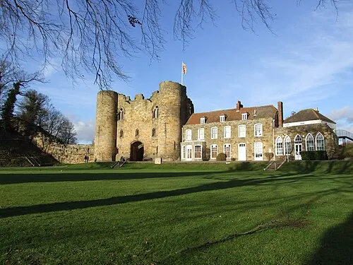 Tonbridge Castle Historic site, Tonbridge and Malling District7 km N
-
Castle Hill Mountain, Capel4.8 km NE
-
Furnace Hill Mountain, Lamberhurst5.6 km SE
Sources & licences
Data last updated: · 2 independent sources