
- Elevation
- 117 m
- above sea level
- Local time
- UTC+00:00
- Europe/London · UTC+00:00
- Airports
- MAN Manchester Airport46 km
- LPL Liverpool John Lennon Airport47 km
About Riley Green
Riley Green is a village. Location: Hoghton, Chorley District. Elevation: 117 m.
Riley Green is a hamlet, part of the civil parish of Hoghton, within the Borough of Chorley, Lancashire, England. It is located at the junction of the A675 and A6061 roads, between Preston, Blackburn and Chorley. The hamlet consists of a small number of houses and one pub - the Royal Oak on the A6061 on the A675 beside the Leeds and Liverpool Canal. Most of the surrounding area is pasture land. There is also a marina where many narrowboats are moored, and some are for hire.
Source: Wikipedia · CC BY-SA 4.0
Photos of Riley Green
-
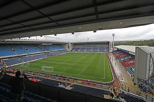
Ewood Park Ronnie Macdonald from Chelmsford, United Kingdom · CC BY 2.0

Climate of Riley Green
Best months for sightseeingBest months for sightseeing: June–August.
This month · November
A wet month
Day 9° · Night 4° · Rain 134 mm
- Hottest month
- July (day 19°)
- Coldest month
- January (night 1°)
- Wettest month
- November (134 mm)
- Driest month
- May (66 mm)
Bars: average monthly low and high temperature. Below: precipitation. Monthly averages for 1970–2000 at about 18 km resolution, adjusted for elevation. Highlighted months are mild and relatively dry. Source: WorldClim 2.1 (CC BY 4.0).
Show values as a table
| Month | Jan | Feb | Mar | Apr | May | Jun | Jul | Aug | Sep | Oct | Nov | Dec |
|---|---|---|---|---|---|---|---|---|---|---|---|---|
| Average high (°C) | 6° | 6° | 8° | 11° | 15° | 17° | 19° | 19° | 16° | 13° | 9° | 7° |
| Average low (°C) | 1° | 1° | 2° | 4° | 6° | 9° | 12° | 11° | 9° | 6° | 4° | 2° |
| Precipitation (mm) | 119 | 73 | 98 | 70 | 66 | 81 | 83 | 104 | 108 | 132 | 134 | 130 |
How to get to Riley Green
The nearest airport is Manchester Airport (MAN), 46 km to the southeast as the crow flies. The nearest large city is Blackburn, 7 km to the northeast.
Airports
- Manchester Airport (MAN) Manchester, Greater Manchester 46 kmsoutheast
- Liverpool John Lennon Airport (LPL) Liverpool 47 kmsouthwest
- Leeds Bradford Airport (LBA) Leeds, West Yorkshire 62 kmeast
Nearby large cities
- Blackburn Population: 146.5K 7 kmnortheast
- Preston Population: 313.3K 10 kmnorthwest
- Bolton Population: 141.3K 18 kmsoutheast
- Wigan Population: 175.4K 20 kmsouth
- Burnley Population: 149.4K 24 kmeast
Straight-line distances; road distances are longer. Airport data: OurAirports.
Day trips from Riley Green
Within 100 km: 644 historic and cultural sites, 1,782 natural sites, 250 lakes, rivers and coasts.
0–25 km148 places
- The Island Island 10 kmSE
- Goose Island Island 23 kmSW
- Pickup Bank Reservoir Lake 11 kmE
- Anglezarke Reservoir Lake 4 kmS
25–60 km627 places
- Great Britain Island 49 kmNE
- Thurstaston Beach Beach 57 kmSW
- Formby Beach Beach 39 kmSW
- Ainsdale Beach Beach 35 kmW
60–100 km1,901 places
- British Isles Island 99 kmW
- High Moor Mountain 66 kmNW
- Roanhead Beach Beach 66 kmNW
- The Island Island 83 kmNE
Straight-line distances.
Nearby attractions & nature
Everything nearby-
Preston Mediumwave Transmitter, Mast North Landmark, Hoghton0.5 km E
-
Preston Mediumwave Transmitter, Mast South Landmark, Hoghton0.5 km E
-
Hoghton Tower Mountain, Hoghton1.2 km N
-
Hoghton Tower Landmark, Hoghton1.2 km N
-
Pike Lowe Mountain, Withnell3.2 km S
-
Hough Hill Mountain, Brindle3.7 km SW
Sources & licences
Data last updated: · 2 independent sources