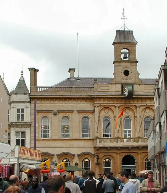
- Population
- 64,884
- 64.9K
- Elevation
- 49 m
- above sea level
- Local time
- UTC+00:00
- Europe/London · UTC+00:00
- Airports
- EMA East Midlands Airport11 km
- BHX Birmingham Airport51 km
About Loughborough
Loughborough is a town. Location: Charnwood District, Leicestershire. Population: 64,884. Elevation: 49 m.
Loughborough ( LUF-bər-ə) is a market town in the Charnwood borough of Leicestershire, England. It is the administrative centre of Charnwood Borough Council and, in the United Kingdom 2021 census, the town's built-up area had a population of 64,884. It is the second largest settlement in the county after Leicester; it lies close to the Nottinghamshire border and is located near Leicester, Nottingham and Derby. It is notable for its university, marketplace and fair.
Source: Wikipedia · CC BY-SA 4.0
Photos of Loughborough
-

Crep171166 · CC BY-SA 4.0 -

Robert Eva · CC BY-SA 2.0 -

Jupilogy · CC BY-SA 4.0 -

Yang Hong · CC BY-SA 4.0 -

Chick0nPTCG · CC BY-SA 4.0


Travel notes for Loughborough
From Wikivoyage
Loughborough (pronounced "LUFF-burra") is a market town in Leicestershire.
Understand+
Loughborough's fortunes were built on engineering and textiles. Now, however, the largest employer is Loughborough University, this has a dramatic impact on the town. The 14,000 students account for around one in four of the town's population. This gives the town a younger profile than you might expect in term time but makes the place relatively quiet during the summer.
The university has a 437 acres (177 hectares) campus on the mostly residential western side of the town. The campus occupies a band running west from the ring road to the edge of town, splitting the northern estates from the Forest Side in the south-west. The eastern side of the town, close to the canal and the railway lines is generally older, includes the town centre and contains more of the town's industry and industrial heritage.
The university promotes itself as a centre of excellence for sport. It hosts facilities for a number of national associations including the headquarters of the Amateur Swimming Association and the England and Wales Cricket Board's (ECB) National Cricket Performance Centre. Loughborough provided the main camp for 'Team GB' in the run-up to the 2012 London Olympics and the university's facilities were used by the Japanese Olympic team.
Get in+
By plane:
East Midlands Airport (EMA IATA) is 7 mi (11 km) north-west of Loughborough.
The town is well-connected to the airport by the Skylink bus service, a more direct link than via East Midlands Parkway railway station.
By train:
1 Loughborough station about a mile north-east of the town centre and is served by East Midland Trains travelling from London St Pancras International to Sheffield and London St Pancras International to Nottingham and by Cross Country Trains to Nottingham, Derby, Leicester, Lincoln, and Birmingham.
By car:
Loughborough sits on the main A6 road between Leicester and Derby and adjacent to the M1 motorway (at junction 23).
By bicycle:
Loughborough is on National Cycle Route 6.
By narrow-boat:
The refurbished Loughborough Wharf at the northern edge of the town centre links to the Grand Union Canal.
Source: Wikivoyage · CC BY-SA 4.0 · abridged
Twin towns and sister cities of Loughborough
- Gembloux· Belgium
Source: Wikidata. Only places with a page on this site are shown.
Climate of Loughborough
Best months for sightseeingBest months for sightseeing: June–August.
This month · November
A cold month
Day 10° · Night 4° · Rain 61 mm
- Hottest month
- July (day 21°)
- Coldest month
- February (night 1°)
- Wettest month
- December (64 mm)
- Driest month
- February (46 mm)
Bars: average monthly low and high temperature. Below: precipitation. Monthly averages for 1970–2000 at about 18 km resolution, adjusted for elevation. Highlighted months are mild and relatively dry. Source: WorldClim 2.1 (CC BY 4.0).
Show values as a table
| Month | Jan | Feb | Mar | Apr | May | Jun | Jul | Aug | Sep | Oct | Nov | Dec |
|---|---|---|---|---|---|---|---|---|---|---|---|---|
| Average high (°C) | 7° | 7° | 10° | 12° | 16° | 19° | 21° | 21° | 18° | 14° | 10° | 8° |
| Average low (°C) | 1° | 1° | 3° | 4° | 6° | 9° | 12° | 11° | 9° | 7° | 4° | 2° |
| Precipitation (mm) | 60 | 46 | 51 | 49 | 47 | 59 | 48 | 58 | 58 | 59 | 61 | 64 |
How to get to Loughborough
The nearest airport is East Midlands Airport (EMA), 11 km to the northwest as the crow flies. The nearest large city is Leicester, 15 km to the south.
Airports
- East Midlands Airport (EMA) Nottingham, Leicestershire 11 kmnorthwest
- Birmingham Airport (BHX) Birmingham, West Midlands 51 kmsouthwest
- Manchester Airport (MAN) Manchester, Greater Manchester 97 kmnorthwest
Nearby large cities
- Leicester Population: 368.6K 15 kmsouth
- Nottingham Population: 323.6K 21 kmnorth
- Derby Population: 270.5K 25 kmnorthwest
- Burton-on-Trent Population: 122.2K 30 kmwest
- Mansfield Population: 172K 41 kmnorth
Straight-line distances; road distances are longer. Airport data: OurAirports.
Day trips from Loughborough
Within 100 km: 596 historic and cultural sites, 660 natural sites, 117 lakes, rivers and coasts.
0–25 km76 places
- Barton Island Island 15 kmN
- The Islands Island 25 kmSE
- Bardon Hill Mountain 10 kmSW
- Beacon Hill Mountain 5 kmSW
25–60 km406 places
- Newark Island Island 43 kmNE
- Horninglow island Island 29 kmW
- Crescent Wood Island Island 50 kmSW
- Brown's Island Island 37 kmE
60–100 km891 places
- Park Island Island 64 kmE
- Glover's Island Island 90 kmSW
- Don Island Island 74 kmN
- Heron Island Island 75 kmSE
Straight-line distances.
Loughborough and similar cities
Side by side with cities of similar size in the same country: population, elevation and climate.
| Measure | Loughborough | Taunton | Torquay | Wrexham |
|---|---|---|---|---|
| Population | 64.9K | 64.6K | 65.4K | 65.7K |
| Elevation | 49 m | 22 m | 8 m | 87 m |
| Summer day (hottest month) | 21° | 21° | 21° | 20° |
| Winter night (coldest month) | 1° | 3° | 4° | 0° |
| Annual rainfall | 660 mm | 954 mm | 947 mm | 673 mm |
| Best months | Jun–Aug | Jun–Aug | Jun–Sep | Jun–Aug |
| Distance | — | 235 km | 303 km | 124 km |
Climate values are 1970–2000 monthly averages; straight-line distance.
Nearby attractions & nature
Everything nearby-
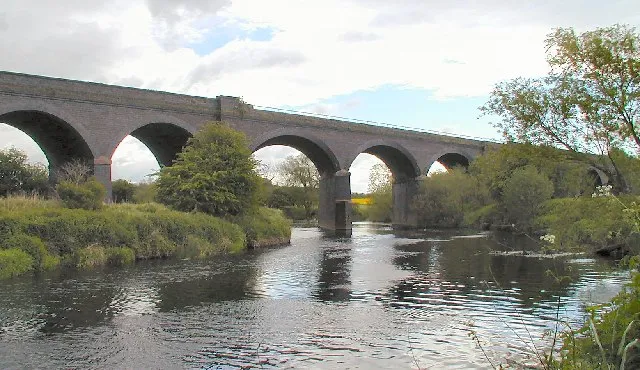 Stanford Viaduct Landmark, Stanford on Soar2.6 km N
-
Garendon Abbey Historic site, Charnwood District4 km W
-
Beacon Hill Mountain, Woodhouse5.3 km SW
-
Mountsorrel Castle Historic site, Mountsorrel5.8 km SE
-
Bawdon Castle Mountain, Charley6.6 km SW
-
Ives Head Mountain, Shepshed6.6 km W
-
Benscliffe Hill Mountain, Newtown Linford7 km SW
-
Whitwick Castle Historic site, North West Leicestershire11 km W
Sources & licences
Data last updated: · 2 independent sources