- Population
- 137,032
- 137K
- Elevation
- 46 m
- above sea level
- Local time
- UTC+00:00
- Europe/London · UTC+00:00
- Places inside
- 113
- listed under Breckland District
- Airports
- NWI Norwich Airport33 km
- STN London Stansted Airport88 km
About Breckland District
Breckland District is a municipality. Location: Norfolk, England. Population: 137,032. Elevation: 46 m. The best months to visit are June–September. The nearest airport is Norwich Airport (33 km). Nearby sights include Wayland Wood and Castle Acre Town Defences.
Photos of Breckland District
-
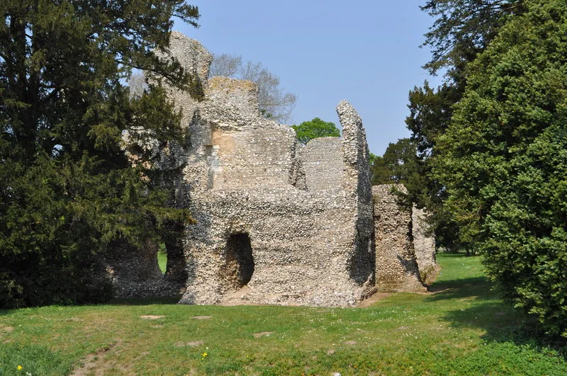
Weeting Castle Ashley Dace · CC BY-SA 2.0

Climate of Breckland District
Best months for sightseeingBest months for sightseeing: June–September.
This month · November
A cold month
Day 10° · Night 4° · Rain 68 mm
- Hottest month
- August (day 21°)
- Coldest month
- February (night 1°)
- Wettest month
- November (68 mm)
- Driest month
- February (45 mm)
Bars: average monthly low and high temperature. Below: precipitation. Monthly averages for 1970–2000 at about 18 km resolution, adjusted for elevation. Highlighted months are mild and relatively dry. Source: WorldClim 2.1 (CC BY 4.0).
Show values as a table
| Month | Jan | Feb | Mar | Apr | May | Jun | Jul | Aug | Sep | Oct | Nov | Dec |
|---|---|---|---|---|---|---|---|---|---|---|---|---|
| Average high (°C) | 7° | 7° | 10° | 12° | 16° | 19° | 21° | 21° | 18° | 14° | 10° | 7° |
| Average low (°C) | 1° | 1° | 2° | 4° | 7° | 10° | 12° | 12° | 10° | 7° | 4° | 2° |
| Precipitation (mm) | 60 | 45 | 50 | 45 | 46 | 57 | 56 | 58 | 60 | 64 | 68 | 60 |
Other places to visit in this season: June July August September
How to get to Breckland District
The nearest airport is Norwich Airport (NWI), 33 km to the east as the crow flies. For international flights: London Stansted Airport (STN) (88 km). The nearest large city is Norwich, 33 km to the east.
Airports
- Norwich Airport (NWI) Norwich, Norfolk 33 kmeast
- London Stansted Airport (STN) London, Essex 88 kmsouthwest
- London Luton Airport (LTN) Luton, Luton 114 kmsouthwest
Nearby large cities
- Norwich Population: 143.1K 33 kmeast
- Ipswich Population: 178.8K 63 kmsouth
- Cambridge Population: 145.7K 65 kmsouthwest
- Peterborough Population: 163.4K 72 kmwest
- Colchester Population: 130.2K 78 kmsouth
Straight-line distances; road distances are longer. Airport data: OurAirports.
Day trips from Breckland District
Within 100 km: 322 historic and cultural sites, 88 natural sites, 138 lakes, rivers and coasts.
0–25 km39 places
- Dog Island Island 20 kmS
- Long Island Island 20 kmS
- Butten Island Island 20 kmS
- Birdcage Island Island 15 kmSW
25–60 km192 places
- Snettisham Beach Beach 40 kmNW
- Weybourne Beach Beach 45 kmNE
- Sheringham Beach Beach 48 kmNE
- Scolt Head Island Island 45 kmN
60–100 km317 places
- Hemsby Beach Beach 61 kmE
- Aldeburgh's Beach Beach 72 kmSE
- West Mersea Beach Beach 91 kmS
- Osea Island Island 97 kmS
Straight-line distances.
Breckland District and similar cities
Side by side with cities of similar size in the same country: population, elevation and climate.
| Measure | Breckland District | Stockport | High Wycombe | Bolton |
|---|---|---|---|---|
| Population | 137K | 139.1K | 133.2K | 141.3K |
| Elevation | 46 m | 59 m | 76 m | 105 m |
| Summer day (hottest month) | 21° | 21° | 22° | 20° |
| Winter night (coldest month) | 1° | 2° | 1° | 1° |
| Annual rainfall | 669 mm | 927 mm | 681 mm | 1,116 mm |
| Best months | Jun–Sep | Jun–Aug | Jun–Aug | Jun–Aug |
| Distance | — | 220 km | 152 km | 244 km |
Climate values are 1970–2000 monthly averages; straight-line distance.
Places in Breckland District
113 placesCities & villages53
- Mattishall · Village
- Merton · Village
- Mileham · Village
- Mundford · Village
- Narborough · Village
- Narford · Village
- Necton · Village
- New Buckenham · Village
- Newton By Castle Acre · Village
- North Elmham · Village
- North Lopham · Village
- North Pickenham · Village
- North Tuddenham · Village
- Old Buckenham · Village
- Ovington · Village
- Oxborough · Village
- Quidenham · Village
- Riddlesworth · Village
- Rocklands · Village
- Roudham and Larling · Village
- Rougham · Village
- Saham Toney · Village
- Scarning · Village
- Scoulton · Village
- Shipdham · Village
- Shropham · Village
- Snetterton · Village
- South Acre · Village
- South Lopham · Village
- South Pickenham · Village
- Sparham · Village
- Sporle with Palgrave · Village
- Stanfield · Village
- Stanford · Village
- Stow Bedon · Village
- Sturston · Village
- Swaffham · Village
- Swanton Morley · Village
- Thetford · Village
- Thompson · Village
- Tittleshall · Village
- Tottington · Village
- Twyford · Village
- Watton · Village
- Weasenham All Saints · Village
- Weasenham St. Peter · Village
- Weeting-with-Broomhill · Village
- Wellingham · Village
- Wendling · Village
- Whinburgh and Westfield · Village
- Whissonsett · Village
- Wretham · Village
- Yaxham · Village
Nearby attractions & nature
Everything nearby-
Wayland Wood Natural site, Norfolk4.5 km S
-
Castle Acre Town Defences Historic site, Castle Acre15 km NW
-
River Nar River, Norfolk17 km N
-
Marham Castle Historic site, Marham22 km W
-
Castle Acre Castle Historic site, Castle Acre15 km NW
-
Wodehouse Tower Landmark, Kimberley16 km E
-
Stanton Downham Park Natural site, Santon Downham18 km SW
-
Massingham Heath Mountain, Great Massingham21 km NW
Sources & licences
Data last updated: