Scarborough
Located in Scarborough District, North Yorkshire Coordinates: 54°16′47″ N 0°24′16″ W
- Population
- 61,749
- 61.7K
- Elevation
- 48 m
- above sea level
- Local time
- UTC+00:00
- Europe/London · UTC+00:00
- Airports
- MME Teesside International Airport71 km
- HUY Humberside Airport78 km
About Scarborough
Scarborough is a town. Location: Scarborough District, North Yorkshire. Population: 61,749. Elevation: 48 m.
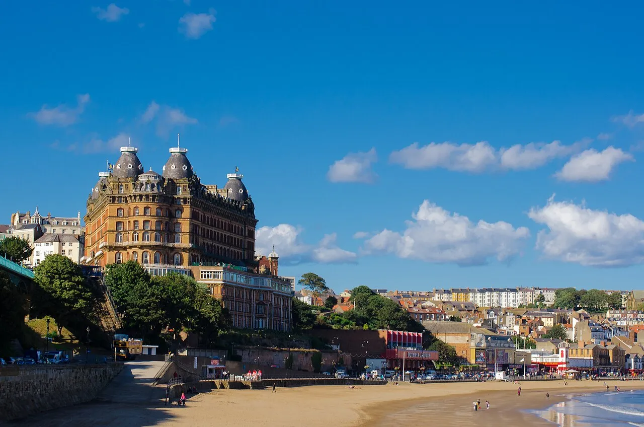
Scarborough () is a seaside town and civil parish in the district and ceremonial county of North Yorkshire, England. With a population of 61,749, Scarborough is the largest town on the Yorkshire Coast and the fourth-largest settlement in the county. It is located on the North Sea coast and is on the Cleveland Way long distance footpath which follows the coast through the town.
Source: Wikipedia · CC BY-SA 4.0
Photos of Scarborough
-

Jo and Steve Turner · CC BY-SA 2.0 -

Bob Harvey · CC BY-SA 2.0 -

Jo and Steve Turner · CC BY-SA 2.0 -

Martin Dawes · CC BY-SA 2.0 -

Thomas Tolkien from Yorkshire, UK · CC BY 2.0


Travel notes for Scarborough
From Wikivoyage
Scarborough is a resort on the North Yorkshire coast, with a population of 61,000 in 2024. It has two broad, sandy bays divided by a headland, with confident Victorian hotels ranged above.
Understand+
A castle was established on the headland in the Norman era, and the town first grew up along the more sheltered South Bay. There was fishing and sea trade, but it wasn't much of a harbour, and Scarborough mostly owes its existence to the strange course of the River Derwent. This arises nearby, but instead of flowing to the coast it turns inland, carving a broad valley between the North York Moors and the Yorkshire Wolds. So this was a natural transport route: for traders heading to Scarborough Fair, for marauding armies including the Normans, Scots and Royalists alternating with Parliamentarians, and above all for holiday-makers. In 1626 one of the springs that bubbled out of the cliffs, staining the rocks with its mineral content, was claimed to have medicinal properties. People flocked for spa cures, from the springs and from sea-bathing. The railway arrived in 1845 and there was a spate of building grand hotels, expanding into North Bay and creating the townscape you see today. Leisure fashions have evolved but Scarborough remains a popular resort because of its ease of access from the industrial cities.
Visitor North Yorkshire is the visitor information centre within Town Hall, open Mon–Fri 9AM-4:30PM.
Get in+
By road:
All routes to Scarborough get very congested on summer weekends. The main approach is along A64, which forks off A1(M) to pass York and Malton. Expect to hit tailbacks just east of York where the dual carriageway narrows to single.
Other routes are to leave A64 at York for A166 via Stamford Bridge and Bridlington; along A170 (for light vehicles only) from Thirsk and Pickering; from eastern England either via M18 then A614 or via Humber Bridge, Hull and A165; and from the north use A19 past Middlesbrough onto A171 then along the coast through Whitby.
Tune in to This is the Coast on DAB radio for travel reports to confirm that what you are stuck in is indeed a traffic jam.
Parking in town centre is ample much of the year but fills up quickly in summer. For day trips use the Park and Rides, both south side: on A64 Seamer Road and on A165 Filey Road.
By train:
TransPennine Express trains run hourly from Manchester Victoria, via Huddersfield, Leeds, York and Malton. From London and the Midlands change at York. Reservations are needed for bicycles.
Northern Rail trains run every two hours from Hull via Beverley, Bridlington, Bempton (for Flamborough Head) and Filey.
On summer weekends these trains are packed with families heading to the seaside.
1 Scarborough station is next to the main bus stand in West Square. It has a staffed ticket office and machines, a waiting room and toilets. Lots of cafes nearby. There is step-free access to all platforms.
By bus:
From London Victoria change at Leeds for the Coastliner, 10 hours in all.
Yorkshire Coastliner 843 runs hourly from Leeds via Tadcaster, York and Malton.
East Yorkshire Bus 41 runs every 30 min from Hull via Beverley and Driffield to Bridlington. Change there for the hourly 12 / 13 via Filey to Scarborough.
East Yorkshire Bus 128 runs across the North York Moors from Helmsley via Pickering, Thornton-le-Dale, Brompton and Seamer. It runs hourly Mon–Fri, every two hours Sat, no Sunday service.
Source: Wikivoyage · CC BY-SA 4.0 · abridged
Twin towns and sister cities of Scarborough
- Caher· Ireland
Source: Wikidata. Only places with a page on this site are shown.
Climate of Scarborough
Best months for sightseeingBest months for sightseeing: June–September.
This month · November
A cold month
Day 9° · Night 4° · Rain 60 mm
- Hottest month
- July (day 20°)
- Coldest month
- January (night 1°)
- Wettest month
- December (63 mm)
- Driest month
- February (41 mm)
Bars: average monthly low and high temperature. Below: precipitation. Monthly averages for 1970–2000 at about 18 km resolution, adjusted for elevation. Highlighted months are mild and relatively dry. Source: WorldClim 2.1 (CC BY 4.0).
Show values as a table
| Month | Jan | Feb | Mar | Apr | May | Jun | Jul | Aug | Sep | Oct | Nov | Dec |
|---|---|---|---|---|---|---|---|---|---|---|---|---|
| Average high (°C) | 6° | 7° | 9° | 11° | 15° | 18° | 20° | 20° | 17° | 13° | 9° | 7° |
| Average low (°C) | 1° | 1° | 2° | 4° | 6° | 9° | 11° | 11° | 9° | 7° | 4° | 2° |
| Precipitation (mm) | 61 | 41 | 49 | 49 | 49 | 55 | 50 | 59 | 55 | 58 | 60 | 63 |
Other places to visit in this season: June July August September
How to get to Scarborough
The nearest airport is Teesside International Airport (MME), 71 km to the west as the crow flies. For international flights: Leeds Bradford Airport (LBA) (94 km). The nearest large city is York, 57 km to the southwest.
Airports
- Teesside International Airport (MME) Darlington, Durham 71 kmwest
- Humberside Airport (HUY) Grimsby, Lincolnshire 78 kmsouth
- Leeds Bradford Airport (LBA) Leeds, West Yorkshire 94 kmsouthwest
Nearby large cities
- York Population: 156.1K 57 kmsouthwest
- Hull Population: 314K 60 kmsouth
- Middlesbrough Population: 142.7K 63 kmnorthwest
- Leeds Population: 536.3K 92 kmsouthwest
- Sunderland Population: 170.1K 94 kmnorthwest
Straight-line distances; road distances are longer. Airport data: OurAirports.
Day trips from Scarborough
Within 100 km: 293 historic and cultural sites, 272 natural sites, 81 lakes, rivers and coasts.
0–25 km58 places
- Peasholm Island Island 1 kmN
- Oliver's Mount Mountain 1 kmS
- Ling Hill Mountain 24 kmNW
- Seamer Beacon Mountain 3 kmW
25–60 km226 places
- Redcar Beach Beach 58 kmNW
- Whitby Beach Beach 29 kmNW
- North Beach Beach 26 kmSE
- Fraisethorpe Beach Beach 29 kmSE
60–100 km362 places
- Seaton Carew Beach Beach 66 kmNW
- The Island Island 82 kmW
- Sunk Island Island 74 kmS
- Read's Island Island 67 kmS
Straight-line distances.
Scarborough and similar cities
Side by side with cities of similar size in the same country: population, elevation and climate.
| Measure | Scarborough | Widnes | Bury | Bangor |
|---|---|---|---|---|
| Population | 61.7K | 61.5K | 61K | 61K |
| Elevation | 48 m | 13 m | 93 m | 19 m |
| Summer day (hottest month) | 20° | 20° | 20° | 20° |
| Winter night (coldest month) | 1° | 2° | 2° | 1° |
| Annual rainfall | 649 mm | 823 mm | 1,054 mm | 850 mm |
| Best months | Jun–Sep | Jun–Aug | Jun–Aug | Jun–Aug |
| Distance | — | 184 km | 146 km | 344 km |
Climate values are 1970–2000 monthly averages; straight-line distance.
Nearby attractions & nature
Everything nearby-
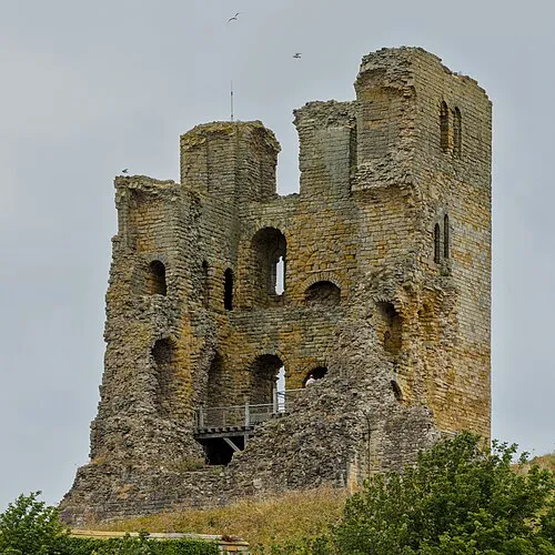 Scarborough Castle Historic site, Scarborough District1.3 km NE
-
Scarborough Castle Mountain, Scarborough District1.3 km NE
-
Oliver's Mount Mountain, Scarborough District1.4 km S
-
Prospect Mount Mountain, Scarborough District1.5 km W
-
Peasholm Island Island, Scarborough District1.4 km N
-
Scarborough Signal Station Historic site, Scarborough District1.5 km NE
-
Knox Hill Mountain, Scarborough District2.5 km S
-
South Bay Natural site, Scarborough District2.3 km SE
Sources & licences
Data last updated: · 2 independent sources