Bolsterstone Castle
Located in Stocksbridge, Sheffield Coordinates: 53°28′02″ N 1°35′32″ W
- Local time
- UTC+00:00
- Europe/London · UTC+00:00
- Elevation
- 295 m
- above sea level
- Airports
- LBA Leeds Bradford Airport45 km
- MAN Manchester Airport48 km
About Bolsterstone Castle
Bolsterstone Castle is a historic site. Location: Stocksbridge, Sheffield. The best months to visit are June–August. The nearest airport is Leeds Bradford Airport (45 km). Nearby sights include Whitwell Moor and Briery Busk.
Climate of Bolsterstone Castle
Best months for sightseeingBest months for sightseeing: June–August.
This month · November
A wet month
Day 8° · Night 3° · Rain 107 mm
- Hottest month
- July (day 19°)
- Coldest month
- February (night 0°)
- Wettest month
- December (117 mm)
- Driest month
- July (65 mm)
Bars: average monthly low and high temperature. Below: precipitation. Monthly averages for 1970–2000 at about 18 km resolution, adjusted for elevation. Highlighted months are mild and relatively dry. Source: WorldClim 2.1 (CC BY 4.0).
Show values as a table
| Month | Jan | Feb | Mar | Apr | May | Jun | Jul | Aug | Sep | Oct | Nov | Dec |
|---|---|---|---|---|---|---|---|---|---|---|---|---|
| Average high (°C) | 5° | 5° | 8° | 10° | 14° | 17° | 19° | 19° | 16° | 12° | 8° | 6° |
| Average low (°C) | 0° | 0° | 2° | 3° | 6° | 8° | 11° | 10° | 8° | 6° | 3° | 1° |
| Precipitation (mm) | 113 | 84 | 88 | 74 | 66 | 78 | 65 | 80 | 82 | 100 | 107 | 117 |
How to get to Bolsterstone Castle
The nearest airport is Leeds Bradford Airport (LBA), 45 km to the north as the crow flies. The nearest large city is Sheffield, 13 km to the southeast.
Airports
- Leeds Bradford Airport (LBA) Leeds, West Yorkshire 45 kmnorth
- Manchester Airport (MAN) Manchester, Greater Manchester 48 kmwest
- East Midlands Airport (EMA) Nottingham, Leicestershire 73 kmsouth
Nearby large cities
- Sheffield Population: 556.5K 13 kmsoutheast
- Rotherham Population: 117.6K 16 kmeast
- Huddersfield Population: 149K 24 kmnorthwest
- Wakefield Population: 109.8K 25 kmnorth
- Chesterfield Population: 113.1K 27 kmsoutheast
Straight-line distances; road distances are longer. Airport data: OurAirports.
Day trips from Bolsterstone Castle
Within 100 km: 598 historic and cultural sites, 879 natural sites, 176 lakes, rivers and coasts.
0–25 km174 places
- Don Island Island 16 kmE
- Calder Island Island 23 kmN
- Stennard Island Island 24 kmN
- Woodhead Reservoir Lake 18 kmW
25–60 km573 places
- Howden Dyke Island Island 56 kmNE
- Beal Island Island 39 kmNE
- Saint George's Island Island 45 kmW
- Heron Island Island 46 kmNE
60–100 km906 places
- Great Britain Island 65 kmNW
- Ainsdale Beach Beach 99 kmW
- The Island Island 86 kmN
- Read's Island Island 73 kmE
Straight-line distances.
Nearby attractions & nature
Everything nearby-
Whitwell Moor Mountain, Stocksbridge2.3 km W
-
Briery Busk Mountain, Stocksbridge2.6 km N
-
Little Don River River, England1.7 km E
-
Bradfield Bailey Hill Historic site, Bradfield4.2 km S
-
Bradfield Castle Hill Historic site, Bradfield4.5 km S
-
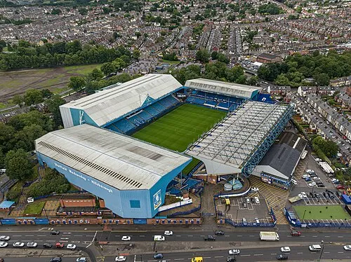 Hillsborough Stadium Landmark, Bradfield8.7 km SE
-
Edge Mount Mountain, Bradfield3.9 km S
-
Ewden Beck River, England3.4 km SE
Nearest towns and villages
-
Stocksbridge Town, Stocksbridge1.7 km N
-
Bolsterstone Village, Stocksbridge0.1 km SW
-
Ewden Village Village, Stocksbridge0.6 km S
-
Hollin Busk Neighbourhood, Stocksbridge0.8 km N
Sources & licences
Data last updated: