Holmcroft
Located in Stafford District, Staffordshire Coordinates: 52°49′21″ N 2°07′51″ W
- Elevation
- 82 m
- above sea level
- Local time
- UTC+00:00
- Europe/London · UTC+00:00
- Airports
- BHX Birmingham Airport49 km
- EMA East Midlands Airport54 km
About Holmcroft
Holmcroft is a neighbourhood. Location: Stafford District, Staffordshire. The best months to visit are June–August. The nearest airport is Birmingham Airport (49 km). Nearby sights include Stafford Castle and Castle Church Village Defences.
Photos of Holmcroft
-
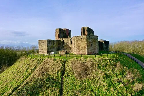
Stafford Castle Nashetty · CC0

Climate of Holmcroft
Best months for sightseeingBest months for sightseeing: June–August.
This month · November
A cold month
Day 9° · Night 4° · Rain 80 mm
- Hottest month
- July (day 20°)
- Coldest month
- February (night 1°)
- Wettest month
- November (80 mm)
- Driest month
- February (54 mm)
Bars: average monthly low and high temperature. Below: precipitation. Monthly averages for 1970–2000 at about 18 km resolution, adjusted for elevation. Highlighted months are mild and relatively dry. Source: WorldClim 2.1 (CC BY 4.0).
Show values as a table
| Month | Jan | Feb | Mar | Apr | May | Jun | Jul | Aug | Sep | Oct | Nov | Dec |
|---|---|---|---|---|---|---|---|---|---|---|---|---|
| Average high (°C) | 7° | 7° | 9° | 11° | 15° | 18° | 20° | 20° | 17° | 13° | 9° | 7° |
| Average low (°C) | 1° | 1° | 2° | 4° | 6° | 9° | 11° | 11° | 9° | 7° | 4° | 2° |
| Precipitation (mm) | 76 | 54 | 63 | 55 | 58 | 69 | 56 | 74 | 68 | 74 | 80 | 79 |
How to get to Holmcroft
The nearest airport is Birmingham Airport (BHX), 49 km to the southeast as the crow flies. The nearest large city is Stoke-on-Trent, 21 km to the north.
Airports
- Birmingham Airport (BHX) Birmingham, West Midlands 49 kmsoutheast
- East Midlands Airport (EMA) Nottingham, Leicestershire 54 kmeast
- Manchester Airport (MAN) Manchester, Greater Manchester 59 kmnorth
Nearby large cities
- Stoke-on-Trent Population: 258.4K 21 kmnorth
- Newcastle-under-Lyme Population: 127.7K 21 kmnorth
- Wolverhampton Population: 263.7K 26 kmsouth
- Telford Population: 155.6K 27 kmsouthwest
- Walsall Population: 172.1K 28 kmsouth
Straight-line distances; road distances are longer. Airport data: OurAirports.
Day trips from Holmcroft
Within 100 km: 860 historic and cultural sites, 1,554 natural sites, 137 lakes, rivers and coasts.
0–25 km89 places
- Chasewater Lake 21 kmSE
- Overmoor Mountain 23 kmN
- Ashley Heath Mountain 20 kmNW
- Castle Ring Mountain 18 kmSE
25–60 km611 places
- Horninglow island Island 34 kmE
- Crescent Wood Island Island 50 kmSE
- Brown's Island Island 29 kmSE
- Holme Nook Island 47 kmE
60–100 km1,851 places
- Thurstaston Beach Beach 89 kmNW
- Hilbre Island Island 97 kmNW
- Newark Island Island 92 kmE
- Saint George's Island Island 73 kmN
Straight-line distances.
Nearby attractions & nature
Everything nearby-
Stafford Castle Historic site, Stafford District3 km S
-
Castle Church Village Defences Historic site, Stafford District2.9 km S
-
Stafford Castle Mountain, Stafford District2.9 km S
-
Hopton Heath Mountain, Salt and Enson4.5 km NE
-
River Penk River, England4.1 km SE
-
Peasley Bank Mountain, Whitgreave5.1 km N
Sources & licences
Data last updated: