- Elevation
- 42 m
- above sea level
- Local time
- UTC+00:00
- Europe/London · UTC+00:00
- Airports
- NCL Newcastle International Airport22 km
- MME Teesside International Airport44 km
About South Hylton
South Hylton is a village. Location: Sunderland, England. Elevation: 42 m.
South Hylton () is a suburb of Sunderland, Tyne and Wear, England. Lying west of Sunderland city centre on the south bank of the River Wear, South Hylton has a population of 10,317 (2001 Census). Once a small industrial village, South Hylton (with only one access road) is now a dormitory village and is a single track terminus for the Tyne and Wear Metro. South Hylton was originally known as Hylton Ferry or Low Ford, its current name not coming into regular use until the late 18th to early 19th century.
Source: Wikipedia · CC BY-SA 4.0
Photos of South Hylton
-
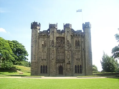
Hylton Castle Craigy · CC BY-SA 3.0

Climate of South Hylton
Best months for sightseeingBest months for sightseeing: June–September.
This month · November
A cold month
Day 10° · Night 4° · Rain 65 mm
- Hottest month
- July (day 20°)
- Coldest month
- January (night 2°)
- Wettest month
- August (65 mm)
- Driest month
- February (42 mm)
Bars: average monthly low and high temperature. Below: precipitation. Monthly averages for 1970–2000 at about 18 km resolution, adjusted for elevation. Highlighted months are mild and relatively dry. Source: WorldClim 2.1 (CC BY 4.0).
Show values as a table
| Month | Jan | Feb | Mar | Apr | May | Jun | Jul | Aug | Sep | Oct | Nov | Dec |
|---|---|---|---|---|---|---|---|---|---|---|---|---|
| Average high (°C) | 7° | 8° | 9° | 11° | 14° | 17° | 20° | 20° | 17° | 14° | 10° | 8° |
| Average low (°C) | 2° | 2° | 3° | 3° | 5° | 8° | 10° | 11° | 9° | 7° | 4° | 3° |
| Precipitation (mm) | 61 | 42 | 55 | 46 | 49 | 52 | 52 | 65 | 62 | 61 | 65 | 63 |
Other places to visit in this season: June July August September
How to get to South Hylton
The nearest airport is Newcastle International Airport (NCL), 22 km to the northwest as the crow flies. The nearest large city is Sunderland, 5 km to the east.
Airports
- Newcastle International Airport (NCL) Newcastle upon Tyne, Tyne and Wear 22 kmnorthwest
- Teesside International Airport (MME) Darlington, Durham 44 kmsouth
- Leeds Bradford Airport (LBA) Leeds, West Yorkshire 116 kmsouth
Nearby large cities
- Sunderland Population: 170.1K 5 kmeast
- Newcastle upon Tyne Population: 300.1K 13 kmnorthwest
- Middlesbrough Population: 142.7K 39 kmsouth
- York Population: 156.1K 108 kmsouth
- Leeds Population: 536.3K 123 kmsouth
Straight-line distances; road distances are longer. Airport data: OurAirports.
Day trips from South Hylton
Within 100 km: 673 historic and cultural sites, 960 natural sites, 209 lakes, rivers and coasts.
0–25 km126 places
- Saint Mary’s Island Island 19 kmN
- Match Island Island 7 kmW
- Rocky Island Island 21 kmN
- Ryton Island Island 22 kmNW
25–60 km409 places
- Longhoughton Beach Beach 60 kmN
- Seaton Carew Beach Beach 32 kmSE
- Redcar Beach Beach 39 kmSE
- Coquet Island Island 49 kmN
60–100 km1,307 places
- Cocklawburn Beach Beach 98 kmN
- Cheswick Sands Beach 96 kmN
- Whitby Beach Beach 69 kmSE
- The Island Island 75 kmS
Straight-line distances.
Nearby attractions & nature
Everything nearby-
Hylton Castle Historic site, Sunderland2.5 km N
-
WWT Washington Natural site, Sunderland2.1 km W
-
Penshaw Hill Mountain, Sunderland2.8 km SW
-
Tunstall Hills Mountain, Sunderland4.4 km SE
-
Boldon Hills Mountain, South Tyneside3.8 km N
-
Stadium Of Light Landmark, Burdon4.4 km E
Sources & licences
Data last updated: · 2 independent sources