- Elevation
- 32 m
- above sea level
- Local time
- UTC+00:00
- Europe/London · UTC+00:00
- Airports
- LGW London Gatwick Airport28 km
- LHR London Heathrow Airport30 km
About Broadford
Broadford is a village. Location: Shalford, Guildford District. Elevation: 32 m. The best months to visit are June–August. The nearest airport is London Gatwick Airport (28 km). Nearby sights include Peasmarsh Mediumwave Transmitter and Shalford Mill.
Photos of Broadford
-
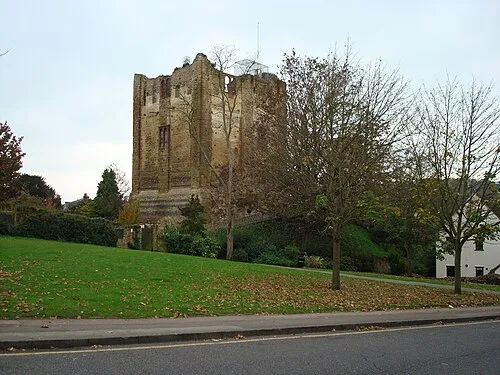
Guildford Castle SuzanneKn at English Wikipedia · Public domain

Climate of Broadford
Best months for sightseeingBest months for sightseeing: June–August.
This month · November
A cold month
Day 11° · Night 4° · Rain 71 mm
- Hottest month
- July (day 23°)
- Coldest month
- February (night 2°)
- Wettest month
- December (74 mm)
- Driest month
- July (43 mm)
Bars: average monthly low and high temperature. Below: precipitation. Monthly averages for 1970–2000 at about 18 km resolution, adjusted for elevation. Highlighted months are mild and relatively dry. Source: WorldClim 2.1 (CC BY 4.0).
Show values as a table
| Month | Jan | Feb | Mar | Apr | May | Jun | Jul | Aug | Sep | Oct | Nov | Dec |
|---|---|---|---|---|---|---|---|---|---|---|---|---|
| Average high (°C) | 8° | 8° | 11° | 13° | 17° | 20° | 23° | 22° | 19° | 15° | 11° | 8° |
| Average low (°C) | 2° | 2° | 3° | 4° | 7° | 10° | 12° | 12° | 10° | 7° | 4° | 3° |
| Precipitation (mm) | 73 | 48 | 56 | 49 | 51 | 54 | 43 | 54 | 65 | 73 | 71 | 74 |
How to get to Broadford
The nearest airport is London Gatwick Airport (LGW), 28 km to the east as the crow flies. The nearest large city is Woking, 12 km to the north.
Airports
- London Gatwick Airport (LGW) London 28 kmeast
- London Heathrow Airport (LHR) London 30 kmnorth
- London City Airport (LCY) London 55 kmnortheast
Nearby large cities
- Woking Population: 103.9K 12 kmnorth
- Crawley Population: 124K 30 kmeast
- Sutton Population: 187.6K 30 kmnortheast
- Slough Population: 164.8K 33 kmnorth
- Basingstoke Population: 107.6K 36 kmwest
Straight-line distances; road distances are longer. Airport data: OurAirports.
Day trips from Broadford
Within 100 km: 773 historic and cultural sites, 691 natural sites, 296 lakes, rivers and coasts.
0–25 km153 places
- Hamhaugh Island Island 20 kmNE
- Trinity Island Island 18 kmNE
- Bull Dog Island Island 20 kmNE
- Wheatley's Eyot Island 24 kmNE
25–60 km828 places
- Portsea Island Natural site 57 kmSW
- White Hart Lane Landmark 56 kmNE
- St Nicholas Church Shoreham Attraction 46 kmSE
- The Marlipins Museum Museum 47 kmSE
60–100 km779 places
- Isle of Wight Island 78 kmSW
- Spotlites @ Kings Theatre Attraction 79 kmE
- Avon Beach Beach 98 kmSW
- Calshot Beach Beach 68 kmSW
Straight-line distances.
Nearby attractions & nature
Everything nearby-
Peasmarsh Mediumwave Transmitter Landmark, Artington1.5 km SW
-
Shalford Mill Natural site, Guildford District1.1 km NE
-
Shalford Park Natural site, Guildford District1.5 km N
-
Guildford Castle Historic site, Guildford District2.4 km N
-
Chinthurst Hill Mountain, Wonersh1.9 km SE
-
Stoke Park Natural site, Surrey3.8 km N
Sources & licences
Data last updated: