Nuneaton
Located in Nuneaton and Bedworth District, Warwickshire Coordinates: 52°31′24″ N 1°27′55″ W
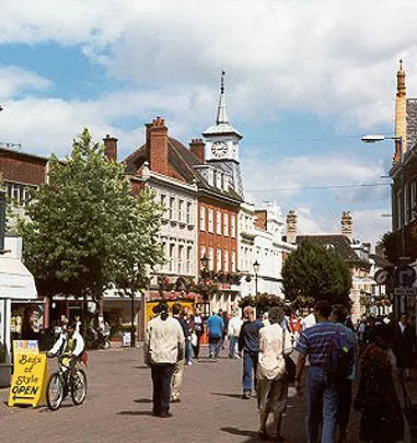
- Population
- 88,813
- 88.8K
- Elevation
- 85 m
- above sea level
- Local time
- UTC+00:00
- Europe/London · UTC+00:00
- Airports
- BHX Birmingham Airport21 km
- EMA East Midlands Airport35 km
About Nuneaton
Nuneaton is a town. Location: Nuneaton and Bedworth District, Warwickshire. Population: 88,813. Elevation: 85 m.
Nuneaton ( nə-NEE-tən) is a market town in the Nuneaton and Bedworth district, in northern Warwickshire, England, close to the county border with Leicestershire to the north-east. Nuneaton's population at the 2021 census was 88,813, making it the largest town in Warwickshire. Nuneaton's urban area, which also includes the large villages of Bulkington and Hartshill, had a population of 99,372 at the 2021 census.
Source: Wikipedia · CC BY-SA 4.0
Photos of Nuneaton
-

Bob Harvey · CC BY-SA 2.0 -

Bill Boaden · CC BY-SA 2.0 -

G-13114 · CC BY-SA 4.0 -

Rubbish computer · CC BY-SA 4.0 -

Rubbish computer · CC BY-SA 4.0


Travel notes for Nuneaton
From Wikivoyage
Nuneaton is the largest town in Warwickshire, with a population in 2021 of 89,000. It was heavily bombed in the Second World War and rebuilt in typically unsympathetic post-war style. Its best-known landmark is Mount Judd (aka the "Nuneaton Nipple"), a 518-foot spoil heap.
Understand+
"Eaton" means a settlement next to water, and the "nun" was added when a Benedictine nunnery was founded in the 12th century. In the 17th century, Nuneaton manufactured silk ribbons, and in the 19th century, it became a coal-mining town. That era was captured by George Eliot (penname of Mary Ann Evans, 1819 – 1880); born locally, her novels depict rural provincial life as it becomes challenged by the march of industry, and they refer to the town as "Milby".
Get in+
Nuneaton is 20 mi (32 km) east of Birmingham.
By car:
The town is close to the M6, M1 and M42 motorways, so is easy to reach by road from anywhere in England.
By train:
1 Nuneaton station. On an important railway junction and is served by trains on the West Coast Main Line, the Birmingham-Leicester-Peterborough Line and the Nuneaton to Coventry branch line. Direct trains from London St. Pancras International and London Euston. (updated Jul 2023)
Source: Wikivoyage · CC BY-SA 4.0 · abridged
Twin towns and sister cities of Nuneaton
- Cottbus· Germany
Source: Wikidata. Only places with a page on this site are shown.
Climate of Nuneaton
Best months for sightseeingBest months for sightseeing: June–August.
This month · November
A cold month
Day 10° · Night 3° · Rain 62 mm
- Hottest month
- July (day 21°)
- Coldest month
- February (night 1°)
- Wettest month
- December (64 mm)
- Driest month
- February (45 mm)
Bars: average monthly low and high temperature. Below: precipitation. Monthly averages for 1970–2000 at about 18 km resolution, adjusted for elevation. Highlighted months are mild and relatively dry. Source: WorldClim 2.1 (CC BY 4.0).
Show values as a table
| Month | Jan | Feb | Mar | Apr | May | Jun | Jul | Aug | Sep | Oct | Nov | Dec |
|---|---|---|---|---|---|---|---|---|---|---|---|---|
| Average high (°C) | 7° | 7° | 10° | 12° | 16° | 19° | 21° | 21° | 18° | 14° | 10° | 8° |
| Average low (°C) | 1° | 1° | 2° | 3° | 6° | 9° | 11° | 11° | 9° | 6° | 3° | 2° |
| Precipitation (mm) | 60 | 45 | 50 | 47 | 50 | 56 | 49 | 61 | 59 | 59 | 62 | 64 |
How to get to Nuneaton
The nearest airport is Birmingham Airport (BHX), 21 km to the west as the crow flies. The nearest large city is Coventry, 13 km to the south.
Airports
- Birmingham Airport (BHX) Birmingham, West Midlands 21 kmwest
- East Midlands Airport (EMA) Nottingham, Leicestershire 35 kmnorth
- London Luton Airport (LTN) Luton, Luton 104 kmsoutheast
Nearby large cities
- Coventry Population: 345.3K 13 kmsouth
- Sutton Coldfield Population: 109.9K 24 kmwest
- Solihull Population: 126.6K 25 kmsouthwest
- Leicester Population: 368.6K 26 kmnortheast
- Birmingham Population: 1.2M 30 kmwest
Straight-line distances; road distances are longer. Airport data: OurAirports.
Day trips from Nuneaton
Within 100 km: 720 historic and cultural sites, 846 natural sites, 126 lakes, rivers and coasts.
0–25 km88 places
- Crescent Wood Island Island 19 kmSW
- Lake Lake 21 kmSW
- Bardon Hill Mountain 23 kmNE
- Oldbury Hill Mountain 6 kmNW
25–60 km406 places
- Horninglow island Island 33 kmN
- Glover's Island Island 58 kmSW
- Barton Island Island 45 kmN
- The Islands Island 28 kmE
60–100 km1,198 places
- Alney Island Island 91 kmSW
- Andersey Island Island 96 kmS
- Newark Island Island 75 kmNE
- Rose Isle Island 91 kmS
Straight-line distances.
Nuneaton and similar cities
Side by side with cities of similar size in the same country: population, elevation and climate.
| Measure | Nuneaton | Hartlepool | Grays | Chester |
|---|---|---|---|---|
| Population | 88.8K | 88.9K | 89.8K | 90.5K |
| Elevation | 85 m | 11 m | 13 m | 34 m |
| Summer day (hottest month) | 21° | 20° | 22° | 20° |
| Winter night (coldest month) | 1° | 2° | 2° | 1° |
| Annual rainfall | 662 mm | 751 mm | 645 mm | 695 mm |
| Best months | Jun–Aug | Jun–Sep | Jun–Aug | Jun–Aug |
| Distance | — | 241 km | 169 km | 121 km |
Climate values are 1970–2000 monthly averages; straight-line distance.
Nearby attractions & nature
Everything nearby-
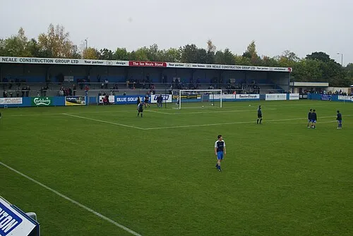 Liberty Way Landmark, Nuneaton and Bedworth District1.6 km E
-
Mount Jud Mountain, Nuneaton and Bedworth District1.8 km NW
-
Sutton Park Natural site, Nuneaton and Bedworth District3.7 km NW
-
Hartshill Pyramid Mountain, Hartshill4.2 km NW
-
Hartshill Castle Historic site, Hartshill4.6 km NW
-
Hinckley Castle Hill Historic site, Hinckley and Bosworth District6.7 km E
-
Astley Castle Historic site, Astley5.8 km SW
-
Oldbury Camp Historic site, Hartshill5.8 km NW
Sources & licences
Data last updated: · 2 independent sources