- Elevation
- 58 m
- above sea level
- Local time
- UTC+00:00
- Europe/London · UTC+00:00
- Airports
- LGW London Gatwick Airport3 km
- LHR London Heathrow Airport41 km
About Fernhill
Fernhill is a village. Location: Crawley District, West Sussex. Elevation: 58 m.
Fernhill is a hamlet close to Gatwick Airport in West Sussex, England. Its fields and farmhouses formerly straddled the county boundary between Surrey and West Sussex, but since 1990 (when there were about 60 households) the whole area has been part of the county of West Sussex and the borough of Crawley. Fernhill is bounded on three sides by motorways and the airport. A fatal aeroplane crash occurred here in 1969.
Source: Wikipedia · CC BY-SA 4.0
Photos of Fernhill
-
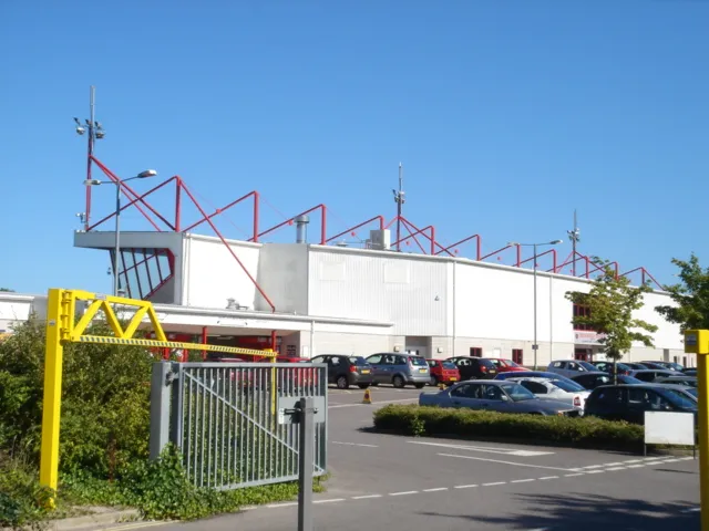
Broadfield Stadium Hassocks5489 at English Wikipedia · Public domain

Climate of Fernhill
Best months for sightseeingBest months for sightseeing: June–August.
This month · November
A cold month
Day 11° · Night 4° · Rain 85 mm
- Hottest month
- July (day 21°)
- Coldest month
- February (night 1°)
- Wettest month
- January (88 mm)
- Driest month
- July (43 mm)
Bars: average monthly low and high temperature. Below: precipitation. Monthly averages for 1970–2000 at about 18 km resolution, adjusted for elevation. Highlighted months are mild and relatively dry. Source: WorldClim 2.1 (CC BY 4.0).
Show values as a table
| Month | Jan | Feb | Mar | Apr | May | Jun | Jul | Aug | Sep | Oct | Nov | Dec |
|---|---|---|---|---|---|---|---|---|---|---|---|---|
| Average high (°C) | 7° | 8° | 10° | 12° | 16° | 19° | 21° | 21° | 18° | 15° | 11° | 8° |
| Average low (°C) | 2° | 1° | 3° | 4° | 7° | 10° | 12° | 12° | 10° | 7° | 4° | 3° |
| Precipitation (mm) | 88 | 56 | 61 | 52 | 50 | 58 | 43 | 54 | 67 | 81 | 85 | 87 |
How to get to Fernhill
The nearest airport is London Gatwick Airport (LGW), 3 km to the west as the crow flies. The nearest large city is Crawley, 5 km to the southwest.
Airports
- London Gatwick Airport (LGW) London 3 kmwest
- London Heathrow Airport (LHR) London 41 kmnorthwest
- London City Airport (LCY) London 41 kmnorth
Nearby large cities
- Crawley Population: 124K 5 kmsouthwest
- Sutton Population: 187.6K 22 kmnorth
- Croydon Population: 173.3K 26 kmnorth
- Woking Population: 103.9K 34 kmnorthwest
- Brighton Population: 283.9K 36 kmsouth
Straight-line distances; road distances are longer. Airport data: OurAirports.
Day trips from Fernhill
Within 100 km: 734 historic and cultural sites, 597 natural sites, 295 lakes, rivers and coasts.
0–25 km104 places
- Hawk Island Island 22 kmSE
- Sixteen Acre Island Island 19 kmE
- Two Bridges Island Island 19 kmE
- Ardingly Reservoir Lake 12 kmS
25–60 km858 places
- White Hart Lane Landmark 50 kmN
- Spotlites @ Kings Theatre Attraction 54 kmNE
- St Nicholas Church Shoreham Attraction 36 kmS
- The Marlipins Museum Museum 37 kmS
60–100 km664 places
- Portsea Island Natural site 76 kmSW
- Isle of Wight Island 96 kmSW
- Isle of Sheppey Island 74 kmE
- Camber Sands Beach 70 kmE
Straight-line distances.
Nearby attractions & nature
Everything nearby-
Thunderfield Castle Historic site, Horley1.4 km N
-
Broadfield Stadium Landmark, Crawley District7 km SW
-
Gay House Hill Mountain, Outwood5.7 km NE
-
Duxhurst Mediumwave Transmitter Landmark, Salfords and Sidlow5.6 km NW
-
Hedgecourt Lake Lake, Felbridge6 km E
-
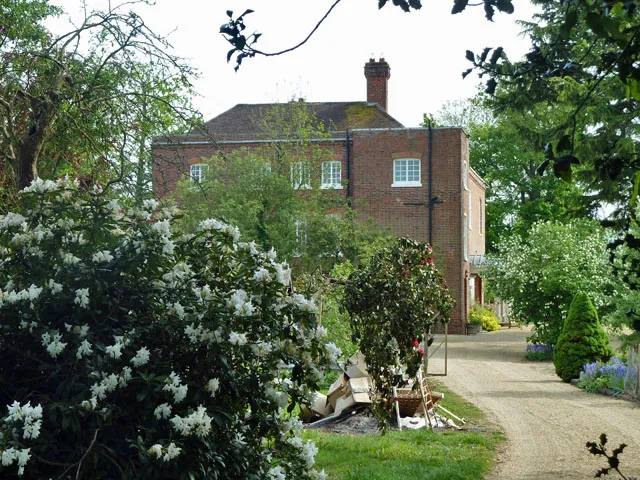 Starborough Castle Historic site, Dormansland13 km E
Other cities and towns in Crawley District
-
Shipley Bridge Village, Crawley District1 km SE
-
Forge Wood Neighbourhood, Crawley District1.8 km S
-
 Tilgate Village, Crawley District6.3 km S
-
Lowfield Heath Village, Crawley District3.1 km SW
-
County Oak Neighbourhood, Crawley District3.4 km SW
-
Burleys Wood Neighbourhood, Crawley District3.9 km S
Sources & licences
Data last updated: · 2 independent sources