- Population
- 1,060
- 1.1K
- Elevation
- 76 m
- above sea level
- Local time
- UTC+00:00
- Europe/London · UTC+00:00
- Airports
- ABZ Aberdeen International Airport49 km
- DND Dundee Airport52 km
About Saint Cyrus
Saint Cyrus is a village. Location: Aberdeenshire, Scotland. Population: 1,060. Elevation: 76 m. The best months to visit are June–August. The nearest airport is Aberdeen International Airport (49 km). Nearby sights include Woodstone Hill and Hill of Morphie.
Photos of Saint Cyrus
-
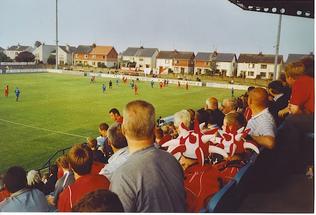
Links Park Colin Smith · CC BY-SA 2.0

Climate of Saint Cyrus
Best months for sightseeingBest months for sightseeing: June–August.
This month · November
A cold month
Day 7° · Night 1° · Rain 71 mm
- Hottest month
- July (day 19°)
- Coldest month
- January (night -2°)
- Wettest month
- January (79 mm)
- Driest month
- April (44 mm)
Bars: average monthly low and high temperature. Below: precipitation. Monthly averages for 1970–2000 at about 18 km resolution, adjusted for elevation. Highlighted months are mild and relatively dry. Source: WorldClim 2.1 (CC BY 4.0).
Show values as a table
| Month | Jan | Feb | Mar | Apr | May | Jun | Jul | Aug | Sep | Oct | Nov | Dec |
|---|---|---|---|---|---|---|---|---|---|---|---|---|
| Average high (°C) | 4° | 6° | 9° | 12° | 15° | 18° | 19° | 19° | 16° | 12° | 7° | 5° |
| Average low (°C) | -2° | -2° | 0° | 2° | 5° | 8° | 10° | 9° | 7° | 4° | 1° | -2° |
| Precipitation (mm) | 79 | 53 | 57 | 44 | 56 | 52 | 58 | 69 | 69 | 78 | 71 | 67 |
How to get to Saint Cyrus
The nearest airport is Aberdeen International Airport (ABZ), 49 km to the north as the crow flies. The nearest large city is Aberdeen, 45 km to the northeast.
Airports
- Aberdeen International Airport (ABZ) Aberdeen 49 kmnorth
- Dundee Airport (DND) Dundee 52 kmsouthwest
- Edinburgh Airport (EDI) Ingliston, Edinburgh 109 kmsouthwest
Nearby large cities
- Aberdeen Population: 198.6K 45 kmnortheast
- Dundee Population: 148.2K 48 kmsouthwest
- Edinburgh Population: 515K 104 kmsouthwest
- Glasgow Population: 626.4K 152 kmsouthwest
- Newcastle upon Tyne Population: 300.1K 207 kmsouth
Straight-line distances; road distances are longer. Airport data: OurAirports.
Day trips from Saint Cyrus
Within 100 km: 92 historic and cultural sites, 1,911 natural sites, 347 lakes, rivers and coasts.
0–25 km122 places
- Montrose Basin Lake 8 kmSW
- Duns Dish Lake 10 kmSW
- Hill of Wirren Mountain 24 kmW
- White Caterthun Mountain 20 kmW
25–60 km702 places
- Balbithan Island Island 52 kmN
- Aberdeen Beach Beach 47 kmNE
- Stanners Island Island 48 kmW
- Loch Wharral Lake 40 kmW
60–100 km1,526 places
- Newburgh Seals Beach Beach 65 kmNE
- Burntisland Beach Beach 94 kmSW
- Gullane Beach Beach 86 kmS
- Seacliff Beach Beach 82 kmS
Straight-line distances.
Nearby attractions & nature
Everything nearby-
Woodstone Hill Mountain, Aberdeenshire1.9 km N
-
Hill of Morphie Mountain, Aberdeenshire2.1 km W
-
Montrose Bay Natural site, Aberdeenshire2.5 km S
-
Links Park Landmark, Angus7.3 km S
-
Cloch Hill Mountain, Aberdeenshire4.6 km NE
-
Hill of Garvock Mountain, Aberdeenshire4.7 km NW
Other cities and towns in Aberdeenshire
-
 Laurencekirk Village, Aberdeenshire7.2 km NW
-
 Inverbervie Village, Aberdeenshire11 km NE
-
Gourdon Village, Aberdeenshire10 km NE
-
 Benholm Village, Aberdeenshire7.3 km NE
-
Garvock Village, Aberdeenshire4.6 km N
-
Auchenblae Village, Aberdeenshire14 km N
Sources & licences
Data last updated: