Portnaughan Bay
Located in Dumfries and Galloway, Scotland Coordinates: 54°58′55″ N 5°10′56″ W
- Elevation
- 13 m
- above sea level
- Local time
- UTC+00:00
- Europe/London · UTC+00:00
- Airports
- CAL Campbeltown Airport60 km
- BHD George Best Belfast City Airport60 km
About Portnaughan Bay
Portnaughan Bay is a natural site. Location: Dumfries and Galloway, Scotland. The best months to visit are June–August. The nearest airport is Campbeltown Airport (60 km). Nearby sights include Portlong Bay and Dounam Bay.
Photos of Portnaughan Bay
-
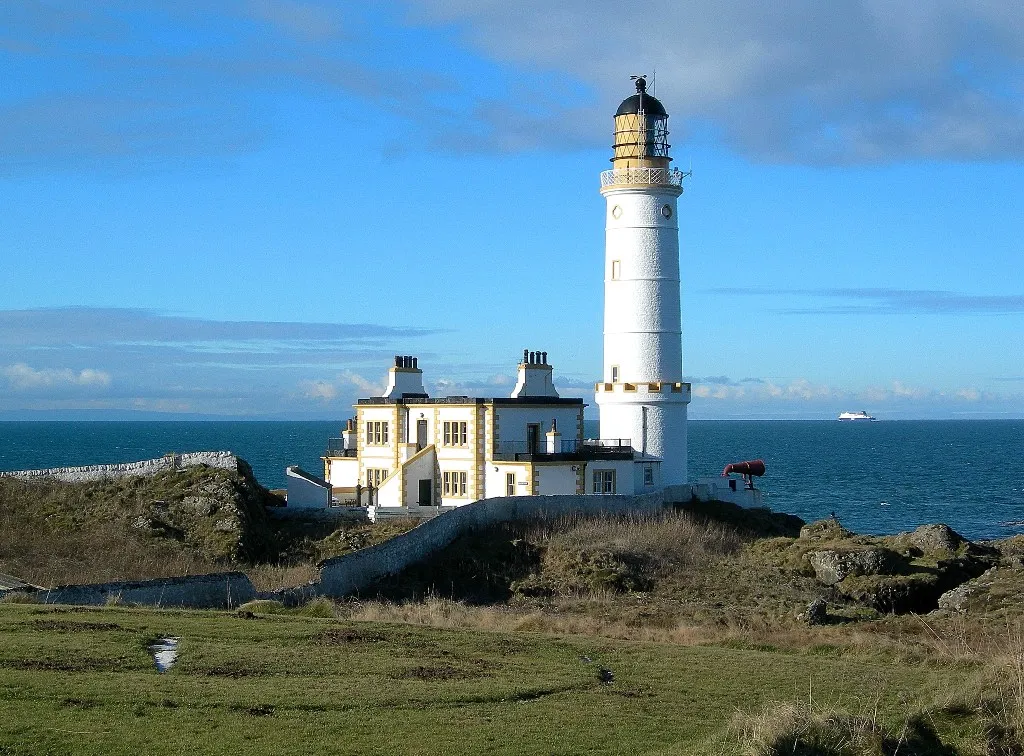
Corsewall Lighthouse Mary and Angus Hogg · CC BY-SA 2.0

Climate of Portnaughan Bay
Best months for sightseeingBest months for sightseeing: June–August.
This month · November
A wet month
Day 10° · Night 4° · Rain 111 mm
- Hottest month
- July (day 18°)
- Coldest month
- February (night 1°)
- Wettest month
- October (114 mm)
- Driest month
- May (53 mm)
Bars: average monthly low and high temperature. Below: precipitation. Monthly averages for 1970–2000 at about 18 km resolution, adjusted for elevation. Highlighted months are mild and relatively dry. Source: WorldClim 2.1 (CC BY 4.0).
Show values as a table
| Month | Jan | Feb | Mar | Apr | May | Jun | Jul | Aug | Sep | Oct | Nov | Dec |
|---|---|---|---|---|---|---|---|---|---|---|---|---|
| Average high (°C) | 7° | 7° | 9° | 11° | 14° | 17° | 18° | 18° | 16° | 13° | 10° | 8° |
| Average low (°C) | 2° | 1° | 3° | 4° | 6° | 9° | 11° | 11° | 9° | 7° | 4° | 3° |
| Precipitation (mm) | 111 | 78 | 83 | 60 | 53 | 65 | 71 | 89 | 93 | 114 | 111 | 109 |
How to get to Portnaughan Bay
The nearest airport is Campbeltown Airport (CAL), 60 km to the northwest as the crow flies. For international flights: Glasgow Prestwick Airport (PIK) (69 km). The nearest large city is Belfast, 64 km to the southwest.
Airports
- Campbeltown Airport (CAL) Campbeltown 60 kmnorthwest
- George Best Belfast City Airport (BHD) Belfast 60 kmsouthwest
- Glasgow Prestwick Airport (PIK) Prestwick, South Ayrshire 69 kmnortheast
Nearby large cities
- Belfast Population: 348K 64 kmsouthwest
- Glasgow Population: 626.4K 114 kmnortheast
- Edinburgh Population: 515K 166 kmnortheast
- Blackpool Population: 145K 190 kmsoutheast
- Dublin Population: 1M 196 kmsouth
Straight-line distances; road distances are longer. Airport data: OurAirports.
Day trips from Portnaughan Bay
Within 100 km: 80 historic and cultural sites, 1,355 natural sites, 492 lakes, rivers and coasts.
0–25 km104 places
- Isle of Lochnaw Island 7 kmSE
- Heron Isle Island 17 kmSE
- Well Island Island 8 kmSE
- Duck Island Island 7 kmSE
25–60 km559 places
- West Maiden Island 36 kmW
- Sheep Island Island 43 kmNW
- Sanda Island Island 42 kmNW
- Pladda Island 50 kmN
60–100 km1,264 places
- Isle of Arran Island 69 kmN
- Great Cumbrae Island Island 89 kmN
- Ayr Beach Beach 63 kmNE
- Troon Beach Beach 70 kmNE
Straight-line distances.
Nearest towns and villages
Nearby attractions & nature
Everything nearby-
Portlong Bay Natural site, Dumfries and Galloway0.7 km SW
-
Dounam Bay Natural site, Dumfries and Galloway1.1 km S
-
Salt Pan Bay Natural site, Scotland1.7 km S
-
Cairnbowie Hill Mountain, Dumfries and Galloway2.4 km E
-
Bine Hill Mountain, Dumfries and Galloway2.6 km E
-
Corsewall Lighthouse Landmark, Dumfries and Galloway3.1 km NE
-
Blair More Hill Mountain, Dumfries and Galloway4.1 km E
-
Strool Bay Natural site, Dumfries and Galloway4.4 km S
Sources & licences
Data last updated: