- Elevation
- 472 m
- above sea level
- Local time
- UTC+00:00
- Europe/London · UTC+00:00
- Airports
- DND Dundee Airport63 km
- INV Inverness Airport82 km
About Druim a' Chait
Druim a' Chait is a mountain. Location: Perth and Kinross, Scotland. Elevation: 472 m. The best months to visit are July–August. The nearest airport is Dundee Airport (63 km). Nearby sights include Meall Duibhinidh and Meall Dail Min.
Photos of Druim a' Chait
-
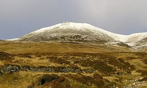
Carn a' Chlamain Grinner · CC BY-SA 3.0

Climate of Druim a' Chait
Best months for sightseeingBest months for sightseeing: July–August.
This month · November
A wet month
Day 6° · Night 0° · Rain 128 mm
- Hottest month
- July (day 17°)
- Coldest month
- January (night -2°)
- Wettest month
- January (161 mm)
- Driest month
- April (66 mm)
Bars: average monthly low and high temperature. Below: precipitation. Monthly averages for 1970–2000 at about 18 km resolution, adjusted for elevation. Highlighted months are mild and relatively dry. Source: WorldClim 2.1 (CC BY 4.0).
Show values as a table
| Month | Jan | Feb | Mar | Apr | May | Jun | Jul | Aug | Sep | Oct | Nov | Dec |
|---|---|---|---|---|---|---|---|---|---|---|---|---|
| Average high (°C) | 4° | 4° | 6° | 9° | 12° | 15° | 17° | 16° | 13° | 10° | 6° | 4° |
| Average low (°C) | -2° | -2° | -1° | 1° | 3° | 6° | 8° | 8° | 6° | 3° | 0° | -1° |
| Precipitation (mm) | 161 | 101 | 114 | 66 | 77 | 72 | 75 | 84 | 110 | 135 | 128 | 132 |
How to get to Druim a' Chait
The nearest airport is Dundee Airport (DND), 63 km to the southeast as the crow flies. For international flights: Edinburgh Airport (EDI) (100 km). The nearest large city is Dundee, 64 km to the southeast.
Airports
- Dundee Airport (DND) Dundee 63 kmsoutheast
- Inverness Airport (INV) Inverness, Highland 82 kmnorth
- Edinburgh Airport (EDI) Ingliston, Edinburgh 100 kmsouth
Nearby large cities
- Dundee Population: 148.2K 64 kmsoutheast
- Edinburgh Population: 515K 104 kmsouth
- Glasgow Population: 626.4K 110 kmsouth
- Aberdeen Population: 198.6K 110 kmeast
- Newcastle upon Tyne Population: 300.1K 247 kmsoutheast
Straight-line distances; road distances are longer. Airport data: OurAirports.
Day trips from Druim a' Chait
Within 100 km: 117 historic and cultural sites, 4,069 natural sites, 798 lakes, rivers and coasts.
0–25 km421 places
- Lamb Island Island 23 kmSE
- West Mains Island Island 18 kmS
- Pitnacree Island Island 18 kmS
- Eilean Eas Chliabhan Island 20 kmSW
25–60 km1,714 places
- Moncreiffe Island Island 54 kmSE
- Eilean an Tuilaich Island 57 kmW
- Eilean an Righ Island 43 kmW
- Isle of Spar Island 29 kmSW
60–100 km2,849 places
- Findlays Seat Mountain 91 kmNE
- Burntisland Beach Beach 92 kmSE
- Cramond beach Beach 98 kmS
- Moy Island Island 93 kmNW
Straight-line distances.
Nearest towns and villages
-
Fenderbridge Neighbourhood, Perth and Kinross4.6 km S
-
Middlebridge Neighbourhood, Perth and Kinross4.8 km S
-
 Bridge of Tilt Village, Perth and Kinross5.9 km S
-
 Blair Atholl Village, Perth and Kinross6.3 km SW
-
Sawmill Cottages Village, Perth and Kinross6.4 km S
-
 Pitlochry Village, Perth and Kinross13 km S
Nearby attractions & nature
Everything nearby-
Meall Duibhinidh Mountain, Perth and Kinross1.2 km E
-
Meall Dail Min Mountain, Perth and Kinross1.9 km S
-
Glen Tilt Natural site, Perth and Kinross2.5 km SW
-
Elrig Mountain, Perth and Kinross2.9 km NW
-
Carn a' Chlamain Mountain, Perth and Kinross5.1 km N
-
Meall Reamhar Mountain, Perth and Kinross3.5 km W
-
Braigh Clais Daimh Mountain, Perth and Kinross3.7 km N
-
Cnoc Monzie Mountain, Perth and Kinross3.8 km SE
Sources & licences
Data last updated: