Mosshouses Moor
Located in The Scottish Borders, Scotland Coordinates: 55°39′05″ N 2°45′09″ W
- Elevation
- 299 m
- above sea level
- Local time
- UTC+00:00
- Europe/London · UTC+00:00
- Airports
- EDI Edinburgh Airport51 km
- DND Dundee Airport91 km
About Mosshouses Moor
Mosshouses Moor is a mountain. Location: The Scottish Borders, Scotland. Elevation: 299 m. The best months to visit are June–August. The nearest airport is Edinburgh Airport (51 km). Nearby sights include Blackcock Hill and Jeaniefield Hill.
Photos of Mosshouses Moor
-
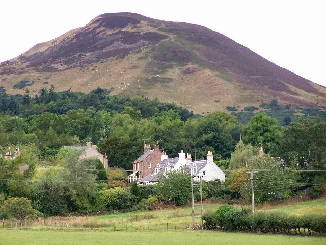
Eildon Hills Jenny Gumbrell · CC BY-SA 2.0

Climate of Mosshouses Moor
Best months for sightseeingBest months for sightseeing: June–August.
This month · November
A cold month
Day 8° · Night 1° · Rain 93 mm
- Hottest month
- July (day 18°)
- Coldest month
- January (night -1°)
- Wettest month
- October (98 mm)
- Driest month
- April (57 mm)
Bars: average monthly low and high temperature. Below: precipitation. Monthly averages for 1970–2000 at about 18 km resolution, adjusted for elevation. Highlighted months are mild and relatively dry. Source: WorldClim 2.1 (CC BY 4.0).
Show values as a table
| Month | Jan | Feb | Mar | Apr | May | Jun | Jul | Aug | Sep | Oct | Nov | Dec |
|---|---|---|---|---|---|---|---|---|---|---|---|---|
| Average high (°C) | 5° | 5° | 7° | 10° | 13° | 16° | 18° | 17° | 15° | 11° | 8° | 6° |
| Average low (°C) | -1° | -1° | 0° | 1° | 4° | 7° | 9° | 8° | 7° | 4° | 1° | 0° |
| Precipitation (mm) | 93 | 69 | 76 | 57 | 60 | 67 | 71 | 84 | 86 | 98 | 93 | 92 |
How to get to Mosshouses Moor
The nearest airport is Edinburgh Airport (EDI), 51 km to the northwest as the crow flies. The nearest large city is Edinburgh, 44 km to the northwest.
Airports
- Edinburgh Airport (EDI) Ingliston, Edinburgh 51 kmnorthwest
- Dundee Airport (DND) Dundee 91 kmnorth
- Newcastle International Airport (NCL) Newcastle upon Tyne, Tyne and Wear 96 kmsoutheast
Nearby large cities
- Edinburgh Population: 515K 44 kmnorthwest
- Dundee Population: 148.2K 92 kmnorth
- Glasgow Population: 626.4K 97 kmwest
- Newcastle upon Tyne Population: 300.1K 105 kmsoutheast
- Sunderland Population: 170.1K 120 kmsoutheast
Straight-line distances; road distances are longer. Airport data: OurAirports.
Day trips from Mosshouses Moor
Within 100 km: 565 historic and cultural sites, 2,130 natural sites, 552 lakes, rivers and coasts.
0–25 km242 places
- Wooden Anna Island 22 kmE
- Sharpitlaw Anna Island 22 kmE
- Oldmill Island Island 13 kmSE
- The Batta Island 13 kmW
25–60 km1,412 places
- Burntisland Beach Beach 54 kmNW
- Cramond beach Beach 50 kmNW
- Portobello Beach Beach 41 kmNW
- Gullane Beach Beach 44 kmN
60–100 km1,593 places
- Powillimount Beach Beach 99 kmSW
- Longhoughton Beach Beach 77 kmE
- South Wamses Island 71 kmE
- Old Law Island 61 kmE
Straight-line distances.
Nearest towns and villages


Nearby attractions & nature
Everything nearby-
Blackcock Hill Mountain, The Scottish Borders2 km NW
-
Jeaniefield Hill Mountain, The Scottish Borders2.7 km N
-
Ladhope Moor Mountain, The Scottish Borders3 km SW
-
Darling's Hill Mountain, The Scottish Borders3.3 km SW
-
Scabbet Hill Mountain, The Scottish Borders3.4 km SE
-
Buckholm Hill Mountain, The Scottish Borders4.4 km SW
-
Wester Hill Mountain, The Scottish Borders4.5 km SW
-
William Law Mountain, The Scottish Borders4.8 km W
Sources & licences
Data last updated: