Erskine Bridge
Located in West Dunbartonshire, Scotland Coordinates: 55°55′13″ N 4°27′44″ W
- Local time
- UTC+00:00
- Europe/London · UTC+00:00
- Elevation
- 2 m
- above sea level
- Airports
- GLA Glasgow Airport6 km
- PIK Glasgow Prestwick Airport47 km
About Erskine Bridge
Erskine Bridge is a landmark. Location: West Dunbartonshire, Scotland.
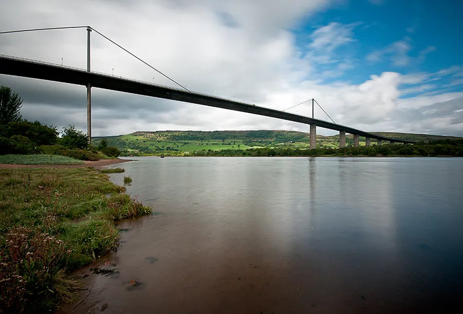
The Erskine Bridge is a multi span cable-stayed box girder bridge spanning the River Clyde in west central Scotland. The bridge connects West Dunbartonshire with Renfrewshire and can be used by all types of motor vehicles, cyclists and pedestrians. As well as crossing the Clyde, the bridge also crosses the Forth and Clyde Canal and the North Clyde railway line. A small part of Kilpatrick railway station is situated underneath the bridge at the north side. The bridge is part of the A898 road.
Source: Wikipedia · CC BY-SA 4.0
At a glance
- Opened
- 1971
- Heritage designation
- category A listed building
- Height
- 45 m
- Length
- 1.3 km
Source: Wikidata
Photos of Erskine Bridge
-

Leslie Barrie · CC BY-SA 2.0 -

marsupium photography · CC BY-SA 2.0 -

EthelRedThePetrolHead · CC BY 2.0 -

wfmillar · CC BY-SA 2.0 -

easylocum · CC BY 2.0


Climate of Erskine Bridge
Best months for sightseeingBest months for sightseeing: June–August.
This month · November
A wet month
Day 9° · Night 4° · Rain 148 mm
- Hottest month
- July (day 19°)
- Coldest month
- January (night 2°)
- Wettest month
- January (161 mm)
- Driest month
- April (69 mm)
Bars: average monthly low and high temperature. Below: precipitation. Monthly averages for 1970–2000 at about 18 km resolution, adjusted for elevation. Highlighted months are mild and relatively dry. Source: WorldClim 2.1 (CC BY 4.0).
Show values as a table
| Month | Jan | Feb | Mar | Apr | May | Jun | Jul | Aug | Sep | Oct | Nov | Dec |
|---|---|---|---|---|---|---|---|---|---|---|---|---|
| Average high (°C) | 7° | 7° | 9° | 11° | 15° | 17° | 19° | 18° | 16° | 13° | 9° | 7° |
| Average low (°C) | 2° | 2° | 3° | 4° | 6° | 9° | 11° | 11° | 9° | 7° | 4° | 2° |
| Precipitation (mm) | 161 | 111 | 121 | 69 | 73 | 70 | 80 | 96 | 129 | 152 | 148 | 147 |
How to get to Erskine Bridge
The nearest airport is Glasgow Airport (GLA), 6 km to the south as the crow flies. The nearest large city is Glasgow, 14 km to the southeast.
Airports
- Glasgow Airport (GLA) Glasgow 6 kmsouth
- Glasgow Prestwick Airport (PIK) Prestwick, South Ayrshire 47 kmsouth
- Edinburgh Airport (EDI) Ingliston, Edinburgh 68 kmeast
Nearby large cities
- Glasgow Population: 626.4K 14 kmsoutheast
- Edinburgh Population: 515K 79 kmeast
- Dundee Population: 148.2K 111 kmnortheast
- Belfast Population: 348K 174 kmsouthwest
- Aberdeen Population: 198.6K 199 kmnortheast
Straight-line distances; road distances are longer. Airport data: OurAirports.
Day trips from Erskine Bridge
Within 100 km: 170 historic and cultural sites, 3,716 natural sites, 1,185 lakes, rivers and coasts.
0–25 km271 places
- Inchlonaig Island 22 kmNW
- Inchcailloch Island 19 kmN
- Aber Isle Island 17 kmN
- Bucinch Island 21 kmNW
25–60 km1,225 places
- Great Cumbrae Island Island 33 kmSW
- Ayr Beach Beach 52 kmS
- Troon Beach Beach 44 kmS
- Hunterston Sands Beach 35 kmSW
60–100 km3,575 places
- Isle of Arran Island 61 kmSW
- Burntisland Beach Beach 79 kmE
- Cramond beach Beach 73 kmE
- Portobello Beach Beach 85 kmE
Straight-line distances.
Nearby attractions & nature
Everything nearby-
Donald's Quay Light Landmark, West Dunbartonshire0.7 km NW
-
Rashielee Light Landmark, Renfrewshire2 km SE
-
Craigend Hill Mountain, Renfrewshire1.8 km S
-
Hill of Dun Mountain, West Dunbartonshire2.4 km NW
-
Dalmuir Light Landmark, West Dunbartonshire3.4 km SE
-
The Slacks Mountain, West Dunbartonshire2.8 km N
-
Cochno Hill Mountain, West Dunbartonshire3.8 km NE
-
Creigarestie Mountain, West Dunbartonshire3.8 km N
Nearest towns and villages
-
Old Kilpatrick Village, West Dunbartonshire0.5 km NE
-
 Erskine Town, Renfrewshire2.3 km S
-
Dalmuir Town, West Dunbartonshire2.3 km SE
-
Duntocher Town, West Dunbartonshire3 km E
Sources & licences
Data last updated: · 2 independent sources