
- Population
- 4,710
- 4.7K
- Elevation
- 125 m
- above sea level
- Local time
- UTC+00:00
- Europe/London · UTC+00:00
- Airports
- EDI Edinburgh Airport9 km
- GLA Glasgow Airport61 km
About East Calder
East Calder is a village. Location: West Lothian, Scotland. Population: 4,710. Elevation: 125 m.
East Calder is a village located in West Lothian, Scotland, about one mile (1.5 kilometres) east of Mid Calder and one mile (1.5 kilometres) west of Wilkieston. It forms part of 'the Calders (together with Mid and West Calder), three small neighbouring communities situated west of Edinburgh and south of the town of Livingston.
Source: Wikipedia · CC BY-SA 4.0
Photos of East Calder
-
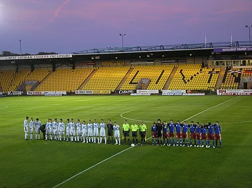
Almondvale Stadium al.im.an · Public domain

Climate of East Calder
Best months for sightseeingBest months for sightseeing: June–August.
This month · November
A cold month
Day 9° · Night 3° · Rain 83 mm
- Hottest month
- July (day 19°)
- Coldest month
- January (night 1°)
- Wettest month
- October (90 mm)
- Driest month
- April (51 mm)
Bars: average monthly low and high temperature. Below: precipitation. Monthly averages for 1970–2000 at about 18 km resolution, adjusted for elevation. Highlighted months are mild and relatively dry. Source: WorldClim 2.1 (CC BY 4.0).
Show values as a table
| Month | Jan | Feb | Mar | Apr | May | Jun | Jul | Aug | Sep | Oct | Nov | Dec |
|---|---|---|---|---|---|---|---|---|---|---|---|---|
| Average high (°C) | 6° | 6° | 8° | 11° | 14° | 17° | 19° | 18° | 16° | 12° | 9° | 7° |
| Average low (°C) | 1° | 1° | 2° | 3° | 6° | 9° | 11° | 10° | 8° | 6° | 3° | 1° |
| Precipitation (mm) | 89 | 63 | 73 | 51 | 56 | 62 | 63 | 66 | 80 | 90 | 83 | 88 |
How to get to East Calder
The nearest airport is Edinburgh Airport (EDI), 9 km to the northeast as the crow flies. The nearest large city is Edinburgh, 18 km to the east.
Airports
- Edinburgh Airport (EDI) Ingliston, Edinburgh 9 kmnortheast
- Glasgow Airport (GLA) Glasgow 61 kmwest
- Dundee Airport (DND) Dundee 68 kmnortheast
Nearby large cities
- Edinburgh Population: 515K 18 kmeast
- Glasgow Population: 626.4K 50 kmwest
- Dundee Population: 148.2K 71 kmnortheast
- Newcastle upon Tyne Population: 300.1K 155 kmsoutheast
- Aberdeen Population: 198.6K 163 kmnortheast
Straight-line distances; road distances are longer. Airport data: OurAirports.
Day trips from East Calder
Within 100 km: 258 historic and cultural sites, 3,152 natural sites, 763 lakes, rivers and coasts.
0–25 km297 places
- Burntisland Beach Beach 24 kmNE
- Cramond beach Beach 14 kmNE
- Portobello Beach Beach 23 kmE
- Inchcolm Island 18 kmNE
25–60 km1,241 places
- Gullane Beach Beach 42 kmNE
- Seacliff Beach Beach 55 kmE
- Mugdrum Island Island 53 kmN
- Lamb Island Island 49 kmNE
60–100 km2,635 places
- Great Cumbrae Island Island 92 kmW
- Ayr Beach Beach 88 kmSW
- Troon Beach Beach 85 kmSW
- Hunterston Sands Beach 92 kmW
Straight-line distances.
Nearby attractions & nature
Everything nearby-
Selms Tops Mountain, West Lothian1.7 km S
-
Almondvale Stadium Landmark, West Lothian3.7 km W
-
Corston Hill Mountain, West Lothian4.2 km S
-
Harwood Water River, Scotland3.4 km W
-
Auchinoon Hill Mountain, West Lothian5 km S
-
Kaimes Hill Mountain, Edinburgh4.5 km E
Sources & licences
Data last updated: · 2 independent sources