- Elevation
- 70 m
- above sea level
- Local time
- UTC+00:00
- Europe/London · UTC+00:00
- Airports
- CWL Cardiff International Airport80 km
- BRS Bristol Airport116 km
About Felingwmuchaf
Felingwmuchaf is a village. Location: Llanegwad, Carmarthenshire. Elevation: 70 m. The best months to visit are June–September. The nearest airport is Cardiff International Airport (80 km). Nearby sights include Allt Cwm-Perrot and Allt Dan-ty-mawr.
Photos of Felingwmuchaf
-
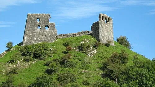
Dryslwyn Castle Natasha de Vere & Col Ford · CC BY 2.0

Climate of Felingwmuchaf
Best months for sightseeingBest months for sightseeing: June–September.
This month · November
A wet month
Day 11° · Night 6° · Rain 145 mm
- Hottest month
- July (day 19°)
- Coldest month
- February (night 3°)
- Wettest month
- November (145 mm)
- Driest month
- May (73 mm)
Bars: average monthly low and high temperature. Below: precipitation. Monthly averages for 1970–2000 at about 18 km resolution, adjusted for elevation. Highlighted months are mild and relatively dry. Source: WorldClim 2.1 (CC BY 4.0).
Show values as a table
| Month | Jan | Feb | Mar | Apr | May | Jun | Jul | Aug | Sep | Oct | Nov | Dec |
|---|---|---|---|---|---|---|---|---|---|---|---|---|
| Average high (°C) | 8° | 7° | 9° | 12° | 15° | 17° | 19° | 19° | 17° | 14° | 11° | 9° |
| Average low (°C) | 3° | 3° | 4° | 5° | 8° | 10° | 13° | 13° | 11° | 9° | 6° | 4° |
| Precipitation (mm) | 133 | 94 | 104 | 76 | 73 | 82 | 81 | 100 | 108 | 134 | 145 | 139 |
Other places to visit in this season: June July August September
How to get to Felingwmuchaf
The nearest airport is Cardiff International Airport (CWL), 80 km to the southeast as the crow flies. The nearest large city is Swansea, 35 km to the southeast.
Airports
- Cardiff International Airport (CWL) Cardiff 80 kmsoutheast
- Bristol Airport (BRS) Bristol 116 kmsoutheast
- Exeter International Airport (EXT) Exeter, Devon 140 kmsouth
Nearby large cities
- Swansea Population: 300.4K 35 kmsoutheast
- Cardiff Population: 372.1K 83 kmsoutheast
- Newport Population: 161.5K 88 kmsoutheast
- Bristol Population: 479K 120 kmsoutheast
- Gloucester Population: 132.4K 133 kmeast
Straight-line distances; road distances are longer. Airport data: OurAirports.
Day trips from Felingwmuchaf
Within 100 km: 729 historic and cultural sites, 1,932 natural sites, 171 lakes, rivers and coasts.
0–25 km273 places
- Ynys Isaf Island 11 kmS
- Trichrug Mountain 19 kmE
- Mynydd Pen-bre Mountain 21 kmS
- Moelfre Mountain 22 kmNW
25–60 km904 places
- Poppit Sands Beach 43 kmNW
- Manorbier Beach Beach 52 kmSW
- Mwnt beach Beach 42 kmNW
- Tresaith Beach Beach 35 kmNW
60–100 km1,655 places
- St Justinian Natural site 79 kmW
- Porth Clais Natural site 77 kmW
- Port Selau Natural site 78 kmW
- Saunton Sands Beach 89 kmS
Straight-line distances.
Nearby attractions & nature
Everything nearby-
Allt Cwm-Perrot Mountain, Llanegwad0.9 km E
-
Allt Dan-ty-mawr Mountain, Llanegwad2.2 km SE
-
Allt y Ferin Historic site, Llanegwad1.9 km SE
-
Llethrau Lletty'r-gofid Mountain, Llanegwad2.4 km SE
-
Bryn-hawddgar Mountain, Abergwili3.1 km W
-
Abercothi Hill Mountain, Llanegwad3.8 km S
Sources & licences
Data last updated: