Banc Cefngarreg
Located in Llanfair-ar-y-Bryn, Carmarthenshire Coordinates: 52°01′58″ N 3°42′46″ W
- Elevation
- 314 m
- above sea level
- Local time
- UTC+00:00
- Europe/London · UTC+00:00
- Airports
- CWL Cardiff International Airport75 km
- BRS Bristol Airport100 km
About Banc Cefngarreg
Banc Cefngarreg is a mountain. Location: Llanfair-ar-y-Bryn, Carmarthenshire. Elevation: 314 m. The best months to visit are June–August. The nearest airport is Cardiff International Airport (75 km). Nearby sights include Noethgrug and Cefn.
Photos of Banc Cefngarreg
-
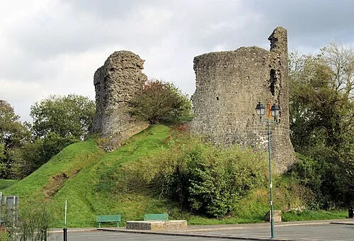
Llandovery Castle Stuart Logan · CC BY-SA 2.0

Climate of Banc Cefngarreg
Best months for sightseeingBest months for sightseeing: June–August.
This month · November
A wet month
Day 9° · Night 3° · Rain 182 mm
- Hottest month
- July (day 18°)
- Coldest month
- February (night 1°)
- Wettest month
- December (188 mm)
- Driest month
- May (86 mm)
Bars: average monthly low and high temperature. Below: precipitation. Monthly averages for 1970–2000 at about 18 km resolution, adjusted for elevation. Highlighted months are mild and relatively dry. Source: WorldClim 2.1 (CC BY 4.0).
Show values as a table
| Month | Jan | Feb | Mar | Apr | May | Jun | Jul | Aug | Sep | Oct | Nov | Dec |
|---|---|---|---|---|---|---|---|---|---|---|---|---|
| Average high (°C) | 6° | 6° | 8° | 10° | 14° | 16° | 18° | 18° | 15° | 12° | 9° | 7° |
| Average low (°C) | 1° | 1° | 2° | 3° | 6° | 8° | 10° | 10° | 8° | 6° | 3° | 2° |
| Precipitation (mm) | 182 | 127 | 139 | 98 | 86 | 96 | 92 | 116 | 131 | 162 | 182 | 188 |
How to get to Banc Cefngarreg
The nearest airport is Cardiff International Airport (CWL), 75 km to the south as the crow flies. The nearest large city is Swansea, 49 km to the south.
Airports
- Cardiff International Airport (CWL) Cardiff 75 kmsouth
- Bristol Airport (BRS) Bristol 100 kmsoutheast
- Birmingham Airport (BHX) Birmingham, West Midlands 142 kmeast
Nearby large cities
- Swansea Population: 300.4K 49 kmsouth
- Newport Population: 161.5K 70 kmsoutheast
- Cardiff Population: 372.1K 72 kmsoutheast
- Bristol Population: 479K 100 kmsoutheast
- Gloucester Population: 132.4K 103 kmeast
Straight-line distances; road distances are longer. Airport data: OurAirports.
Day trips from Banc Cefngarreg
Within 100 km: 964 historic and cultural sites, 2,433 natural sites, 176 lakes, rivers and coasts.
0–25 km325 places
- Dol-y-mynach Reservoir Lake 24 kmN
- Trichrug Mountain 20 kmSW
- Garn Gron Mountain 24 kmN
- Bryn Garw Mountain 22 kmN
25–60 km1,364 places
- Tresaith Beach Beach 56 kmW
- Llangrannog's Beach Beach 54 kmW
- Ynys Lochtyn Island 54 kmW
- Ynys Isaf Island 43 kmSW
60–100 km1,884 places
- Poppit Sands Beach 68 kmW
- Kilve Beach Beach 99 kmS
- Manorbier Beach Beach 87 kmSW
- Broad Haven South Beach Beach 96 kmSW
Straight-line distances.
Nearest towns and villages
-
Llanfair-ar-y-bryn Village, Llanfair-ar-y-Bryn2.2 km NW
-
Cynghordy Village, Llanfair-ar-y-Bryn2.3 km NW
-
 Llandovery Village, Llandovery7.2 km SW
-
Pentre-ty-gwyn Village, Llanfair-ar-y-Bryn3.3 km S
-
Pentrebach Village, Llanfair-ar-y-Bryn5.2 km S
-
 Llanwrtyd Wells Village, Llanwrtyd Wells9.6 km NE
Nearby attractions & nature
Everything nearby-
Noethgrug Mountain, Llanfair-ar-y-Bryn1.6 km SE
-
Cefn Mountain, Llanfair-ar-y-Bryn2.1 km W
-
Brynffo Mountain, Llanfair-ar-y-Bryn3 km NE
-
Cefn Blewog Mountain, Llanfair-ar-y-Bryn3 km E
-
Allt Mes Mountain, Llanfair-ar-y-Bryn3.2 km W
-
Mwmffri Mountain, Llanfair-ar-y-Bryn3.3 km SW
-
Allt Ystradwalter Mountain, Llanfair-ar-y-Bryn3.9 km SW
-
Clyn y Gwawr Mountain, Llanfair-ar-y-Bryn4.1 km N
Sources & licences
Data last updated: