Schilting
Located in Wolfsberg, Politischer Bezirk Wolfsberg Coordinates: 46°46′55″ N 14°52′22″ E
- Population
- 64
- 64
- Elevation
- 463 m
- above sea level
- Local time
- UTC+01:00
- Europe/Vienna · UTC+01:00
- Airports
- KLU Klagenfurt Airport44 km
- GRZ Graz Airport49 km
About Schilting
Schilting is a village. Location: Wolfsberg, Politischer Bezirk Wolfsberg. Population: 64. Elevation: 463 m. The best months to visit are May–September. The nearest airport is Klagenfurt Airport (44 km). Nearby sights include Unteres Lavanttal and Lavanttal-Arena.
Climate of Schilting
Best months for sightseeingBest months for sightseeing: May–September.
This month · November
A wet month
Day 8° · Night 1° · Rain 102 mm
- Hottest month
- July (day 25°)
- Coldest month
- January (night -5°)
- Wettest month
- July (147 mm)
- Driest month
- January (48 mm)
Bars: average monthly low and high temperature. Below: precipitation. Monthly averages for 1970–2000 at about 18 km resolution, adjusted for elevation. Highlighted months are mild and relatively dry. Source: WorldClim 2.1 (CC BY 4.0).
Show values as a table
| Month | Jan | Feb | Mar | Apr | May | Jun | Jul | Aug | Sep | Oct | Nov | Dec |
|---|---|---|---|---|---|---|---|---|---|---|---|---|
| Average high (°C) | 3° | 6° | 10° | 14° | 20° | 23° | 25° | 24° | 20° | 15° | 8° | 4° |
| Average low (°C) | -5° | -4° | 0° | 4° | 8° | 12° | 13° | 13° | 10° | 5° | 1° | -3° |
| Precipitation (mm) | 48 | 53 | 78 | 91 | 105 | 144 | 147 | 133 | 114 | 106 | 102 | 73 |
Other places to visit in this season: May June July August September
How to get to Schilting
The nearest airport is Klagenfurt Airport (KLU), 44 km to the west as the crow flies. The nearest large city is Klagenfurt, 47 km to the west.
Airports
- Klagenfurt Airport (KLU) Klagenfurt am Wörthersee 44 kmwest
- Graz Airport (GRZ) Feldkirchen bei Graz 49 kmnortheast
- Ljubljana Jože Pučnik Airport (LJU) Zgornji Brnik 70 kmsouthwest
Nearby large cities
- Klagenfurt Population: 100.3K 47 kmwest
- Graz Population: 303.3K 54 kmnortheast
- Zagreb Population: 663.6K 137 kmsoutheast
- Rijeka Population: 108K 165 kmsouth
- Linz Population: 204.8K 175 kmnorth
Straight-line distances; road distances are longer. Airport data: OurAirports.
Day trips from Schilting
Within 100 km: 260 historic and cultural sites, 1,555 natural sites, 602 lakes, rivers and coasts.
0–25 km125 places
- Raucheck Mountain 5 kmNE
- Moschkogel Mountain 10 kmNE
- Zoderkogel Mountain 6 kmN
- Wildbach Alpe Mountain 14 kmNE
25–60 km675 places
- Wildsee Lake 36 kmNW
- Wörthersee Lake 60 kmW
- Großer Winterleitensee Lake 42 kmNW
- Lake Turner Lake 32 kmSW
60–100 km1,617 places
- Klamm Natural site 92 kmNW
- Treffnersee Lake 87 kmN
- Glohbuckensee Lake 87 kmNW
- Gemeinsee Lake 84 kmNW
Straight-line distances.
Nearby attractions & nature
Everything nearby-
Unteres Lavanttal Natural site, Carinthia2.6 km NW
-
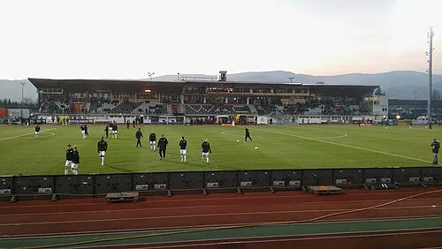 Lavanttal-Arena Landmark, Wolfsberg5.1 km N
-
Godinger Berg Mountain, St. Andrä4.6 km E
-
Kloster Maria Loreto Attraction, St. Andrä4 km W
-
Wois Bach River, Carinthia3.4 km W
-
Raucheck Mountain, Wolfsberg5.1 km NE
Sources & licences
Data last updated: