Geißbergen
Located in Scharndorf, Politischer Bezirk Bruck an der Leitha Coordinates: 48°05′00″ N 16°50′00″ E
- Elevation
- 156 m
- above sea level
- Local time
- UTC+01:00
- Europe/Vienna · UTC+01:00
- Airports
- VIE Vienna International Airport20 km
- BTS M. R. Štefánik Airport30 km
About Geißbergen
Geißbergen is a mountain. Location: Scharndorf, Politischer Bezirk Bruck an der Leitha. Elevation: 156 m. The best months to visit are May–September. The nearest airport is Vienna International Airport (20 km). Nearby sights include Goldberg and Schloss Harrach.
Photos of Geißbergen
-
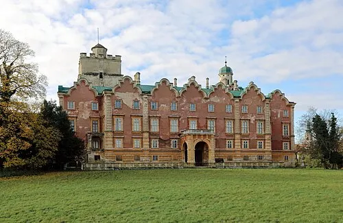
Schloß Prugg C.Stadler/Bwag · CC BY-SA 4.0 -
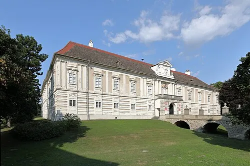
Schloss Harrach C.Stadler/Bwag · CC BY-SA 4.0


Climate of Geißbergen
Best months for sightseeingBest months for sightseeing: May–September.
This month · November
A cold month
Day 7° · Night 1° · Rain 50 mm
- Hottest month
- July (day 26°)
- Coldest month
- January (night -3°)
- Wettest month
- June (70 mm)
- Driest month
- January (33 mm)
Bars: average monthly low and high temperature. Below: precipitation. Monthly averages for 1970–2000 at about 18 km resolution, adjusted for elevation. Highlighted months are mild and relatively dry. Source: WorldClim 2.1 (CC BY 4.0).
Show values as a table
| Month | Jan | Feb | Mar | Apr | May | Jun | Jul | Aug | Sep | Oct | Nov | Dec |
|---|---|---|---|---|---|---|---|---|---|---|---|---|
| Average high (°C) | 3° | 5° | 10° | 15° | 21° | 24° | 26° | 26° | 21° | 15° | 7° | 4° |
| Average low (°C) | -3° | -3° | 1° | 5° | 10° | 13° | 15° | 14° | 11° | 6° | 1° | -2° |
| Precipitation (mm) | 33 | 33 | 37 | 47 | 61 | 70 | 69 | 61 | 55 | 41 | 50 | 40 |
Other places to visit in this season: May June July August September
How to get to Geißbergen
The nearest airport is Vienna International Airport (VIE), 20 km to the west as the crow flies. The nearest large city is Bratislava, 22 km to the east.
Airports
- Vienna International Airport (VIE) Vienna 20 kmwest
- M. R. Štefánik Airport (BTS) Bratislava 30 kmeast
- Brno-Tuřany Airport (BRQ) Brno 119 kmnorth
Nearby large cities
- Bratislava Population: 423.7K 22 kmeast
- Győr Population: 129.3K 75 kmsoutheast
- Brno Population: 404.3K 125 kmnorth
- Graz Population: 303.3K 154 kmsouthwest
- Székesfehérvár Population: 101.6K 155 kmsoutheast
Straight-line distances; road distances are longer. Airport data: OurAirports.
Day trips from Geißbergen
Within 100 km: 496 historic and cultural sites, 1,257 natural sites, 400 lakes, rivers and coasts.
0–25 km167 places
- Devínska Kobyla Mountain 17 kmNE
- Mirbach Palace Historic site 22 kmE
- Bratislava Castle Historic site 21 kmE
- Most SNP Landmark 21 kmE
25–60 km1,031 places
- Klokoč Mountain 56 kmNE
- Plavecký hrad Historic site 56 kmNE
- Ostrov Island 58 kmE
- Vysoká Mountain 47 kmNE
60–100 km955 places
- Záruby Mountain 64 kmNE
- Chvojnica River 86 kmN
- Túzokos Védett Terület Natural site 86 kmE
- Csicsói Holtág Védett Terület Natural site 76 kmSE
Straight-line distances.
Nearest towns and villages
-
Rohrau Municipality, Politischer Bezirk Bruck an der Leitha2.6 km SE
-
Scharndorf Village, Scharndorf2.8 km NW
-
Rohrau Village, Rohrau2.2 km SE
-
Wildungsmauer Village, Scharndorf3.5 km NW
-
Gerhaus Village, Rohrau3 km S
-
Petronell-Carnuntum Municipality, Politischer Bezirk Bruck an der Leitha3.9 km NE
Nearby attractions & nature
Everything nearby-
Goldberg Mountain, Scharndorf1.2 km W
-
Schloss Harrach Historic site, Rohrau2.7 km SE
-
Wechselbüheln Mountain, Rohrau3.9 km S
-
Wartberg Mountain, Höflein5 km W
-
Heidentor Historic site, Petronell-Carnuntum2.2 km NE
-
Königswald Natural site, Lower Austria5.6 km S
-
Oberer Heidenberg Mountain, Bruck an der Leitha6.2 km SW
-
Unterer Heidenberg Mountain, Bruck an der Leitha6.2 km SW
Sources & licences
Data last updated: