Oprtalj
Located in Municipality of Oprtalj - Portole, Istria County Coordinates: 45°22′54″ N 13°49′34″ E
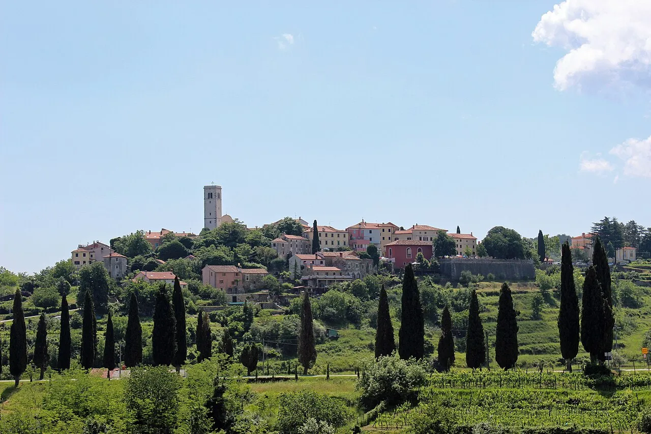
- Population
- 75
- 75
- Elevation
- 354 m
- above sea level
- Local time
- UTC+01:00
- Europe/Zagreb · UTC+01:00
- Airports
- PUY Pula Airport55 km
- TRS Trieste Airport57 km
About Oprtalj
Oprtalj is a city. Location: Municipality of Oprtalj - Portole, Istria County. Population: 75. Elevation: 354 m.
Oprtalj (Italian: Portole) is a village and municipality in Istria, Croatia. Oprtalj is a community in the central northern part of Istria County, situated across the Mirna river valley from the village of Motovun, about 20 km northwest of Pazin. Oprtalj used to be a fortress surrounded by walls. In front of the former door, there is a large Venetian loggia with a lapidary.
Source: Wikipedia · CC BY-SA 4.0
Photos of Oprtalj
-

Ulf Heinsohn · CC BY 3.0 -

Ulf Heinsohn · CC BY 3.0 -

Edelmauswaldgeist · CC0 -

G.F.S · CC BY 3.0 -

Maesi64 · CC0


Climate of Oprtalj
Best months for sightseeingBest months for sightseeing: May–September.
This month · November
A wet month
Day 12° · Night 5° · Rain 123 mm
- Hottest month
- August (day 26°)
- Coldest month
- January (night 0°)
- Wettest month
- October (124 mm)
- Driest month
- February (63 mm)
Bars: average monthly low and high temperature. Below: precipitation. Monthly averages for 1970–2000 at about 18 km resolution, adjusted for elevation. Highlighted months are mild and relatively dry. Source: WorldClim 2.1 (CC BY 4.0).
Show values as a table
| Month | Jan | Feb | Mar | Apr | May | Jun | Jul | Aug | Sep | Oct | Nov | Dec |
|---|---|---|---|---|---|---|---|---|---|---|---|---|
| Average high (°C) | 7° | 8° | 11° | 15° | 19° | 23° | 26° | 26° | 22° | 17° | 12° | 8° |
| Average low (°C) | 0° | 1° | 3° | 6° | 11° | 14° | 17° | 17° | 13° | 10° | 5° | 2° |
| Precipitation (mm) | 79 | 63 | 80 | 92 | 87 | 100 | 68 | 95 | 105 | 124 | 123 | 102 |
Other places to visit in this season: May June July August September
How to get to Oprtalj
The nearest airport is Pula Airport (PUY), 55 km to the south as the crow flies. The nearest large city is Rijeka, 49 km to the east.
Airports
- Pula Airport (PUY) Pula 55 kmsouth
- Trieste Airport (TRS) Ronchi dei Legionari/Trieste 57 kmnorthwest
- Rijeka Airport (RJK) Rijeka(Omišalj) 61 kmeast
Nearby large cities
- Rijeka Population: 108K 49 kmeast
- Ljubljana Population: 272.2K 91 kmnortheast
- Klagenfurt Population: 100.3K 143 kmnorth
- Zagreb Population: 663.6K 175 kmeast
- Graz Population: 303.3K 225 kmnortheast
Straight-line distances; road distances are longer. Airport data: OurAirports.
Day trips from Oprtalj
Within 100 km: 15 historic and cultural sites, 82 natural sites, 59 lakes, rivers and coasts.
0–25 km10 places
- Markovec Mountain 20 kmNW
- Slavnik Mountain 21 kmNE
- Rižana River 21 kmN
- Dragonja River 21 kmNW
25–60 km64 places
- Raša River 48 kmN
- Veliki Snežnik Mountain 55 kmNE
- Hrušica Mountain 59 kmNE
- Javorniki Mountain 53 kmNE
60–100 km82 places
- Krk Island 71 kmSE
- Lošinj Island 99 kmSE
- Uvala Stipanja Natural site 71 kmE
- Otočić Košljun Island 74 kmSE
Straight-line distances.
Nearby attractions & nature
Everything nearby-
 Rižana River, Slovenia21 km N
-
 Dragonja River, Slovenia21 km NW
-
Breg Mountain, Istria County12 km NW
-
Monte Zuccherino Mountain, Friuli Venezia Giulia23 km N
-
Monte d'Oro Mountain, San Dorligo della Valle-Dolina24 km N
-
Sveti Mihel Mountain, Muggia25 km N
-
Slavnik Mountain, Urban Municipality of Koper21 km NE
-
Markovec Mountain, Urban Municipality of Koper20 km NW
Sources & licences
Data last updated: · 2 independent sources