Vrgada
Located in Municipality of Pakoštane, Zadar County Coordinates: 43°51′22″ N 15°30′11″ E
- Population
- 209
- 209
- Elevation
- 19 m
- above sea level
- Local time
- UTC+01:00
- Europe/Zagreb · UTC+01:00
- Airports
- ZAD Zadar Airport29 km
- SPU Split Saint Jerome Airport73 km
About Vrgada
Vrgada is a village. Location: Municipality of Pakoštane, Zadar County. Population: 209. Elevation: 19 m.
Vrgada (Croatian pronunciation: [vř̩ɡaːda]) is an island off the coast of Croatia in the Adriatic Sea. It is located halfway between Zadar and Šibenik, in the archipelago northwest of Murter and south of Biograd na moru, 2.5 nautical miles (4.6 km) from the mainland. It has area of 3.7 square kilometres (1 square mile). and population of 249. The only settlement on the island is also named Vrgada and is surrounded with pine forest. Main industries are agriculture and fishing.
Source: Wikipedia · CC BY-SA 4.0
At a glance
- Area
- 3.7 km²
Source: Wikidata
Photos of Vrgada
-
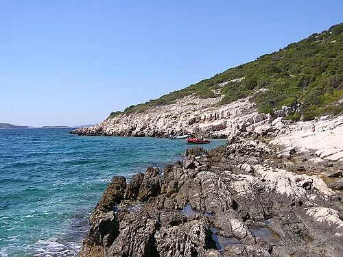
Arta Vela pepanos · CC BY 3.0 -
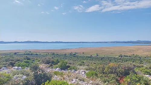
Lake Vrana Harald Hetzner · CC0


Climate of Vrgada
Best months for sightseeingBest months for sightseeing: May–June, September–October.
This month · November
Outside the best season
Day 14° · Night 6° · Rain 96 mm
- Hottest month
- July (day 30°)
- Coldest month
- January (night 3°)
- Wettest month
- November (96 mm)
- Driest month
- July (29 mm)
Bars: average monthly low and high temperature. Below: precipitation. Monthly averages for 1970–2000 at about 18 km resolution, adjusted for elevation. Highlighted months are mild and relatively dry. Source: WorldClim 2.1 (CC BY 4.0).
Show values as a table
| Month | Jan | Feb | Mar | Apr | May | Jun | Jul | Aug | Sep | Oct | Nov | Dec |
|---|---|---|---|---|---|---|---|---|---|---|---|---|
| Average high (°C) | 10° | 11° | 14° | 17° | 22° | 26° | 30° | 29° | 25° | 20° | 14° | 11° |
| Average low (°C) | 3° | 3° | 5° | 8° | 13° | 16° | 19° | 18° | 15° | 11° | 6° | 4° |
| Precipitation (mm) | 69 | 60 | 65 | 68 | 58 | 52 | 29 | 45 | 83 | 90 | 96 | 83 |
Other places to visit in this season: May June September October
How to get to Vrgada
The nearest airport is Zadar Airport (ZAD), 29 km to the northwest as the crow flies. The nearest large city is Split, 85 km to the southeast.
Airports
- Zadar Airport (ZAD) Zadar 29 kmnorthwest
- Split Saint Jerome Airport (SPU) Split 73 kmsoutheast
- Brač Airport (BWK) Gornji Humac 114 kmsoutheast
Nearby large cities
- Split Population: 149.8K 85 kmsoutheast
- Rijeka Population: 108K 184 kmnorthwest
- Zagreb Population: 663.6K 221 kmnorth
- Ljubljana Population: 272.2K 256 kmnorth
- Klagenfurt Population: 100.3K 322 kmnorth
Straight-line distances; road distances are longer. Airport data: OurAirports.
Day trips from Vrgada
Within 100 km: 10 historic and cultural sites, 15 natural sites, 61 lakes, rivers and coasts.
0–25 km18 places
- Otok Kaprije Island 24 kmSE
- Kornat Island 16 kmW
- Otok Žut Island 16 kmW
- Otok Vrgada Island 1 kmS
25–60 km34 places
- Otok Prvić Island 27 kmSE
- Otok Zlarin Island 33 kmSE
- Krapanj Island 39 kmSE
- Zuri Island Island 26 kmSE
60–100 km34 places
- Šolta Island 83 kmSE
- Silba Island 87 kmNW
- Otok Mali Drvenik Island 65 kmSE
- Birovača Mountain 89 kmNE
Straight-line distances.
Nearby attractions & nature
Everything nearby-
Otok Vrgada Island, Zadar County0.3 km S
-
Arta Vela Island, Šibenik-Knin County3.5 km E
-
Lake Vrana Lake, Zadar County7.5 km NE
-
 Otok Murter Island, Šibenik-Knin County11 km SE
-
 Otok Žut Island, Šibenik-Knin County16 km W
-
 Kornat Island, Municipality of Murter-Kornati16 km W
Sources & licences
Data last updated: · 2 independent sources