- Local time
- UTC+01:00
- Europe/Paris · UTC+01:00
- Elevation
- 789 m
- above sea level
- Airports
- CMF Chambéry Aix les Bains airport53 km
- NCY Annecy Meythet airport72 km
About Tour de Bérold
Tour de Bérold is a landmark. Location: Auvergne-Rhône-Alpes, France. The best months to visit are June–September. The nearest airport is Chambéry Aix les Bains airport (53 km). Nearby sights include Saint-Jean-de-Maurienne Cathedral and Saint-Jean-de-Maurienne (Convent).
Photos of Tour de Bérold
-
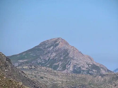
Grand Perron des Encombres Rémih · CC BY-SA 4.0

Climate of Tour de Bérold
Best months for sightseeingBest months for sightseeing: June–September.
This month · November
A wet month
Day 10° · Night 3° · Rain 141 mm
- Hottest month
- August (day 25°)
- Coldest month
- January (night -1°)
- Wettest month
- November (141 mm)
- Driest month
- July (75 mm)
Bars: average monthly low and high temperature. Below: precipitation. Monthly averages for 1970–2000 at about 18 km resolution, adjusted for elevation. Highlighted months are mild and relatively dry. Source: WorldClim 2.1 (CC BY 4.0).
Show values as a table
| Month | Jan | Feb | Mar | Apr | May | Jun | Jul | Aug | Sep | Oct | Nov | Dec |
|---|---|---|---|---|---|---|---|---|---|---|---|---|
| Average high (°C) | 6° | 7° | 9° | 12° | 18° | 21° | 25° | 25° | 21° | 16° | 10° | 7° |
| Average low (°C) | -1° | -1° | 1° | 4° | 8° | 11° | 14° | 14° | 11° | 7° | 3° | 0° |
| Precipitation (mm) | 121 | 114 | 104 | 103 | 110 | 100 | 75 | 86 | 98 | 125 | 141 | 132 |
Other places to visit in this season: June July August September
How to get to Tour de Bérold
The nearest airport is Chambéry Aix les Bains airport (CMF), 53 km to the northwest as the crow flies. The nearest large city is Grenoble, 52 km to the west.
Airports
- Chambéry Aix les Bains airport (CMF) Chambéry 53 kmnorthwest
- Annecy Meythet airport (NCY) Annecy 72 kmnorth
- Grenoble Alpes Isère Airport (GNB) Grenoble 81 kmwest
Nearby large cities
- Grenoble Population: 158.6K 52 kmwest
- Geneva Population: 201.7K 101 kmnorth
- Villeurbanne Population: 131.4K 127 kmnorthwest
- Lyon Population: 520.8K 128 kmnorthwest
- Lausanne Population: 139.1K 136 kmnorth
Straight-line distances; road distances are longer. Airport data: OurAirports.
Day trips from Tour de Bérold
Within 100 km: 106 historic and cultural sites, 1,826 natural sites, 323 lakes, rivers and coasts.
0–25 km211 places
- Lac de la Motte Lake 22 kmW
- Le Grand Lac (Lac Bramant) Lake 18 kmSW
- Lac Cottepens Lake 23 kmW
- Lac du Cos Lake 23 kmW
25–60 km746 places
- Lac Mort Lake 54 kmSW
- St Alban Plage Beach 53 kmNW
- Grande Île Island 52 kmNW
- Petite Île Island 52 kmNW
60–100 km1,298 places
- Lac d'Émosson Lake 97 kmNE
- Lac d'Orny Lake 95 kmNE
- Lac de la Breye Lake 97 kmNE
- Lac du Dru Lake 96 kmNE
Straight-line distances.
Nearby attractions & nature
Everything nearby-
Saint-Jean-de-Maurienne Cathedral Attraction, Saint-Jean-de-Maurienne3.2 km S
-
Saint-Jean-de-Maurienne (Convent) Historic site, Saint-Jean-de-Maurienne3.3 km S
-
Forêt du Sapey Natural site, Savoy2.1 km W
-
Crêt du Carollier Mountain, La Tour-en-Maurienne3.2 km NE
-
Cime de Lancheton Mountain, La Tour-en-Maurienne3.9 km E
-
Pointe du Télégraphe Mountain, Saint-Julien-Mont-Denis3.4 km SE
-
le Coin du Châtel Mountain, La Tour-en-Maurienne4.2 km NE
-
L'Armélaz Mountain, La Tour-en-Maurienne4.3 km N
Nearest towns and villages
-
La Tour-en-Maurienne Village, Arrondissement of Saint-Jean-de-Maurienne0.6 km S
-
Hermillon Village, La Tour-en-Maurienne0.7 km S
-
Saint-Jean-de-Maurienne Village, Arrondissement of Saint-Jean-de-Maurienne3.2 km S
-
Montvernier Village, Arrondissement of Saint-Jean-de-Maurienne2.3 km NW
More sights in Auvergne-Rhône-Alpes
-
Fort du Télégraphe Historic site, Saint-Martin-d'Arc12 km SE
-
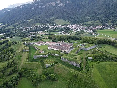 Fort Barraux Historic site, Barraux33 km NW
-
Chartreuse de Saint-Hugon Historic site, Arvillard21 km NW
-
Fort de Montgilbert Historic site, Montgilbert25 km N
-
Fort du Sappey Historic site, Modane26 km SE
-
Fort du Replaton Historic site, Modane26 km SE
Sources & licences
Data last updated: