Sommand
Located in Upper Savoy, Auvergne-Rhône-Alpes Coordinates: 46°09′41″ N 6°33′22″ E
- Elevation
- 1,500 m
- above sea level
- Local time
- UTC+01:00
- Europe/Paris · UTC+01:00
- Airports
- GVA Geneva International Airport36 km
- NCY Annecy Meythet airport44 km
About Sommand
Sommand is a natural site. Location: Upper Savoy, Auvergne-Rhône-Alpes. The best months to visit are July–August. The nearest airport is Geneva International Airport (36 km). Nearby sights include Pierre Rouge and Pointe de Rovagne.
Photos of Sommand
-
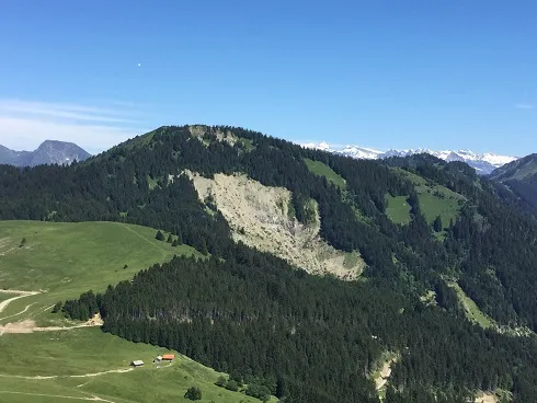
Pointe de la Gay Fachimiar · CC BY-SA 4.0 -
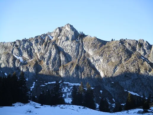
Pointe de Chavannais Fachimiar · CC BY-SA 4.0


Climate of Sommand
Best months for sightseeingBest months for sightseeing: July–August.
This month · November
A wet month
Day 3° · Night -4° · Rain 123 mm
- Hottest month
- July (day 19°)
- Coldest month
- January (night -7°)
- Wettest month
- December (126 mm)
- Driest month
- April (88 mm)
Bars: average monthly low and high temperature. Below: precipitation. Monthly averages for 1970–2000 at about 18 km resolution, adjusted for elevation. Highlighted months are mild and relatively dry. Source: WorldClim 2.1 (CC BY 4.0).
Show values as a table
| Month | Jan | Feb | Mar | Apr | May | Jun | Jul | Aug | Sep | Oct | Nov | Dec |
|---|---|---|---|---|---|---|---|---|---|---|---|---|
| Average high (°C) | -1° | 1° | 4° | 7° | 12° | 16° | 19° | 19° | 15° | 9° | 3° | 0° |
| Average low (°C) | -7° | -7° | -5° | -2° | 3° | 5° | 8° | 8° | 5° | 1° | -4° | -6° |
| Precipitation (mm) | 113 | 116 | 94 | 88 | 100 | 115 | 96 | 95 | 99 | 111 | 123 | 126 |
How to get to Sommand
The nearest airport is Geneva International Airport (GVA), 36 km to the west as the crow flies. The nearest large city is Geneva, 32 km to the west.
Airports
- Geneva International Airport (GVA) Geneva 36 kmwest
- Annecy Meythet airport (NCY) Annecy 44 kmsouthwest
- Chambéry Aix les Bains airport (CMF) Chambéry 78 kmsouthwest
Nearby large cities
- Geneva Population: 201.7K 32 kmwest
- Lausanne Population: 139.1K 40 kmnorth
- Bern Population: 121.6K 111 kmnortheast
- Grenoble Population: 158.6K 127 kmsouthwest
- Besançon Population: 128.4K 128 kmnorth
Straight-line distances; road distances are longer. Airport data: OurAirports.
Day trips from Sommand
Within 100 km: 145 historic and cultural sites, 3,020 natural sites, 454 lakes, rivers and coasts.
0–25 km236 places
- Lac de Morgins Lake 24 kmNE
- Lac Vert Lake 20 kmE
- Lac de Chésery Lake 20 kmE
- Mont Sagerou Mountain 23 kmE
25–60 km1,286 places
- Ile de Salagnon Island 40 kmNE
- Lac de Joux Lake 57 kmN
- Lake Leman Lake 31 kmN
- Lac de Fully Lake 42 kmE
60–100 km2,097 places
- Ile d'Ogoz Island 73 kmNE
- Schwarzsee Lake 79 kmNE
- Oeschinen Lake Lake 98 kmNE
- Lake Neuchâtel Lake 88 kmN
Straight-line distances.
Nearest towns and villages
Nearby attractions & nature
Everything nearby-
Pierre Rouge Mountain, Mieussy1.2 km NE
-
Pointe de Rovagne Mountain, Mieussy1.3 km W
-
Pointe de Verand Mountain, Taninges1.5 km SE
-
Pointe de Chavannais Mountain, Mieussy2 km N
-
Pointe du Velard Mountain, Taninges1.6 km S
-
Hautepointe Mountain, Mieussy1.6 km N
-
Pointe du Haut Fleuri Mountain, Taninges1.7 km S
-
Haute Pointe Mountain, Mieussy1.7 km N
Sources & licences
Data last updated: · 2 independent sources