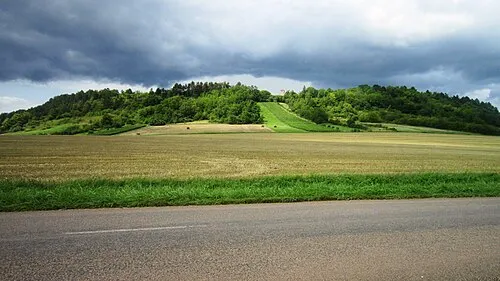
Bois du Charmois
Located in Cote d'Or, Bourgogne-Franche-Comté Coordinates: 48°01′24″ N 4°35′58″ E
- Elevation
- 272 m
- above sea level
- Local time
- UTC+01:00
- Europe/Paris · UTC+01:00
- Airports
- XCR Chalons Vatry airport88 km
- DLE Dole Tavaux Airport126 km
About Bois du Charmois
Bois du Charmois is a natural site. Location: Cote d'Or, Bourgogne-Franche-Comté. The best months to visit are June–September. The nearest airport is Chalons Vatry airport (88 km). Nearby sights include Bois du Charmis and Bois Oisellemont.
Climate of Bois du Charmois
Best months for sightseeingBest months for sightseeing: June–September.
This month · November
A cold month
Day 9° · Night 2° · Rain 74 mm
- Hottest month
- August (day 24°)
- Coldest month
- February (night -1°)
- Wettest month
- December (82 mm)
- Driest month
- April (58 mm)
Bars: average monthly low and high temperature. Below: precipitation. Monthly averages for 1970–2000 at about 18 km resolution, adjusted for elevation. Highlighted months are mild and relatively dry. Source: WorldClim 2.1 (CC BY 4.0).
Show values as a table
| Month | Jan | Feb | Mar | Apr | May | Jun | Jul | Aug | Sep | Oct | Nov | Dec |
|---|---|---|---|---|---|---|---|---|---|---|---|---|
| Average high (°C) | 5° | 7° | 10° | 13° | 18° | 20° | 24° | 24° | 19° | 15° | 9° | 6° |
| Average low (°C) | -1° | -1° | 2° | 4° | 7° | 10° | 13° | 12° | 9° | 7° | 2° | 0° |
| Precipitation (mm) | 77 | 71 | 61 | 58 | 79 | 77 | 60 | 66 | 71 | 73 | 74 | 82 |
Other places to visit in this season: June July August September
How to get to Bois du Charmois
The nearest airport is Chalons Vatry airport (XCR), 88 km to the north as the crow flies. The nearest large city is Dijon, 85 km to the south.
Airports
- Chalons Vatry airport (XCR) Chalons en Champagne 88 kmnorth
- Dole Tavaux Airport (DLE) Dole 126 kmsoutheast
- Metz-Nancy-Lorraine Airport (ETZ) Goin 162 kmnortheast
Nearby large cities
- Dijon Population: 159.9K 85 kmsouth
- Besançon Population: 128.4K 137 kmsoutheast
- Nancy Population: 105.1K 139 kmnortheast
- Reims Population: 196.6K 144 kmnorth
- Metz Population: 123.9K 168 kmnortheast
Straight-line distances; road distances are longer. Airport data: OurAirports.
Day trips from Bois du Charmois
Within 100 km: 153 historic and cultural sites, 583 natural sites, 169 lakes, rivers and coasts.
0–25 km76 places
- Étang de Marcenay Lake 22 kmSW
- Étang Bailly Lake 21 kmSW
- Mont Remin Mountain 19 kmE
- Bois du Roi Natural site 12 kmW
25–60 km353 places
- Étang de Ramerupt Lake 35 kmN
- Étang du Parc aux Pourceaux Lake 30 kmNW
- Réservoir de la Mouche Lake 52 kmE
- Étang de la Morge des Champs Lake 34 kmNW
60–100 km476 places
- Le Vieil Lake 91 kmN
- Réservoir de Villegusien Lake 62 kmSE
- Étang Richebourg Lake 67 kmN
- Étang Neuf Lake 92 kmN
Straight-line distances.
Nearest towns and villages
-
Grancey-sur-Ource Village, Arrondissement de Montbard1.9 km SW
-
Grancey-sur-Ource Village, Grancey-sur-Ource2 km SW
-
Verpillières-sur-Ource Village, Arrondissement of Troyes3 km NW
-
Autricourt Village, Arrondissement de Montbard3.2 km SE
-
Verpillières-sur-Ource Village, Verpillières-sur-Ource3 km NW
-
Autricourt Village, Autricourt3.2 km SE
Nearby attractions & nature
Everything nearby-
Bois du Charmis Natural site, Cote d'Or2.2 km W
-
Bois Oisellemont Natural site, Grand Est2.9 km NE
-
Bois de Frasse Natural site, Cote d'Or4.1 km S
-
Bois de Réveillon Natural site, Bourgogne-Franche-Comté4.5 km SW
-
Ruisseau de Bedan River, Cote d'Or2.9 km SE
-
Bois de Ceulx Natural site, Aube5 km W
-
Bois de Foucherolle Natural site, Aube5.8 km NW
-
Forêt Lambert Natural site, Grand Est5.9 km E
More nature in France
-
Bois des Forts Natural site, Cote d'Or6.2 km E
-
Forêt Domaniale de Val du Puits Natural site, Cote d'Or6.3 km S
-
Bois de la Tête au Loup Natural site, Cote d'Or6.5 km S
-
 Mont Lassois Mountain, Vix14 km S
-
Bois Lainoire Natural site, Cote d'Or6.8 km S
-
Bois Jouard Natural site, Cote d'Or8.2 km S
Sources & licences
Data last updated: