Arrondissement of Quimper
Located in Finistère, Brittany Region Coordinates: 47°57′57″ N 4°00′11″ W
- Population
- 331,722
- 331.7K
- Elevation
- 92 m
- above sea level
- Local time
- UTC+01:00
- Europe/Paris · UTC+01:00
- Places inside
- 85
- listed under Arrondissement of Quimper
- Airports
- BES Brest Bretagne airport62 km
- RNS Rennes-Saint-Jacques Airport170 km
About Arrondissement of Quimper
Arrondissement of Quimper is a municipality. Location: Finistère, Brittany Region. Population: 331,722. Elevation: 92 m. The best months to visit are June–August. The nearest airport is Brest Bretagne airport (62 km). Nearby sights include Bois du Mur and Bois de Pleuven.
Photos of Arrondissement of Quimper
-
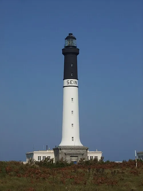
Grand Phare de l'Île de Sein Pyrite · Public domain -
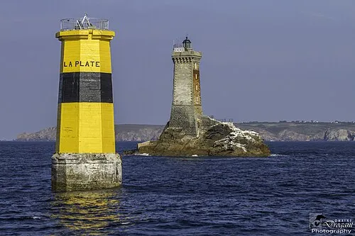
Tourelle de la Plate Jean-Jacques Abalain from Melgven · CC BY 2.0


Climate of Arrondissement of Quimper
Best months for sightseeingBest months for sightseeing: June–August.
This month · November
A wet month
Day 12° · Night 7° · Rain 133 mm
- Hottest month
- August (day 21°)
- Coldest month
- February (night 4°)
- Wettest month
- November (133 mm)
- Driest month
- July (44 mm)
Bars: average monthly low and high temperature. Below: precipitation. Monthly averages for 1970–2000 at about 18 km resolution, adjusted for elevation. Highlighted months are mild and relatively dry. Source: WorldClim 2.1 (CC BY 4.0).
Show values as a table
| Month | Jan | Feb | Mar | Apr | May | Jun | Jul | Aug | Sep | Oct | Nov | Dec |
|---|---|---|---|---|---|---|---|---|---|---|---|---|
| Average high (°C) | 9° | 9° | 11° | 13° | 16° | 19° | 21° | 21° | 19° | 15° | 12° | 10° |
| Average low (°C) | 4° | 4° | 5° | 6° | 9° | 12° | 14° | 14° | 12° | 10° | 7° | 5° |
| Precipitation (mm) | 126 | 97 | 86 | 66 | 72 | 53 | 44 | 59 | 78 | 91 | 133 | 122 |
How to get to Arrondissement of Quimper
The nearest airport is Brest Bretagne airport (BES), 62 km to the northwest as the crow flies. The nearest large city is Brest, 59 km to the northwest.
Airports
- Brest Bretagne airport (BES) Brest 62 kmnorthwest
- Rennes-Saint-Jacques Airport (RNS) Saint-Jacques-de-la-Lande, Ille-et-Vilaine 170 kmeast
- Jersey Airport (JER) St. Peter 192 kmnortheast
Nearby large cities
- Brest Population: 144.9K 59 kmnorthwest
- Rennes Population: 227.8K 174 kmeast
- Nantes Population: 325.1K 202 kmsoutheast
- Angers Population: 168.3K 265 kmeast
- Plymouth Population: 260.2K 268 kmnorth
Straight-line distances; road distances are longer. Airport data: OurAirports.
Day trips from Arrondissement of Quimper
Within 100 km: 276 historic and cultural sites, 141 natural sites, 274 lakes, rivers and coasts.
0–25 km61 places
- Moros River 12 kmSE
- Plages de Trévignon Beach 19 kmSE
- Île Garo Island 19 kmSW
- Roch Veur Mountain 17 kmN
25–60 km234 places
- Île de Groix Island 55 kmSE
- Plage de Kerguélen Beach 54 kmSE
- Plage de Toulhars Beach 55 kmSE
- Plage de Larmor Beach 55 kmSE
60–100 km396 places
- Belle Île Island 93 kmSE
- Île Grande Island 98 kmN
- Kastell Koad Freg Historic site 93 kmNE
- Kastell Tonkedeg Historic site 90 kmNE
Straight-line distances.
Arrondissement of Quimper and similar cities
Side by side with cities of similar size in the same country: population, elevation and climate.
| Measure | Arrondissement of Quimper | Nantes | Nice | Marne La Vallée |
|---|---|---|---|---|
| Population | 331.7K | 325.1K | 342.7K | 318.3K |
| Elevation | 92 m | 19 m | 25 m | 96 m |
| Summer day (hottest month) | 21° | 25° | 28° | 24° |
| Winter night (coldest month) | 4° | 3° | 5° | 1° |
| Annual rainfall | 1,027 mm | 794 mm | 807 mm | 635 mm |
| Best months | Jun–Aug | Jun–Sep | May–Sep | Jun–Sep |
| Distance | — | 202 km | 994 km | 501 km |
Climate values are 1970–2000 monthly averages; straight-line distance.
Places in Arrondissement of Quimper
85 places- 1 Quimper 63.4K
- 2 Concarneau 19K
- 3 Douarnenez 14.1K
- 4 Quimperlé 12K
- 5 Fouesnant 9.5K
- 6 Pont-l'Abbé 8.2K
- 7 Ergué-Gabéric 8.1K
- 8 Rosporden 7.6K
- 9 Trégunc 7K
- 10 Moëlan-sur-Mer 6.8K
- 11 Plonéour-Lanvern 6.1K
- 12 Bannalec 5.6K
- 13 Briec 5.6K
- 14 Scaër 5.4K
- 15 Penmarch 5.4K
- 16 Clohars-Carnoët 4.3K
- 17 Riec-sur-Bélon 4.2K
- 18 Plomelin 4.2K
- 19 Pluguffan 4.1K
- 20 Loctudy 4.1K
- 21 Combrit 4K
- 22 Plouhinec 4K
- 23 Plomeur 3.8K
- 24 Audierne 3.7K
- 25 Saint-Évarzec 3.5K
- 26 Bénodet 3.5K
- 27 Plobannalec-Lesconil 3.5K
- 28 Melgven 3.4K
- 29 La Forêt-Fouesnant 3.3K
- 30 Elliant 3.2K
- 31 Plogonnec 3.1K
- 32 Saint-Yvi 3.1K
- 33 Mellac 3K
- 34 Plozévet 3K
- 35 Rédené 2.9K
- 36 Pleuven 2.8K
- 37 Pont-Aven 2.8K
- 38 Gouesnach 2.8K
- 39 Guilvinec 2.7K
- 40 Nevez 2.6K
- 41 Treffiagat 2.4K
- 42 Plonéis 2.4K
- 43 Tréméven 2.3K
- 44 Edern 2.2K
- 45 Pouldreuzic 2.1K
- 46 Clohars-Fouesnant 2K
- 47 Plogastel-Saint-Germain 1.9K
- 48 Landrévarzec 1.8K
- 49 Guengat 1.8K
- 50 Querrien 1.7K
- 51 Le Trévoux 1.6K
- 52 Pont-Croix 1.6K
- 53 Poullan-sur-Mer 1.5K
- 54 Landudec 1.4K
- 55 Arzano 1.4K
- 56 Tréméoc 1.3K
- 57 Plogoff 1.2K
- 58 Pouldergat 1.2K
- 59 Locunolé 1.2K
- 60 Baye 1.1K
Bar: population relative to the most populous place in this list.
Nearby attractions & nature
Everything nearby-
Bois du Mur Natural site, Finistère1.9 km S
-
Bois de Pleuven Natural site, Finistère3.2 km SE
-
Jet River, Finistère7.2 km E
-
Steir River, Finistère8.2 km NW
-
Odet River, Finistère13 km SW
-
Bois de Goarlot Natural site, Finistère18 km E
-
Forêt du Duc Natural site, Finistère20 km NW
-
Île Chevalier Island, Brittany Region18 km SW
Sources & licences
Data last updated: