- Population
- 129,260
- 129.3K
- Elevation
- 322 m
- above sea level
- Local time
- UTC+01:00
- Europe/Paris · UTC+01:00
- Places inside
- 162
- listed under Arrondissement of Saverne
- Airports
- SXB Strasbourg Airport39 km
- SCN Saarbrücken Airport45 km
About Arrondissement of Saverne
Arrondissement of Saverne is a municipality. Location: Bas-Rhin, Grand Est. Population: 129,260. Elevation: 322 m. The best months to visit are June–August. The nearest airport is Strasbourg Airport (39 km). Nearby sights include Bois du Breitschloss and Château de Lützelstein.
Photos of Arrondissement of Saverne
-
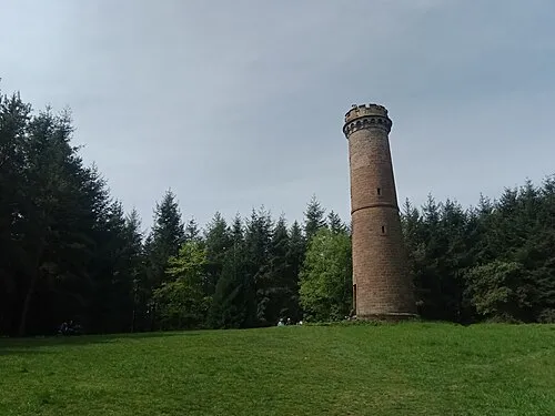
Brotschberg Rémih · CC BY-SA 4.0

Climate of Arrondissement of Saverne
Best months for sightseeingBest months for sightseeing: June–August.
This month · November
A cold month
Day 7° · Night 1° · Rain 75 mm
- Hottest month
- July (day 23°)
- Coldest month
- January (night -2°)
- Wettest month
- June (81 mm)
- Driest month
- April (56 mm)
Bars: average monthly low and high temperature. Below: precipitation. Monthly averages for 1970–2000 at about 18 km resolution, adjusted for elevation. Highlighted months are mild and relatively dry. Source: WorldClim 2.1 (CC BY 4.0).
Show values as a table
| Month | Jan | Feb | Mar | Apr | May | Jun | Jul | Aug | Sep | Oct | Nov | Dec |
|---|---|---|---|---|---|---|---|---|---|---|---|---|
| Average high (°C) | 3° | 5° | 9° | 13° | 18° | 21° | 23° | 23° | 18° | 13° | 7° | 5° |
| Average low (°C) | -2° | -2° | 1° | 3° | 8° | 11° | 12° | 12° | 9° | 5° | 1° | 0° |
| Precipitation (mm) | 61 | 60 | 58 | 56 | 80 | 81 | 71 | 60 | 67 | 75 | 75 | 81 |
How to get to Arrondissement of Saverne
The nearest airport is Strasbourg Airport (SXB), 39 km to the southeast as the crow flies. The nearest large city is Strasbourg, 40 km to the southeast.
Airports
- Strasbourg Airport (SXB) Strasbourg 39 kmsoutheast
- Saarbrücken Airport (SCN) Saarbrücken 45 kmnorthwest
- Karlsruhe Baden-Baden Airport (FKB) Rheinmünster 53 kmeast
Nearby large cities
- Strasbourg Population: 274.8K 40 kmsoutheast
- Saarbrücken Population: 183K 50 kmnorthwest
- Karlsruhe Population: 283.8K 78 kmeast
- Nancy Population: 105.1K 89 kmwest
- Metz Population: 123.9K 93 kmwest
Straight-line distances; road distances are longer. Airport data: OurAirports.
Day trips from Arrondissement of Saverne
Within 100 km: 437 historic and cultural sites, 2,700 natural sites, 553 lakes, rivers and coasts.
0–25 km175 places
- Lac de Hasselfurt Lake 22 kmN
- Étang de Hanau Lake 22 kmNE
- le Blohn Mountain 15 kmNE
- Schlossberg Mountain 18 kmS
25–60 km957 places
- Unditz River 57 kmSE
- Rench River 49 kmE
- Matschelsee Lake 59 kmSE
- Zwieselkopf Mountain 59 kmNE
60–100 km2,558 places
- Insel Flotzgrün Island 92 kmNE
- Mummelsee Lake 67 kmSE
- Huzenbacher See Lake 78 kmE
- Glaswaldsee Lake 81 kmSE
Straight-line distances.
Arrondissement of Saverne and similar cities
Side by side with cities of similar size in the same country: population, elevation and climate.
| Measure | Arrondissement of Saverne | Besançon | Villeurbanne | Metz |
|---|---|---|---|---|
| Population | 129.3K | 128.4K | 131.4K | 123.9K |
| Elevation | 322 m | 300 m | 177 m | 182 m |
| Summer day (hottest month) | 23° | 24° | 27° | 25° |
| Winter night (coldest month) | -2° | -1° | 0° | -1° |
| Annual rainfall | 825 mm | 1,156 mm | 844 mm | 776 mm |
| Best months | Jun–Aug | Jun–Sep | May–Sep | May–Sep |
| Distance | — | 204 km | 390 km | 93 km |
Climate values are 1970–2000 monthly averages; straight-line distance.
Places in Arrondissement of Saverne
162 places- 121 Domfessel 290
- 122 Dossenheim-Kochersberg 285
- 123 Littenheim 284
- 124 Eywiller 283
- 125 Asswiller 282
- 126 Bischholtz 280
- 127 Gungwiller 280
- 128 Handschuheim 274
- 129 Burbach 271
- 130 Buswiller 271
- 131 Westhouse-Marmoutier 271
- 132 Tieffenbach 267
- 133 Niedersoultzbach 265
- 134 Hohfrankenheim 260
- 135 Ottwiller 260
- 136 Ratzwiller 253
- 137 Grassendorf 249
- 138 Struth 247
- 139 Zittersheim 245
- 140 Sparsbach 244
- 141 Friedolsheim 239
- 142 Gœrlingen 238
- 143 Lorentzen 238
- 144 Maennolsheim 232
- 145 Altenheim 210
- 146 Rauwiller 208
- 147 Rexingen 204
- 148 Landersheim 203
- 149 Printzheim 201
- 150 Hengwiller 188
- 151 Eschwiller 183
- 152 Frohmuhl 183
- 153 Thal-Drulingen 183
- 154 Kirrberg 168
- 155 Bosselshausen 162
- 156 Uttwiller 161
- 157 Bissert 156
- 158 Kleingœft 156
- 159 Scherlenheim 128
- 160 Hinsbourg 113
- 161 Issenhausen 108
- 162 Hinsingen 89
Bar: population relative to the most populous place in this list.
Nearby attractions & nature
Everything nearby-
Bois du Breitschloss Natural site, Bas-Rhin4.6 km SW
-
Château de Lützelstein Historic site, Grand Est4.1 km W
-
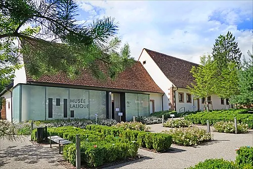 Musée Lalique Museum, Grand Est9.1 km N
-
Forêt Domaniale de la Petite-Pierre Sud Natural site, Bas-Rhin7.7 km SW
-
Chapelle Saint-Michel Attraction, Grand Est7.7 km S
-
Forêt Domaniale d'Ingwiller Natural site, Bas-Rhin10 km NE
-
Zintzel du Sud River, Bas-Rhin9.8 km SE
-
Forêt Domaniale de la Petite-Pierre Nord Natural site, Bas-Rhin11 km NW
Sources & licences
Data last updated: