- Population
- 129,260
- 129.3K
- Elevation
- 322 m
- above sea level
- Local time
- UTC+01:00
- Europe/Paris · UTC+01:00
- Places inside
- 162
- listed under Arrondissement of Saverne
- Airports
- SXB Strasbourg Airport39 km
- SCN Saarbrücken Airport45 km
About Arrondissement of Saverne
Arrondissement of Saverne is a municipality. Location: Bas-Rhin, Grand Est. Population: 129,260. Elevation: 322 m. The best months to visit are June–August. The nearest airport is Strasbourg Airport (39 km). Nearby sights include Bois du Breitschloss and Château de Lützelstein.
Photos of Arrondissement of Saverne
-
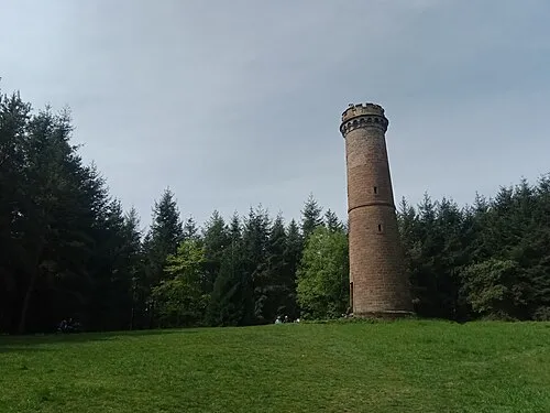
Brotschberg Rémih · CC BY-SA 4.0

Climate of Arrondissement of Saverne
Best months for sightseeingBest months for sightseeing: June–August.
This month · November
A cold month
Day 7° · Night 1° · Rain 75 mm
- Hottest month
- July (day 23°)
- Coldest month
- January (night -2°)
- Wettest month
- June (81 mm)
- Driest month
- April (56 mm)
Bars: average monthly low and high temperature. Below: precipitation. Monthly averages for 1970–2000 at about 18 km resolution, adjusted for elevation. Highlighted months are mild and relatively dry. Source: WorldClim 2.1 (CC BY 4.0).
Show values as a table
| Month | Jan | Feb | Mar | Apr | May | Jun | Jul | Aug | Sep | Oct | Nov | Dec |
|---|---|---|---|---|---|---|---|---|---|---|---|---|
| Average high (°C) | 3° | 5° | 9° | 13° | 18° | 21° | 23° | 23° | 18° | 13° | 7° | 5° |
| Average low (°C) | -2° | -2° | 1° | 3° | 8° | 11° | 12° | 12° | 9° | 5° | 1° | 0° |
| Precipitation (mm) | 61 | 60 | 58 | 56 | 80 | 81 | 71 | 60 | 67 | 75 | 75 | 81 |
How to get to Arrondissement of Saverne
The nearest airport is Strasbourg Airport (SXB), 39 km to the southeast as the crow flies. The nearest large city is Strasbourg, 40 km to the southeast.
Airports
- Strasbourg Airport (SXB) Strasbourg 39 kmsoutheast
- Saarbrücken Airport (SCN) Saarbrücken 45 kmnorthwest
- Karlsruhe Baden-Baden Airport (FKB) Rheinmünster 53 kmeast
Nearby large cities
- Strasbourg Population: 274.8K 40 kmsoutheast
- Saarbrücken Population: 183K 50 kmnorthwest
- Karlsruhe Population: 283.8K 78 kmeast
- Nancy Population: 105.1K 89 kmwest
- Metz Population: 123.9K 93 kmwest
Straight-line distances; road distances are longer. Airport data: OurAirports.
Day trips from Arrondissement of Saverne
Within 100 km: 437 historic and cultural sites, 2,700 natural sites, 553 lakes, rivers and coasts.
0–25 km175 places
- Lac de Hasselfurt Lake 22 kmN
- Étang de Hanau Lake 22 kmNE
- le Blohn Mountain 15 kmNE
- Schlossberg Mountain 18 kmS
25–60 km957 places
- Unditz River 57 kmSE
- Rench River 49 kmE
- Matschelsee Lake 59 kmSE
- Zwieselkopf Mountain 59 kmNE
60–100 km2,558 places
- Insel Flotzgrün Island 92 kmNE
- Mummelsee Lake 67 kmSE
- Huzenbacher See Lake 78 kmE
- Glaswaldsee Lake 81 kmSE
Straight-line distances.
Arrondissement of Saverne and similar cities
Side by side with cities of similar size in the same country: population, elevation and climate.
| Measure | Arrondissement of Saverne | Besançon | Villeurbanne | Metz |
|---|---|---|---|---|
| Population | 129.3K | 128.4K | 131.4K | 123.9K |
| Elevation | 322 m | 300 m | 177 m | 182 m |
| Summer day (hottest month) | 23° | 24° | 27° | 25° |
| Winter night (coldest month) | -2° | -1° | 0° | -1° |
| Annual rainfall | 825 mm | 1,156 mm | 844 mm | 776 mm |
| Best months | Jun–Aug | Jun–Sep | May–Sep | May–Sep |
| Distance | — | 204 km | 390 km | 93 km |
Climate values are 1970–2000 monthly averages; straight-line distance.
Places in Arrondissement of Saverne
162 places- 61 Mackwiller 589
- 62 Ernolsheim-lès-Saverne 587
- 63 Melsheim 585
- 64 Weyer 582
- 65 Waldolwisheim 576
- 66 Saint-Jean-Saverne 574
- 67 Kienheim 565
- 68 Saessolsheim 563
- 69 Lichtenberg 559
- 70 Kirrwiller 553
- 71 Fessenheim-le-Bas 552
- 72 Gougenheim 550
- 73 Rosteig 545
- 74 Weislingen 529
- 75 Weiterswiller 524
- 76 Lohr 498
- 77 Eschbourg 483
- 78 Mulhausen 480
- 79 Bust 459
- 80 Mutzenhouse 452
- 81 Reinhardsmunster 452
- 82 Ringendorf 440
- 83 Schopperten 436
- 84 Schillersdorf 435
- 85 Weinbourg 434
- 86 Obersoultzbach 433
- 87 Schœnbourg 433
- 88 Reutenbourg 432
- 89 Lochwiller 428
- 90 Eckartswiller 425
- 91 Furchhausen 415
- 92 Altwiller 406
- 93 Durstel 406
- 94 Bossendorf 399
- 95 Wickersheim-Wilshausen 399
- 96 Geiswiller-Zœbersdorf 397
- 97 Vœllerdingen 396
- 98 Wintzenheim-Kochersberg 396
- 99 Siewiller 389
- 100 Gottenhouse 386
- 101 Adamswiller 377
- 102 Lixhausen 374
- 103 Berg 367
- 104 Dehlingen 361
- 105 Volksberg 355
- 106 Puberg 352
- 107 Wolfskirchen 349
- 108 Gottesheim 341
- 109 Hirschland 332
- 110 Schalkendorf 331
- 111 Ingenheim 326
- 112 Pfalzweyer 323
- 113 Diedendorf 322
- 114 Wolschheim 318
- 115 Rimsdorf 311
- 116 Dimbsthal 310
- 117 Bettwiller 309
- 118 Baerendorf 308
- 119 Erckartswiller 303
- 120 Rohr 291
Bar: population relative to the most populous place in this list.
Nearby attractions & nature
Everything nearby-
Bois du Breitschloss Natural site, Bas-Rhin4.6 km SW
-
Château de Lützelstein Historic site, Grand Est4.1 km W
-
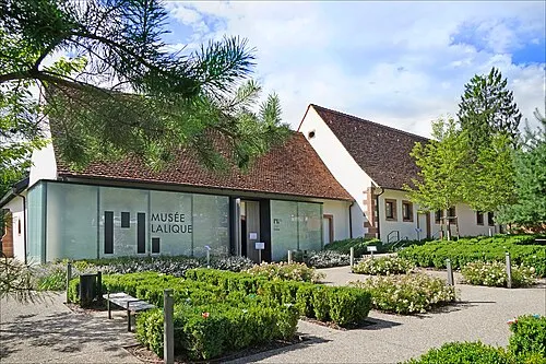 Musée Lalique Museum, Grand Est9.1 km N
-
Forêt Domaniale de la Petite-Pierre Sud Natural site, Bas-Rhin7.7 km SW
-
Chapelle Saint-Michel Attraction, Grand Est7.7 km S
-
Forêt Domaniale d'Ingwiller Natural site, Bas-Rhin10 km NE
-
Zintzel du Sud River, Bas-Rhin9.8 km SE
-
Forêt Domaniale de la Petite-Pierre Nord Natural site, Bas-Rhin11 km NW
Sources & licences
Data last updated: