Manspach
Located in Arrondissement of Altkirch, Haut-Rhin Coordinates: 47°36′59″ N 7°06′19″ E
- Population
- 573
- 573
- Elevation
- 321 m
- above sea level
- Local time
- UTC+01:00
- Europe/Paris · UTC+01:00
- Places inside
- 2
- listed under Manspach
- Airports
- BSL EuroAirport Basel–Mulhouse–Freiburg31 km
- BRN Bern Airport84 km
About Manspach
Manspach is a village. Location: Arrondissement of Altkirch, Haut-Rhin. Population: 573. Elevation: 321 m. The best months to visit are June–September. The nearest airport is EuroAirport Basel–Mulhouse–Freiburg (31 km). Nearby sights include Chapelle Saint-Martin and Barrenwackgraben.
Climate of Manspach
Best months for sightseeingBest months for sightseeing: June–September.
This month · November
A cold month
Day 8° · Night 2° · Rain 80 mm
- Hottest month
- July (day 24°)
- Coldest month
- January (night -2°)
- Wettest month
- May (86 mm)
- Driest month
- March (59 mm)
Bars: average monthly low and high temperature. Below: precipitation. Monthly averages for 1970–2000 at about 18 km resolution, adjusted for elevation. Highlighted months are mild and relatively dry. Source: WorldClim 2.1 (CC BY 4.0).
Show values as a table
| Month | Jan | Feb | Mar | Apr | May | Jun | Jul | Aug | Sep | Oct | Nov | Dec |
|---|---|---|---|---|---|---|---|---|---|---|---|---|
| Average high (°C) | 4° | 6° | 10° | 14° | 18° | 22° | 24° | 24° | 20° | 15° | 8° | 5° |
| Average low (°C) | -2° | -1° | 2° | 4° | 8° | 11° | 13° | 13° | 10° | 6° | 2° | 0° |
| Precipitation (mm) | 70 | 68 | 59 | 64 | 86 | 84 | 76 | 71 | 75 | 75 | 80 | 83 |
Other places to visit in this season: June July August September
How to get to Manspach
The nearest airport is EuroAirport Basel–Mulhouse–Freiburg (BSL), 31 km to the east as the crow flies. The nearest large city is Mulhouse, 23 km to the northeast.
Airports
- EuroAirport Basel–Mulhouse–Freiburg (BSL) Bâle / Mulhouse 31 kmeast
- Bern Airport (BRN) Bern 84 kmsouth
- Strasbourg Airport (SXB) Strasbourg 110 kmnorth
Nearby large cities
- Mulhouse Population: 111.4K 23 kmnortheast
- Basel Population: 177.6K 36 kmeast
- Freiburg im Breisgau Population: 237.5K 70 kmnortheast
- Bern Population: 121.6K 79 kmsouth
- Besançon Population: 128.4K 92 kmsouthwest
Straight-line distances; road distances are longer. Airport data: OurAirports.
Day trips from Manspach
Within 100 km: 401 historic and cultural sites, 1,212 natural sites, 354 lakes, rivers and coasts.
0–25 km112 places
- Etangs Rougeat Lake 18 kmS
- Pisciculture Lake 16 kmS
- Etang du Milieu Lake 17 kmS
- Etangs Rougeat Lake 18 kmS
25–60 km654 places
- Lake Biel Lake 60 kmS
- Häftli Lake 55 kmS
- Etang de la Gruère Lake 42 kmS
- Basler Weiher Lake 47 kmSE
60–100 km1,201 places
- Kleiner Bremgartenwald Mountain 76 kmS
- Arbeiterstrandbad Tennwil Beach 91 kmE
- Sankt Petersinsel Island 61 kmS
- Mauesee-Insel Island 88 kmSE
Straight-line distances.
Places in Manspach
2 placesBar: population relative to the most populous place in this list.
Cities & villages1
- Saint-Léger · Village
Nearby attractions & nature
Everything nearby-
Chapelle Saint-Martin Attraction, Ballersdorf3.2 km E
-
Barrenwackgraben River, Haut-Rhin3.5 km NE
-
Suarcine River, Bourgogne-Franche-Comté5.3 km W
-
Roesbaechlein River, Haut-Rhin5.8 km NE
-
Bois de Hirtzbach Natural site, Haut-Rhin8.5 km SE
-
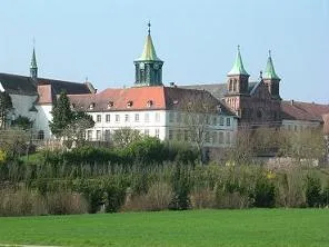 Abbaye Notre-Dame d'Oelenberg Attraction, Reiningue17 km NE
Sources & licences
Data last updated: