Arrondissement of Rochefort
Located in Charente-Maritime, New Aquitaine Coordinates: 45°55′37″ N 0°59′57″ W
- Population
- 196,439
- 196.4K
- Elevation
- 1 m
- above sea level
- Local time
- UTC+01:00
- Europe/Paris · UTC+01:00
- Places inside
- 78
- listed under Arrondissement of Rochefort
- Airports
- LRH La Rochelle Île de Ré Airport32 km
- BOD Bordeaux–Mérignac Airport124 km
About Arrondissement of Rochefort
Arrondissement of Rochefort is a municipality. Location: Charente-Maritime, New Aquitaine. Population: 196,439. Elevation: 1 m. The best months to visit are June–September. The nearest airport is La Rochelle Île de Ré Airport (32 km). Nearby sights include Fort de Piédemont and Charente.
Photos of Arrondissement of Rochefort
-
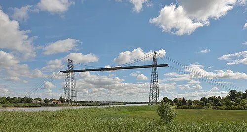
Rochefort-Martrou Transporter Bridge This Photo was taken by Wolfgang Moroder . Feel free to use my photos, but please mention me as the author and send me a · CC BY-SA 3.0

Climate of Arrondissement of Rochefort
Best months for sightseeingBest months for sightseeing: June–September.
This month · November
Outside the best season
Day 13° · Night 6° · Rain 96 mm
- Hottest month
- August (day 25°)
- Coldest month
- January (night 3°)
- Wettest month
- November (96 mm)
- Driest month
- July (37 mm)
Bars: average monthly low and high temperature. Below: precipitation. Monthly averages for 1970–2000 at about 18 km resolution, adjusted for elevation. Highlighted months are mild and relatively dry. Source: WorldClim 2.1 (CC BY 4.0).
Show values as a table
| Month | Jan | Feb | Mar | Apr | May | Jun | Jul | Aug | Sep | Oct | Nov | Dec |
|---|---|---|---|---|---|---|---|---|---|---|---|---|
| Average high (°C) | 9° | 11° | 14° | 16° | 20° | 23° | 25° | 25° | 23° | 18° | 13° | 10° |
| Average low (°C) | 3° | 4° | 5° | 7° | 10° | 13° | 15° | 15° | 13° | 10° | 6° | 4° |
| Precipitation (mm) | 83 | 72 | 57 | 63 | 61 | 42 | 37 | 44 | 69 | 87 | 96 | 88 |
Other places to visit in this season: June July August September
How to get to Arrondissement of Rochefort
The nearest airport is La Rochelle Île de Ré Airport (LRH), 32 km to the northwest as the crow flies. For international flights: Bordeaux–Mérignac Airport (BOD) (124 km). The nearest large city is Bordeaux, 125 km to the south.
Airports
- La Rochelle Île de Ré Airport (LRH) La Rochelle 32 kmnorthwest
- Bordeaux–Mérignac Airport (BOD) Bordeaux 124 kmsouth
- Poitiers-Biard Airport (PIS) Poitiers/Biard 125 kmnortheast
Nearby large cities
- Bordeaux Population: 265.3K 125 kmsouth
- Nantes Population: 325.1K 150 kmnorth
- Limoges Population: 141.2K 175 kmeast
- Angers Population: 168.3K 175 kmnorth
- Tours Population: 141.6K 209 kmnortheast
Straight-line distances; road distances are longer. Airport data: OurAirports.
Day trips from Arrondissement of Rochefort
Within 100 km: 117 historic and cultural sites, 71 natural sites, 125 lakes, rivers and coasts.
0–25 km32 places
- Oléron Island 23 kmW
- La Plage d'Aytré Beach 24 kmNW
- Île Madame Island 10 kmW
- Île d'Aix Island 17 kmNW
25–60 km118 places
- Île de Ré Island 44 kmNW
- Plage des Nonnes Beach 41 kmS
- Né River 57 kmSE
- Barzan-Plage Beach 45 kmS
60–100 km163 places
- Plage du Rocher Beach 66 kmNW
- Plage du Veillon Beach 76 kmNW
- Plage de Sauveterre Beach 94 kmNW
- Étang de Cousseau Lake 99 kmS
Straight-line distances.
Arrondissement of Rochefort and similar cities
Side by side with cities of similar size in the same country: population, elevation and climate.
| Measure | Arrondissement of Rochefort | Reims | Le Havre | Paris 20 Ménilmontant |
|---|---|---|---|---|
| Population | 196.4K | 196.6K | 186K | 185.1K |
| Elevation | 1 m | 88 m | 5 m | 96 m |
| Summer day (hottest month) | 25° | 25° | 21° | 25° |
| Winter night (coldest month) | 3° | 0° | 4° | 2° |
| Annual rainfall | 799 mm | 627 mm | 731 mm | 641 mm |
| Best months | Jun–Sep | May–Sep | Jun–Sep | May–Sep |
| Distance | — | 530 km | 405 km | 415 km |
Climate values are 1970–2000 monthly averages; straight-line distance.
Places in Arrondissement of Rochefort
78 places- 1 Rochefort 24K
- 2 Royan 18.4K
- 3 Tonnay-Charente 8K
- 4 Surgères 6.8K
- 5 Saint-Pierre-d'Oléron 6.8K
- 6 Marennes-Hiers-Brouage 6.3K
- 7 Saint-Georges-de-Didonne 5.4K
- 8 La Tremblade 4.5K
- 9 Le Château-d'Oléron 4.2K
- 10 Fouras 4K
- 11 Aigrefeuille-d'Aunis 4K
- 12 Saint-Palais-sur-Mer 3.9K
- 13 Vaux-sur-Mer 3.8K
- 14 Saint-Georges-d'Oléron 3.7K
- 15 Échillais 3.5K
- 16 Bourcefranc-le-Chapus 3.4K
- 17 Arvert 3.4K
- 18 Dolus-d'Oléron 3.3K
- 19 Saint-Sulpice-de-Royan 3.2K
- 20 Meschers-sur-Gironde 3.1K
- 21 Soubise 3K
- 22 Breuillet 2.8K
- 23 Saint-Agnant 2.7K
- 24 Étaules 2.4K
- 25 Le Gua 2.1K
- 26 Saint-Laurent-de-la-Prée 2.1K
- 27 Saint-Just-Luzac 2K
- 28 Les Mathes 2K
- 29 Le Thou 1.9K
- 30 Port-des-Barques 1.8K
- 31 Saint-Georges-du-Bois 1.8K
- 32 Breuil-Magné 1.7K
- 33 Saint-Pierre-La-Noue 1.6K
- 34 Chaillevette 1.5K
- 35 Saint-Hippolyte 1.4K
- 36 Saint-Denis-d'Oléron 1.3K
- 37 Saint-Augustin 1.3K
- 38 Ciré-d'Aunis 1.3K
- 39 Muron 1.3K
- 40 Cabariot 1.3K
- 41 Saint-Trojan-les-Bains 1.3K
- 42 Forges 1.3K
- 43 Nieulle-sur-Seudre 1.2K
- 44 Saint-Mard 1.2K
- 45 Vergeroux 1.2K
- 46 Saint-Nazaire-sur-Charente 1.2K
- 47 La Devise 1.1K
- 48 Le Grand-Village-Plage 1K
- 49 Lussant 996
- 50 Marsais 914
- 51 Chambon 911
- 52 Bouhet 894
- 53 L'Éguille 876
- 54 Saint-Saturnin-du-Bois 873
- 55 Genouillé 869
- 56 Ardillières 846
- 57 Mornac-sur-Seudre 834
- 58 Ballon 793
- 59 Beaugeay 769
- 60 Virson 758
Bar: population relative to the most populous place in this list.
Nearby attractions & nature
Everything nearby-
Fort de Piédemont Historic site, New Aquitaine7 km W
-
Charente River, New Aquitaine6.6 km NW
-
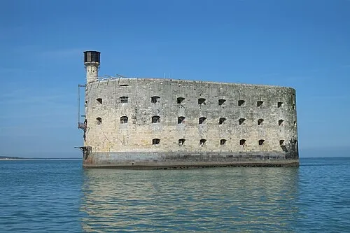 Fort Boyard Historic site, New Aquitaine19 km NW
-
Île Madame Island, New Aquitaine9.5 km W
-
Fort d'Énette Historic site, New Aquitaine12 km NW
-
Dunes de Saint-Trojan Natural site, Charente-Maritime19 km SW
-
Anse de Fouras Natural site, New Aquitaine10 km NW
-
Forêt Domaniale de Saint-Trojan Natural site, Charente-Maritime21 km SW
Sources & licences
Data last updated: