Boutonne River
Located in Charente-Maritime, New Aquitaine Coordinates: 45°54′33″ N 0°49′33″ W
- Elevation
- 2 m
- above sea level
- Local time
- UTC+01:00
- Europe/Paris · UTC+01:00
- Airports
- LRH La Rochelle Île de Ré Airport41 km
- PIS Poitiers-Biard Airport115 km
About Boutonne River
Boutonne River is a river. Location: Charente-Maritime, New Aquitaine. The best months to visit are June–September. The nearest airport is La Rochelle Île de Ré Airport (41 km). Nearby sights include Rochefort-Martrou Transporter Bridge and Île Madame.
Climate of Boutonne River
Best months for sightseeingBest months for sightseeing: June–September.
This month · November
Outside the best season
Day 13° · Night 5° · Rain 98 mm
- Hottest month
- August (day 25°)
- Coldest month
- January (night 3°)
- Wettest month
- November (98 mm)
- Driest month
- July (39 mm)
Bars: average monthly low and high temperature. Below: precipitation. Monthly averages for 1970–2000 at about 18 km resolution, adjusted for elevation. Highlighted months are mild and relatively dry. Source: WorldClim 2.1 (CC BY 4.0).
Show values as a table
| Month | Jan | Feb | Mar | Apr | May | Jun | Jul | Aug | Sep | Oct | Nov | Dec |
|---|---|---|---|---|---|---|---|---|---|---|---|---|
| Average high (°C) | 9° | 11° | 14° | 16° | 20° | 23° | 25° | 25° | 23° | 18° | 13° | 10° |
| Average low (°C) | 3° | 3° | 5° | 6° | 10° | 13° | 15° | 15° | 12° | 9° | 5° | 4° |
| Precipitation (mm) | 84 | 71 | 58 | 65 | 63 | 44 | 39 | 48 | 69 | 86 | 98 | 88 |
Other places to visit in this season: June July August September
How to get to Boutonne River
The nearest airport is La Rochelle Île de Ré Airport (LRH), 41 km to the northwest as the crow flies. For international flights: Bordeaux–Mérignac Airport (BOD) (120 km). The nearest large city is Bordeaux, 120 km to the south.
Airports
- La Rochelle Île de Ré Airport (LRH) La Rochelle 41 kmnorthwest
- Poitiers-Biard Airport (PIS) Poitiers/Biard 115 kmnortheast
- Bordeaux–Mérignac Airport (BOD) Bordeaux 120 kmsouth
Nearby large cities
- Bordeaux Population: 265.3K 120 kmsouth
- Nantes Population: 325.1K 156 kmnorth
- Limoges Population: 141.2K 161 kmeast
- Angers Population: 168.3K 175 kmnorth
- Tours Population: 141.6K 202 kmnortheast
Straight-line distances; road distances are longer. Airport data: OurAirports.
Nearest towns and villages
-
La Vallée Village, La Vallée2.3 km SW
-
La Vallée Village, Arrondissement of Saintes2.3 km SW
-
Cabariot Village, Arrondissement of Rochefort3 km NW
-
Champdolent Village, Champdolent2.2 km NE
-
Cabariot Village, Cabariot3 km NW
-
Champdolent Village, Arrondissement of Saint-Jean-d'Angély2.2 km NE
Nearby attractions & nature
Everything nearby-
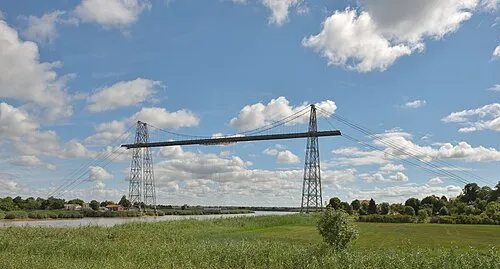 Rochefort-Martrou Transporter Bridge Landmark, Rochefort10 km W
-
Île Madame Island, New Aquitaine23 km W
-
Charente River, New Aquitaine20 km W
-
Ruisseau la Soie River, Charente-Maritime16 km NE
-
Trézence River, Charente-Maritime17 km NE
-
Devise River, Charente-Maritime17 km N
-
Anse de Fouras Natural site, New Aquitaine22 km NW
-
Baie d'Yves Natural site, Yves23 km NW
Sources & licences
Data last updated: