Ruisseau de Planche
Located in Corrèze department, New Aquitaine Coordinates: 45°08′23″ N 1°29′33″ E
- Elevation
- 137 m
- above sea level
- Local time
- UTC+01:00
- Europe/Paris · UTC+01:00
- Airports
- BVE Brive Souillac airport11 km
- AUR Aurillac airport78 km
About Ruisseau de Planche
Ruisseau de Planche is a river. Location: Corrèze department, New Aquitaine. The best months to visit are May–September. The nearest airport is Brive Souillac airport (11 km). Nearby sights include Maumont and Corrèze.
Photos of Ruisseau de Planche
-
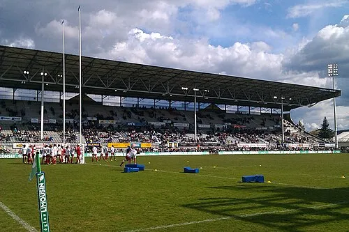
Stade Amedee Domenech Daxipedia · CC BY-SA 3.0

Climate of Ruisseau de Planche
Best months for sightseeingBest months for sightseeing: May–September.
This month · November
Outside the best season
Day 13° · Night 5° · Rain 81 mm
- Hottest month
- July (day 27°)
- Coldest month
- January (night 2°)
- Wettest month
- May (89 mm)
- Driest month
- July (56 mm)
Bars: average monthly low and high temperature. Below: precipitation. Monthly averages for 1970–2000 at about 18 km resolution, adjusted for elevation. Highlighted months are mild and relatively dry. Source: WorldClim 2.1 (CC BY 4.0).
Show values as a table
| Month | Jan | Feb | Mar | Apr | May | Jun | Jul | Aug | Sep | Oct | Nov | Dec |
|---|---|---|---|---|---|---|---|---|---|---|---|---|
| Average high (°C) | 9° | 11° | 14° | 16° | 21° | 24° | 27° | 27° | 23° | 18° | 13° | 10° |
| Average low (°C) | 2° | 3° | 4° | 6° | 10° | 13° | 15° | 15° | 12° | 9° | 5° | 3° |
| Precipitation (mm) | 76 | 74 | 64 | 79 | 89 | 75 | 56 | 64 | 78 | 87 | 81 | 80 |
Other places to visit in this season: May June July August September
How to get to Ruisseau de Planche
The nearest airport is Brive Souillac airport (BVE), 11 km to the south as the crow flies. The nearest large city is Limoges, 79 km to the north.
Airports
- Brive Souillac airport (BVE) Brive 11 kmsouth
- Aurillac airport (AUR) Aurillac 78 kmeast
- Limoges Airport (LIG) Limoges/Bellegarde 84 kmnorth
Nearby large cities
- Limoges Population: 141.2K 79 kmnorth
- Clermont-Ferrand Population: 147.9K 144 kmnortheast
- Bordeaux Population: 265.3K 167 kmwest
- Toulouse Population: 511.7K 171 kmsouth
- Saint-Etienne Population: 176.3K 230 kmeast
Straight-line distances; road distances are longer. Airport data: OurAirports.
Day trips from Ruisseau de Planche
Within 100 km: 133 historic and cultural sites, 112 natural sites, 162 lakes, rivers and coasts.
0–25 km20 places
- Roche de Vic Mountain 23 kmE
- Roc de Maille Mountain 23 kmE
- Puy d'Yssandon Mountain 12 kmNW
- Bois de Blanchefort Natural site 25 kmN
25–60 km98 places
- Étang de Taysse Lake 36 kmNE
- Étang de Ruffaud Lake 35 kmNE
- Étang du Prévôt Lake 42 kmNE
- Étang de Pissevache Lake 31 kmNE
60–100 km289 places
- Vassivière Island 79 kmN
- Ancien îlot Gambetta Island 79 kmE
- Lac de Madic Lake 80 kmE
- Grand Étang de la Gourgousse Lake 70 kmNW
Straight-line distances.
Nearest towns and villages
-
Brive-la-Gaillarde Village, Arrondissement of Brive-la-Gaillarde3.8 km NE
-
Brive-la-Gaillarde Town, Brive-la-Gaillarde3.9 km NE
-
Saint-Pantaléon-de-Larche Village, Arrondissement of Brive-la-Gaillarde3.6 km W
-
Lacombe Village, Brive-la-Gaillarde0.6 km SW
-
Saint-Pantaléon-de-Larche Village, Saint-Pantaléon-de-Larche3.6 km W
-
Bouquet Bas Village, Brive-la-Gaillarde0.7 km N
Nearby attractions & nature
Everything nearby-
Maumont River, Corrèze department3.5 km NW
-
Corrèze River, Corrèze department3.9 km NW
-
Stade Amedee Domenech Landmark, Brive-la-Gaillarde5.1 km NE
-
Loyre River, Corrèze department6.4 km NW
-
Couze River, Corrèze department6.5 km W
-
Puy d'Yssandon Mountain, Yssandon12 km NW
-
Château de la Fage Historic site, Noailles6.6 km S
-
Bois de Blanchefort Natural site, Corrèze department25 km N
Sources & licences
Data last updated: