Arrondissement of Sarlat-la-Canéda
Located in Dordogne, New Aquitaine Coordinates: 44°58′00″ N 1°08′00″ E
- Population
- 81,563
- 81.6K
- Elevation
- 194 m
- above sea level
- Local time
- UTC+01:00
- Europe/Paris · UTC+01:00
- Places inside
- 136
- listed under Arrondissement of Sarlat-la-Canéda
- Airports
- BVE Brive Souillac airport29 km
- EGC Bergerac Dordogne-Périgord airport51 km
About Arrondissement of Sarlat-la-Canéda
Arrondissement of Sarlat-la-Canéda is a municipality. Location: Dordogne, New Aquitaine. Population: 81,563. Elevation: 194 m. The best months to visit are June–September. The nearest airport is Brive Souillac airport (29 km). Nearby sights include Beune and Vallée de la Dordogne.
Photos of Arrondissement of Sarlat-la-Canéda
-
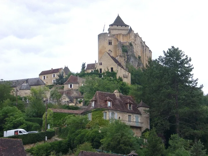
Château de Castelnaud-la-Chapelle Wikimedia Commons · CC BY-SA 3.0

Climate of Arrondissement of Sarlat-la-Canéda
Best months for sightseeingBest months for sightseeing: June–September.
This month · November
Outside the best season
Day 12° · Night 5° · Rain 89 mm
- Hottest month
- July (day 26°)
- Coldest month
- January (night 2°)
- Wettest month
- November (89 mm)
- Driest month
- July (56 mm)
Bars: average monthly low and high temperature. Below: precipitation. Monthly averages for 1970–2000 at about 18 km resolution, adjusted for elevation. Highlighted months are mild and relatively dry. Source: WorldClim 2.1 (CC BY 4.0).
Show values as a table
| Month | Jan | Feb | Mar | Apr | May | Jun | Jul | Aug | Sep | Oct | Nov | Dec |
|---|---|---|---|---|---|---|---|---|---|---|---|---|
| Average high (°C) | 9° | 10° | 14° | 16° | 20° | 23° | 26° | 26° | 23° | 18° | 12° | 10° |
| Average low (°C) | 2° | 2° | 4° | 6° | 10° | 12° | 14° | 14° | 12° | 9° | 5° | 3° |
| Precipitation (mm) | 82 | 80 | 67 | 80 | 87 | 71 | 56 | 61 | 79 | 88 | 89 | 89 |
Other places to visit in this season: June July August September
How to get to Arrondissement of Sarlat-la-Canéda
The nearest airport is Brive Souillac airport (BVE), 29 km to the east as the crow flies. The nearest large city is Limoges, 97 km to the north.
Airports
- Brive Souillac airport (BVE) Brive 29 kmeast
- Bergerac Dordogne-Périgord airport (EGC) Bergerac 51 kmwest
- Limoges Airport (LIG) Limoges/Bellegarde 100 kmnorth
Nearby large cities
- Limoges Population: 141.2K 97 kmnorth
- Bordeaux Population: 265.3K 136 kmwest
- Toulouse Population: 511.7K 153 kmsouth
- Clermont-Ferrand Population: 147.9K 178 kmnortheast
- Saint-Etienne Population: 176.3K 261 kmeast
Straight-line distances; road distances are longer. Airport data: OurAirports.
Day trips from Arrondissement of Sarlat-la-Canéda
Within 100 km: 75 historic and cultural sites, 62 natural sites, 187 lakes, rivers and coasts.
0–25 km19 places
- Forêt Barade Natural site 19 kmNW
- Les jardins de Marqueyssac Natural site 16 kmS
- Vallée de la Dordogne Natural site 14 kmS
- Russeau de Vitrac River 17 kmSE
25–60 km80 places
- Pech de Dreuilles Mountain 34 kmSE
- Roche de Vic Mountain 54 kmE
- Roc de Maille Mountain 53 kmE
- Puy d'Yssandon Mountain 33 kmNE
60–100 km225 places
- Étang de Taysse Lake 70 kmNE
- Étang de Ruffaud Lake 69 kmNE
- Étang du Prévôt Lake 75 kmNE
- Étang de Pissevache Lake 64 kmNE
Straight-line distances.
Arrondissement of Sarlat-la-Canéda and similar cities
Side by side with cities of similar size in the same country: population, elevation and climate.
| Measure | Arrondissement of Sarlat-la-Canéda | Pau | Créteil | Versailles |
|---|---|---|---|---|
| Population | 81.6K | 82.7K | 84.8K | 85.4K |
| Elevation | 194 m | 219 m | 49 m | 140 m |
| Summer day (hottest month) | 26° | 25° | 25° | 24° |
| Winter night (coldest month) | 2° | 4° | 2° | 1° |
| Annual rainfall | 929 mm | 1,304 mm | 632 mm | 646 mm |
| Best months | Jun–Sep | Jun–Sep | May–Sep | Jun–Sep |
| Distance | — | 219 km | 437 km | 433 km |
Climate values are 1970–2000 monthly averages; straight-line distance.
Places in Arrondissement of Sarlat-la-Canéda
136 places- 1 Sarlat-la-Canéda 8.9K
- 2 Terrasson-Lavilledieu 6.1K
- 3 Montignac-Lascaux 2.8K
- 4 Le Bugue 2.7K
- 5 Le Lardin-Saint-Lazare 1.8K
- 6 Carsac-Aillac 1.6K
- 7 Rouffignac-Saint-Cernin-de-Reilhac 1.6K
- 8 Saint-Cyprien 1.6K
- 9 Pays de Belvès 1.5K
- 10 Thenon 1.3K
- 11 Coux et Bigaroque-Mouzens 1.2K
- 12 Cénac-et-Saint-Julien 1.2K
- 13 Salignac-Eyvigues 1.2K
- 14 Les Eyzies 1.1K
- 15 Siorac-en-Périgord 1K
- 16 Proissans 1K
- 17 Saint-Geniès 947
- 18 Hautefort 946
- 19 Domme 912
- 20 La Bachellerie 901
- 21 Condat-sur-Vézère 893
- 22 Pazayac 869
- 23 Saint-André-d'Allas 822
- 24 Castels et Bézenac 804
- 25 Vitrac 803
- 26 Marcillac-Saint-Quentin 781
- 27 La Feuillade 735
- 28 Plazac 717
- 29 Beauregard-de-Terrasson 716
- 30 Villefranche-du-Périgord 704
- 31 Carlux 655
- 32 Groléjac 649
- 33 Meyrals 638
- 34 Tourtoirac 636
- 35 Aubas 621
- 36 Vézac 620
- 37 Saint-Julien-de-Lampon 618
- 38 Coly-Saint-Amand 605
- 39 Saint-Martial-de-Nabirat 595
- 40 Saint-Rabier 589
- 41 Les Coteaux Périgourdins 587
- 42 Sainte-Nathalène 578
- 43 Peyrignac 577
- 44 Marquay 575
- 45 Fossemagne 556
- 46 Prats-de-Carlux 556
- 47 Beynac-et-Cazenac 550
- 48 Daglan 549
- 49 La Chapelle-Aubareil 535
- 50 Saint-Chamassy 525
- 51 Saint-Crépin-et-Carlucet 518
- 52 Calviac-en-Périgord 502
- 53 Journiac 496
- 54 Castelnaud-la-Chapelle 464
- 55 Azerat 463
- 56 La Roque-Gageac 453
- 57 Limeyrat 447
- 58 Saint-Léon-sur-Vézère 429
- 59 Badefols-d'Ans 415
- 60 La Dornac 405
Bar: population relative to the most populous place in this list.
Nearby attractions & nature
Everything nearby-
Beune River, Dordogne10 km W
-
Vallée de la Dordogne Natural site, Dordogne14 km S
-
Céou River, Dordogne17 km S
-
Russeau de Vitrac River, Dordogne17 km SE
-
Ruisseau Chironde River, Dordogne16 km NE
-
Les Milandes Historic site, Occitanie16 km S
-
Forêt Barade Natural site, Dordogne19 km NW
-
Ruisseau le Coly River, Dordogne18 km NE
Sources & licences
Data last updated: