Arrondissement of Bergerac
Located in Dordogne, New Aquitaine Coordinates: 44°49′14″ N 0°29′20″ E
- Population
- 103,299
- 103.3K
- Elevation
- 46 m
- above sea level
- Local time
- UTC+01:00
- Europe/Paris · UTC+01:00
- Places inside
- 130
- listed under Arrondissement of Bergerac
- Airports
- EGC Bergerac Dordogne-Périgord airport2 km
- BVE Brive Souillac airport82 km
About Arrondissement of Bergerac
Arrondissement of Bergerac is a municipality. Location: Dordogne, New Aquitaine. Population: 103,299. Elevation: 46 m. The best months to visit are May–September. The nearest airport is Bergerac Dordogne-Périgord airport (2 km). Nearby sights include Caudau and Couillou.
Photos of Arrondissement of Bergerac
-
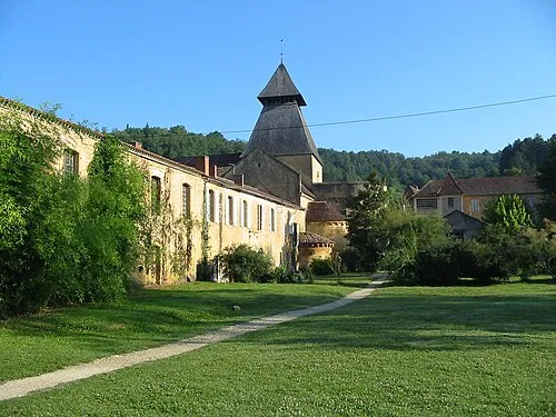
Cadouin Abbey Benjamin Lefèvre · CC BY-SA 3.0

Climate of Arrondissement of Bergerac
Best months for sightseeingBest months for sightseeing: May–September.
This month · November
A wet month
Day 13° · Night 5° · Rain 105 mm
- Hottest month
- August (day 27°)
- Coldest month
- January (night 3°)
- Wettest month
- November (105 mm)
- Driest month
- July (54 mm)
Bars: average monthly low and high temperature. Below: precipitation. Monthly averages for 1970–2000 at about 18 km resolution, adjusted for elevation. Highlighted months are mild and relatively dry. Source: WorldClim 2.1 (CC BY 4.0).
Show values as a table
| Month | Jan | Feb | Mar | Apr | May | Jun | Jul | Aug | Sep | Oct | Nov | Dec |
|---|---|---|---|---|---|---|---|---|---|---|---|---|
| Average high (°C) | 10° | 12° | 15° | 17° | 21° | 24° | 27° | 27° | 24° | 19° | 13° | 11° |
| Average low (°C) | 3° | 3° | 4° | 6° | 10° | 13° | 15° | 15° | 12° | 9° | 5° | 3° |
| Precipitation (mm) | 92 | 85 | 70 | 78 | 84 | 65 | 54 | 61 | 84 | 90 | 105 | 104 |
Other places to visit in this season: May June July August September
How to get to Arrondissement of Bergerac
The nearest airport is Bergerac Dordogne-Périgord airport (EGC), 2 km to the east as the crow flies. For international flights: Bordeaux–Mérignac Airport (BOD) (95 km). The nearest large city is Bordeaux, 85 km to the west.
Airports
- Bergerac Dordogne-Périgord airport (EGC) Bergerac 2 kmeast
- Brive Souillac airport (BVE) Brive 82 kmeast
- Bordeaux–Mérignac Airport (BOD) Bordeaux 95 kmwest
Nearby large cities
- Bordeaux Population: 265.3K 85 kmwest
- Limoges Population: 141.2K 127 kmnortheast
- Toulouse Population: 511.7K 155 kmsoutheast
- Clermont-Ferrand Population: 147.9K 230 kmnortheast
- Donostia / San Sebastian Population: 185.4K 259 kmsouthwest
Straight-line distances; road distances are longer. Airport data: OurAirports.
Day trips from Arrondissement of Bergerac
Within 100 km: 81 historic and cultural sites, 38 natural sites, 238 lakes, rivers and coasts.
0–25 km16 places
- Forêt de Monclard Natural site 15 kmNE
- Forêt de Liorac Natural site 14 kmNE
- Lescouroux River 21 kmSW
- Ruisseau du Seignal River 20 kmW
25–60 km110 places
- Bois de Verteuil Natural site 37 kmS
- Forêt du Mas d'Agenais et de Senestis Natural site 54 kmSW
- Forêt de Lammary Natural site 54 kmNE
- Bois de Fonteillac Natural site 57 kmN
60–100 km231 places
- Île d'Ambès Island 86 kmW
- Île Margaux Island 93 kmW
- Grand Étang de la Gourgousse Lake 86 kmN
- Pech de Dreuilles Mountain 76 kmE
Straight-line distances.
Arrondissement of Bergerac and similar cities
Side by side with cities of similar size in the same country: population, elevation and climate.
| Measure | Arrondissement of Bergerac | Nancy | Argenteuil | Boulogne-Billancourt |
|---|---|---|---|---|
| Population | 103.3K | 105.1K | 101.5K | 108.8K |
| Elevation | 46 m | 212 m | 37 m | 35 m |
| Summer day (hottest month) | 27° | 24° | 25° | 25° |
| Winter night (coldest month) | 3° | -1° | 2° | 2° |
| Annual rainfall | 972 mm | 789 mm | 632 mm | 632 mm |
| Best months | May–Sep | Jun–Sep | May–Sep | May–Sep |
| Distance | — | 611 km | 478 km | 466 km |
Climate values are 1970–2000 monthly averages; straight-line distance.
Places in Arrondissement of Bergerac
130 places- 1 Bergerac 27.3K
- 2 Prigonrieux 4.4K
- 3 Lalinde 2.9K
- 4 Lamonzie-Saint-Martin 2.7K
- 5 La Force 2.6K
- 6 Eymet 2.6K
- 7 Port-Sainte-Foy-et-Ponchapt 2.5K
- 8 Le Buisson-de-Cadouin 2K
- 9 Saint-Antoine-de-Breuilh 1.9K
- 10 Beaumontois en Périgord 1.8K
- 11 Saint-Pierre-d'Eyraud 1.8K
- 12 Creysse 1.7K
- 13 Gardonne 1.6K
- 14 Cours-de-Pile 1.6K
- 15 Le Fleix 1.5K
- 16 Lamothe-Montravel 1.4K
- 17 Montcaret 1.4K
- 18 Lembras 1.3K
- 19 Sigoulès-et-Flaugeac 1.2K
- 20 Mouleydier 1.2K
- 21 Vélines 1.1K
- 22 Saint-Laurent-des-Vignes 1K
- 23 Villefranche-de-Lonchat 973
- 24 Saint-Nexans 958
- 25 Saint-Germain-et-Mons 908
- 26 Mauzac-et-Grand-Castang 875
- 27 Saint-Sauveur 844
- 28 Monbazillac 829
- 29 Saint-Méard-de-Gurçon 806
- 30 Ginestet 762
- 31 Issigeac 744
- 32 Pomport 735
- 33 Couze-et-Saint-Front 709
- 34 Lamonzie-Montastruc 708
- 35 Faux 672
- 36 Saint-Martin-de-Gurson 653
- 37 Trémolat 624
- 38 Bouniagues 583
- 39 Saint-Capraise-de-Lalinde 536
- 40 Queyssac 533
- 41 Saint-Rémy 508
- 42 Lanquais 506
- 43 Fougueyrolles 495
- 44 Minzac 495
- 45 Saint-Seurin-de-Prats 461
- 46 Lunas 459
- 47 Capdrot 458
- 48 Varennes 458
- 49 Pressignac-Vicq 456
- 50 Gageac-et-Rouillac 448
- 51 Thénac 443
- 52 Monpazier 441
- 53 Montpeyroux 441
- 54 Saint-Agne 438
- 55 Saussignac 429
- 56 Saint-Avit-Sénieur 422
- 57 Plaisance 412
- 58 Monestier 384
- 59 Alles-sur-Dordogne 380
- 60 Molières 370
Bar: population relative to the most populous place in this list.
Nearby attractions & nature
Everything nearby-
Caudau River, Dordogne4.1 km NW
-
Couillou River, Dordogne8.8 km NE
-
Gardonnette River, Dordogne11 km W
-
Ruisseau l'Eyraud River, Dordogne11 km W
-
Louyre River, Dordogne12 km NE
-
Besage River, Dordogne11 km W
-
Forêt de Liorac Natural site, Dordogne14 km NE
-
Forêt de Monclard Natural site, Dordogne15 km NE
Sources & licences
Data last updated: