Arrondissement of Langon
Located in Gironde, New Aquitaine Coordinates: 44°31′45″ N 0°15′11″ W
- Population
- 134,929
- 134.9K
- Elevation
- 35 m
- above sea level
- Local time
- UTC+01:00
- Europe/Paris · UTC+01:00
- Places inside
- 195
- listed under Arrondissement of Langon
- Airports
- BOD Bordeaux–Mérignac Airport50 km
- EGC Bergerac Dordogne-Périgord airport69 km
About Arrondissement of Langon
Arrondissement of Langon is a municipality. Location: Gironde, New Aquitaine. Population: 134,929. Elevation: 35 m. The best months to visit are May–September. The nearest airport is Bordeaux–Mérignac Airport (50 km). Nearby sights include Ruisseau de Brion and Château de Malle.
Climate of Arrondissement of Langon
Best months for sightseeingBest months for sightseeing: May–September.
This month · November
Outside the best season
Day 13° · Night 5° · Rain 97 mm
- Hottest month
- July (day 26°)
- Coldest month
- January (night 2°)
- Wettest month
- December (102 mm)
- Driest month
- July (49 mm)
Bars: average monthly low and high temperature. Below: precipitation. Monthly averages for 1970–2000 at about 18 km resolution, adjusted for elevation. Highlighted months are mild and relatively dry. Source: WorldClim 2.1 (CC BY 4.0).
Show values as a table
| Month | Jan | Feb | Mar | Apr | May | Jun | Jul | Aug | Sep | Oct | Nov | Dec |
|---|---|---|---|---|---|---|---|---|---|---|---|---|
| Average high (°C) | 10° | 12° | 15° | 17° | 21° | 24° | 26° | 26° | 23° | 19° | 13° | 10° |
| Average low (°C) | 2° | 2° | 4° | 6° | 10° | 13° | 14° | 14° | 12° | 9° | 5° | 3° |
| Precipitation (mm) | 88 | 80 | 66 | 71 | 79 | 63 | 49 | 60 | 78 | 83 | 97 | 102 |
Other places to visit in this season: May June July August September
How to get to Arrondissement of Langon
The nearest airport is Bordeaux–Mérignac Airport (BOD), 50 km to the northwest as the crow flies. The nearest large city is Bordeaux, 43 km to the northwest.
Airports
- Bordeaux–Mérignac Airport (BOD) Bordeaux 50 kmnorthwest
- Bergerac Dordogne-Périgord airport (EGC) Bergerac 69 kmnortheast
- Pau Pyrénées Airport (PUF) Pau/Pyrénées (Uzein) 128 kmsouth
Nearby large cities
- Bordeaux Population: 265.3K 43 kmnorthwest
- Toulouse Population: 511.7K 170 kmsoutheast
- Limoges Population: 141.2K 187 kmnortheast
- Donostia / San Sebastian Population: 185.4K 193 kmsouthwest
- Pamplona Population: 208.2K 221 kmsouthwest
Straight-line distances; road distances are longer. Airport data: OurAirports.
Day trips from Arrondissement of Langon
Within 100 km: 57 historic and cultural sites, 44 natural sites, 266 lakes, rivers and coasts.
0–25 km33 places
- Bois de Magrin Natural site 19 kmSW
- Château de Malle Natural site 5 kmNW
- Vignague River 16 kmNE
- Ruisseau Turssan River 9 kmW
25–60 km135 places
- Bois de Verteuil Natural site 53 kmE
- Forêt de Tresouts Natural site 36 kmS
- Forêt du Mas d'Agenais et de Senestis Natural site 39 kmSE
- Bois de Lubec Natural site 57 kmNW
60–100 km199 places
- Plage du Vivier Beach 80 kmW
- Plage des Arbousiers Beach 76 kmW
- Plage des Américains Beach 80 kmW
- Plage de l'océan Beach 81 kmW
Straight-line distances.
Arrondissement of Langon and similar cities
Side by side with cities of similar size in the same country: population, elevation and climate.
| Measure | Arrondissement of Langon | Paris 14 Observatoire | Paris 12 Reuilly | Paris 11 Popincourt |
|---|---|---|---|---|
| Population | 134.9K | 136.5K | 138K | 138.2K |
| Elevation | 35 m | 70 m | 46 m | 43 m |
| Summer day (hottest month) | 26° | 25° | 25° | 25° |
| Winter night (coldest month) | 2° | 2° | 2° | 2° |
| Annual rainfall | 916 mm | 643 mm | 641 mm | 641 mm |
| Best months | May–Sep | Jun–Sep | May–Sep | May–Sep |
| Distance | — | 517 km | 520 km | 522 km |
Climate values are 1970–2000 monthly averages; straight-line distance.
Places in Arrondissement of Langon
195 places- 1 Langon 7.4K
- 2 Bazas 4.8K
- 3 La Réole 4.4K
- 4 Podensac 3.3K
- 5 Toulenne 2.9K
- 6 Cadillac-sur-Garonne 2.8K
- 7 Portets 2.6K
- 8 Landiras 2.3K
- 9 Langoiran 2.2K
- 10 Preignac 2.1K
- 11 Cérons 2.1K
- 12 Saint-Macaire 2.1K
- 13 Targon 2.1K
- 14 Barsac 2.1K
- 15 Saint-Maixant 1.9K
- 16 Sauveterre-de-Guyenne 1.9K
- 17 Saint-Symphorien 1.8K
- 18 Roaillan 1.8K
- 19 Noaillan 1.7K
- 20 Fargues 1.7K
- 21 Monségur 1.6K
- 22 Hostens 1.6K
- 23 Rions 1.5K
- 24 Castets et Castillon 1.5K
- 25 Captieux 1.4K
- 26 Illats 1.4K
- 27 Arbanats 1.4K
- 28 Saint-Pierre-d'Aurillac 1.3K
- 29 Béguey 1.3K
- 30 Gironde-sur-Dropt 1.2K
- 31 Lamothe-Landerron 1.2K
- 32 Grignols 1.2K
- 33 Saint-Pierre-de-Mons 1.2K
- 34 Origne 1.2K
- 35 Paillet 1.2K
- 36 Caudrot 1.1K
- 37 Bernos-Beaulac 1.1K
- 38 Virelade 1.1K
- 39 Loupiac 1.1K
- 40 Villandraut 1.1K
- 41 Coimères 1.1K
- 42 Préchac 1.1K
- 43 Verdelais 1K
- 44 Auros 1K
- 45 Blasimon 959
- 46 Pellegrue 923
- 47 Léogeats 902
- 48 Saint-Michel-de-Rieufret 868
- 49 Sainte-Croix-du-Mont 838
- 50 Le Pian-sur-Garonne 837
- 51 Budos 823
- 52 Capian 809
- 53 Frontenac 803
- 54 Cudos 793
- 55 Pujols-sur-Ciron 789
- 56 Sauternes 788
- 57 Aillas 786
- 58 Mazères 778
- 59 Fontet 746
- 60 Louchats 683
Bar: population relative to the most populous place in this list.
Nearby attractions & nature
Everything nearby-
Ruisseau de Brion River, Gironde3.4 km N
-
Château de Malle Natural site, New Aquitaine5.3 km NW
-
Ruisseau le Galouchey River, Gironde6.1 km N
-
Ruisseau la Beuve River, Gironde7.3 km NE
-
Ruisseau Turssan River, Gironde8.8 km W
-
Ciron River River, Gironde8.9 km NW
-
Ruisseau de la Hure River, Gironde11 km SW
-
Ruisseau du Baillon River, Gironde12 km SW
Other cities and towns in Gironde
-
Langon Town, Langon2.6 km N
-
Bazas Town, Bazas11 km S
-
Arrondissement of Bordeaux Municipality, Gironde41 km NW
-
Arrondissement of Libourne Municipality, Gironde45 km N
-
Bègles Town, Bègles39 km NW
-
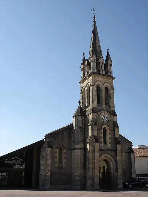 Cestas Town, Cestas42 km NW
Sources & licences
Data last updated: