Arrondissement of Bayonne
Located in Pyrénées-Atlantiques, New Aquitaine Coordinates: 43°19′23″ N 1°16′24″ W
- Population
- 313,188
- 313.2K
- Elevation
- 212 m
- above sea level
- Local time
- UTC+01:00
- Europe/Paris · UTC+01:00
- Places inside
- 123
- listed under Arrondissement of Bayonne
- Airports
- BIQ Biarritz Pays Basque airport26 km
- EAS San Sebastián Airport42 km
About Arrondissement of Bayonne
Arrondissement of Bayonne is a municipality. Location: Pyrénées-Atlantiques, New Aquitaine. Population: 313,188. Elevation: 212 m. The best months to visit are June–September. The nearest airport is Biarritz Pays Basque airport (26 km). Nearby sights include Regata de Arizacun and Ruisseau le Lacca.
Photos of Arrondissement of Bayonne
-
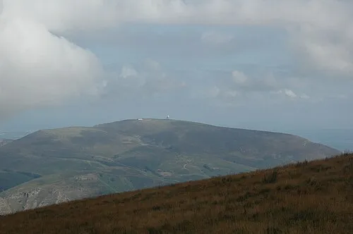
Artzamendi No machine-readable author provided. Harrieta171 assumed · CC BY 2.5 -

Stade Jean Dauger Daniel VILLAFRUELA · CC BY-SA 4.0


Climate of Arrondissement of Bayonne
Best months for sightseeingBest months for sightseeing: June–September.
This month · November
A wet month
Day 15° · Night 7° · Rain 135 mm
- Hottest month
- August (day 25°)
- Coldest month
- January (night 4°)
- Wettest month
- November (135 mm)
- Driest month
- July (61 mm)
Bars: average monthly low and high temperature. Below: precipitation. Monthly averages for 1970–2000 at about 18 km resolution, adjusted for elevation. Highlighted months are mild and relatively dry. Source: WorldClim 2.1 (CC BY 4.0).
Show values as a table
| Month | Jan | Feb | Mar | Apr | May | Jun | Jul | Aug | Sep | Oct | Nov | Dec |
|---|---|---|---|---|---|---|---|---|---|---|---|---|
| Average high (°C) | 12° | 13° | 15° | 16° | 19° | 22° | 25° | 25° | 24° | 20° | 15° | 13° |
| Average low (°C) | 4° | 5° | 5° | 7° | 10° | 13° | 15° | 15° | 13° | 11° | 7° | 5° |
| Precipitation (mm) | 121 | 101 | 92 | 119 | 97 | 69 | 61 | 82 | 79 | 117 | 135 | 117 |
Other places to visit in this season: June July August September
How to get to Arrondissement of Bayonne
The nearest airport is Biarritz Pays Basque airport (BIQ), 26 km to the northwest as the crow flies. The nearest large city is Donostia / San Sebastian, 57 km to the west.
Airports
- Biarritz Pays Basque airport (BIQ) Biarritz 26 kmnorthwest
- San Sebastián Airport (EAS) Hondarribia 42 kmwest
- Pamplona Airport (PNA) Pamplona 69 kmsouthwest
Nearby large cities
- Donostia / San Sebastian Population: 185.4K 57 kmwest
- Pamplona Population: 208.2K 64 kmsouthwest
- Vitoria-Gasteiz Population: 257.4K 125 kmsouthwest
- Bilbao Population: 347.3K 134 kmwest
- Logroño Population: 151.2K 135 kmsouthwest
Straight-line distances; road distances are longer. Airport data: OurAirports.
Day trips from Arrondissement of Bayonne
Within 100 km: 135 historic and cultural sites, 699 natural sites, 210 lakes, rivers and coasts.
0–25 km77 places
- Gorramendi Mountain 19 kmSW
- Autza Mountain 23 kmSW
- Alcurruntz Mountain 22 kmSW
- Alto Aizpitza Mountain 19 kmSW
25–60 km333 places
- Valle de Baztan Natural site 25 kmSW
- Iglesia San Juan Bautista Attraction 35 kmSW
- Aubin River 56 kmNE
- Kontxa / La Concha Beach 58 kmW
60–100 km634 places
- Fourmat Mountain 81 kmSE
- Yamaguchi Natural site 65 kmSW
- Playa de Malkorbe Hondartza Beach 75 kmW
- Playa de Gaztetape Beach 76 kmW
Straight-line distances.
Arrondissement of Bayonne and similar cities
Side by side with cities of similar size in the same country: population, elevation and climate.
| Measure | Arrondissement of Bayonne | Marne La Vallée | Nantes | Nice |
|---|---|---|---|---|
| Population | 313.2K | 318.3K | 325.1K | 342.7K |
| Elevation | 212 m | 96 m | 19 m | 25 m |
| Summer day (hottest month) | 25° | 24° | 25° | 28° |
| Winter night (coldest month) | 4° | 1° | 3° | 5° |
| Annual rainfall | 1,190 mm | 635 mm | 794 mm | 807 mm |
| Best months | Jun–Sep | Jun–Sep | Jun–Sep | May–Sep |
| Distance | — | 683 km | 433 km | 691 km |
Climate values are 1970–2000 monthly averages; straight-line distance.
Places in Arrondissement of Bayonne
123 places- 1 Bayonne 50.6K
- 2 Anglet 38.7K
- 3 Biarritz 24.8K
- 4 Hendaye 16.6K
- 5 Saint-Jean-de-Luz 14.1K
- 6 Urrugne 10K
- 7 Boucau 8.2K
- 8 Ustaritz 6.8K
- 9 Hasparren 6.8K
- 10 Saint-Pée-sur-Nivelle 6.7K
- 11 Cambo-les-Bains 6.6K
- 12 Bidart 6.6K
- 13 Ciboure 6.3K
- 14 Mouguerre 5K
- 15 Saint-Pierre-d'Irube 4.8K
- 16 Ascain 4.2K
- 17 Arcangues 3.1K
- 18 Bassussarry 3.1K
- 19 Briscous 3K
- 20 Sare 2.6K
- 21 Villefranque 2.6K
- 22 Urcuit 2.4K
- 23 Lahonce 2.3K
- 24 Urt 2.3K
- 25 Arbonne 2.2K
- 26 Ahetze 2.1K
- 27 Itxassou 2.1K
- 28 Espelette 2.1K
- 29 Larressore 2K
- 30 Saint-Palais 1.8K
- 31 Bardos 1.8K
- 32 Saint-Jean-Pied-de-Port 1.6K
- 33 Saint-Étienne-de-Baïgorry 1.5K
- 34 Souraïde 1.4K
- 35 Bidache 1.3K
- 36 Guéthary 1.3K
- 37 Biriatou 1.2K
- 38 Jatxou 1.1K
- 39 Ayherre 1K
- 40 La Bastide-Clairence 985
- 41 Guiche 961
- 42 Came 956
- 43 Louhossoa 904
- 44 Irissarry 878
- 45 Saint-Jean-le-Vieux 852
- 46 Ossès 845
- 47 Mendionde 844
- 48 Uhart-Cize 808
- 49 Hélette 717
- 50 Sames 704
- 51 Bidarray 686
- 52 Ispoure 673
- 53 Aïcirits-Camou-Suhast 672
- 54 Ainhoa 671
- 55 Halsou 585
- 56 Macaye 569
- 57 Iholdy 555
- 58 Saint-Martin-d'Arrossa 537
- 59 Isturits 519
- 60 Domezain-Berraute 516
Bar: population relative to the most populous place in this list.
Nearby attractions & nature
Everything nearby-
Regata de Arizacun River, Pyrénées-Atlantiques8.8 km SW
-
Ruisseau le Lacca River, Pyrénées-Atlantiques9.9 km S
-
Nive des Aldudes River, Pyrénées-Atlantiques11 km S
-
Bois d'Éligne Natural site, Pyrénées-Atlantiques12 km E
-
Bois de Céhabia Natural site, Pyrénées-Atlantiques12 km E
-
Idusquimendi Mountain, Spain12 km SW
-
Bois de Faldaracon Natural site, Pyrénées-Atlantiques15 km NW
-
Bois d'Égouralde Natural site, Pyrénées-Atlantiques15 km NW
Sources & licences
Data last updated: