Kairon
Located in Saint-Pair-sur-Mer, Arrondissement of Avranches Coordinates: 48°47′13″ N 1°33′11″ W
- Elevation
- 24 m
- above sea level
- Local time
- UTC+01:00
- Europe/Paris · UTC+01:00
- Airports
- JER Jersey Airport66 km
- RNS Rennes-Saint-Jacques Airport81 km
About Kairon
Kairon is a village. Location: Saint-Pair-sur-Mer, Arrondissement of Avranches. Elevation: 24 m. The best months to visit are June–September. The nearest airport is Jersey Airport (66 km). Nearby sights include Thar and Abbaye Sainte-Trinité de La Lucerne.
Climate of Kairon
Best months for sightseeingBest months for sightseeing: June–September.
This month · November
A cold month
Day 12° · Night 6° · Rain 88 mm
- Hottest month
- August (day 22°)
- Coldest month
- February (night 3°)
- Wettest month
- November (88 mm)
- Driest month
- July (43 mm)
Bars: average monthly low and high temperature. Below: precipitation. Monthly averages for 1970–2000 at about 18 km resolution, adjusted for elevation. Highlighted months are mild and relatively dry. Source: WorldClim 2.1 (CC BY 4.0).
Show values as a table
| Month | Jan | Feb | Mar | Apr | May | Jun | Jul | Aug | Sep | Oct | Nov | Dec |
|---|---|---|---|---|---|---|---|---|---|---|---|---|
| Average high (°C) | 8° | 9° | 12° | 13° | 17° | 20° | 22° | 22° | 20° | 16° | 12° | 10° |
| Average low (°C) | 4° | 3° | 5° | 6° | 9° | 12° | 14° | 14° | 12° | 9° | 6° | 4° |
| Precipitation (mm) | 77 | 61 | 58 | 52 | 59 | 46 | 43 | 43 | 62 | 78 | 88 | 83 |
Other places to visit in this season: June July August September
How to get to Kairon
The nearest airport is Jersey Airport (JER), 66 km to the northwest as the crow flies. The nearest large city is Rennes, 76 km to the south.
Airports
- Jersey Airport (JER) St. Peter 66 kmnorthwest
- Rennes-Saint-Jacques Airport (RNS) Saint-Jacques-de-la-Lande, Ille-et-Vilaine 81 kmsouth
- Caen Carpiquet airport (CFR) Caen 91 kmnortheast
Nearby large cities
- Rennes Population: 227.8K 76 kmsouth
- Caen Population: 110.6K 98 kmnortheast
- Le Havre Population: 186K 144 kmnortheast
- Le Mans Population: 144.5K 157 kmsoutheast
- Angers Population: 168.3K 164 kmsoutheast
Straight-line distances; road distances are longer. Airport data: OurAirports.
Day trips from Kairon
Within 100 km: 201 historic and cultural sites, 99 natural sites, 168 lakes, rivers and coasts.
0–25 km16 places
- Mont-Saint-Michel Beach 17 kmS
- Île des Rimains Island 23 kmSW
- Grande Île Island 23 kmNW
- Îles Chausey Island 23 kmNW
25–60 km135 places
- Plage du Mole Beach 38 kmSW
- Plage de l'Éventail Beach 37 kmSW
- Plage Verger Beach 26 kmSW
- Le Petit Bey Island 37 kmW
60–100 km317 places
- Ollonde River 62 kmN
- Gold Beach Beach 96 kmNE
- Plage Collignon Beach 97 kmN
- Plage Napoléon Beach 96 kmN
Straight-line distances.
Nearby attractions & nature
Everything nearby-
Thar River, Manche1.5 km NW
-
Abbaye Sainte-Trinité de La Lucerne Attraction, La Lucerne-d'Outremer6.4 km E
-
Bosq River, Normandy8.7 km NE
-
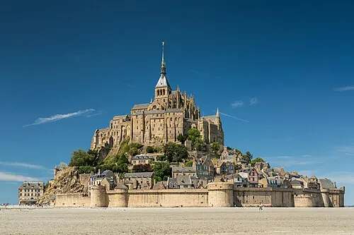 Mont Saint-Michel Island, Manche17 km S
-
 Île des Landes Island, Brittany Region22 km W
-
Baie du Mont-Saint-Michel Natural site, France11 km S
Sources & licences
Data last updated: