- Population
- 66,000
- 66K
- Elevation
- 288 m
- above sea level
- Local time
- UTC+01:00
- Europe/Paris · UTC+01:00
- Places inside
- 91
- listed under Arrondissement of Pamiers
- Airports
- CCF Carcassonne Salvaza Airport51 km
- TLS Toulouse-Blagnac Airport60 km
About Arrondissement of Pamiers
Arrondissement of Pamiers is a municipality. Location: Ariège, Occitanie. Population: 66,000. Elevation: 288 m. The best months to visit are June–September. The nearest airport is Carcassonne Salvaza Airport (51 km). Nearby sights include Douctouire and Bois de la Belène.
Photos of Arrondissement of Pamiers
-
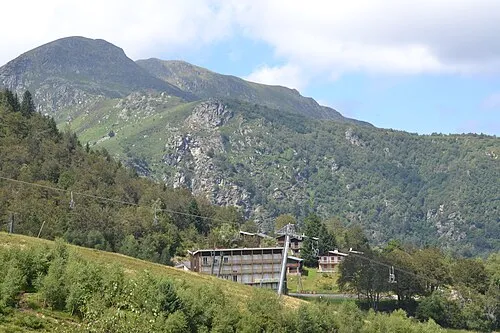
Mont Fourcat Lucas Destrem · CC BY-SA 4.0

Climate of Arrondissement of Pamiers
Best months for sightseeingBest months for sightseeing: June–September.
This month · November
Outside the best season
Day 13° · Night 5° · Rain 64 mm
- Hottest month
- July (day 26°)
- Coldest month
- January (night 2°)
- Wettest month
- May (86 mm)
- Driest month
- July (47 mm)
Bars: average monthly low and high temperature. Below: precipitation. Monthly averages for 1970–2000 at about 18 km resolution, adjusted for elevation. Highlighted months are mild and relatively dry. Source: WorldClim 2.1 (CC BY 4.0).
Show values as a table
| Month | Jan | Feb | Mar | Apr | May | Jun | Jul | Aug | Sep | Oct | Nov | Dec |
|---|---|---|---|---|---|---|---|---|---|---|---|---|
| Average high (°C) | 10° | 11° | 14° | 16° | 19° | 23° | 26° | 26° | 23° | 18° | 13° | 10° |
| Average low (°C) | 2° | 2° | 4° | 6° | 10° | 13° | 15° | 15° | 12° | 9° | 5° | 3° |
| Precipitation (mm) | 68 | 63 | 66 | 80 | 86 | 66 | 47 | 61 | 61 | 69 | 64 | 68 |
Other places to visit in this season: June July August September
How to get to Arrondissement of Pamiers
The nearest airport is Carcassonne Salvaza Airport (CCF), 51 km to the east as the crow flies. For international flights: Toulouse-Blagnac Airport (TLS) (60 km). The nearest large city is Toulouse, 55 km to the north.
Airports
- Carcassonne Salvaza Airport (CCF) Carcassonne 51 kmeast
- Toulouse-Blagnac Airport (TLS) Toulouse/Blagnac 60 kmnorthwest
- Castres Mazamet Airport (DCM) Castres 67 kmnortheast
Nearby large cities
- Toulouse Population: 511.7K 55 kmnorth
- Perpignan Population: 110.7K 111 kmsoutheast
- Girona Population: 100.3K 159 kmsoutheast
- Terrassa Population: 218.5K 177 kmsouth
- Sabadell Population: 211.7K 181 kmsouth
Straight-line distances; road distances are longer. Airport data: OurAirports.
Day trips from Arrondissement of Pamiers
Within 100 km: 165 historic and cultural sites, 1,337 natural sites, 256 lakes, rivers and coasts.
0–25 km33 places
- Montagnes du Plantaurel Mountain 18 kmSW
- Pech de Foix Mountain 21 kmS
- Pic de l'Aspre Mountain 22 kmS
- Cap de Touron Mountain 21 kmS
25–60 km527 places
- Artigue River 58 kmSW
- Pic de Canalbona Mountain 59 kmSW
- Pic dels Tres Comtes Mountain 54 kmSW
- Pic de Baborte Mountain 60 kmSW
60–100 km1,198 places
- Base de loisirs de Bouconne Natural site 69 kmNW
- Forêt de Montaigut Natural site 69 kmNW
- Estany de Travessani Lake 88 kmSW
- Estany de Sant Maurici Lake 84 kmSW
Straight-line distances.
Arrondissement of Pamiers and similar cities
Side by side with cities of similar size in the same country: population, elevation and climate.
| Measure | Arrondissement of Pamiers | Colmar | Bourges | Valence |
|---|---|---|---|---|
| Population | 66K | 65.4K | 68K | 63.9K |
| Elevation | 288 m | 193 m | 144 m | 126 m |
| Summer day (hottest month) | 26° | 25° | 26° | 29° |
| Winter night (coldest month) | 2° | -1° | 1° | 1° |
| Annual rainfall | 799 mm | 654 mm | 717 mm | 888 mm |
| Best months | Jun–Sep | May–Sep | Jun–Sep | May–Sep |
| Distance | — | 705 km | 442 km | 326 km |
Climate values are 1970–2000 monthly averages; straight-line distance.
Places in Arrondissement of Pamiers
91 places- 61 Viviès 150
- 62 Saint-Félix-de-Tournegat 137
- 63 Manses 130
- 64 Sautel 123
- 65 Ilhat 122
- 66 Unzent 122
- 67 Esclagne 119
- 68 Lapenne 119
- 69 Limbrassac 117
- 70 Montségur 116
- 71 Leychert 114
- 72 Nalzen 110
- 73 Troye-d'Ariège 110
- 74 Esplas 104
- 75 Ludiès 102
- 76 Trémoulet 102
- 77 Montbel 99
- 78 Régat 99
- 79 Saint-Michel 92
- 80 Vals 87
- 81 Belloc 84
- 82 Freychenet 82
- 83 Lescousse 82
- 84 Roquefort-les-Cascades 80
- 85 Cazals-des-Baylès 57
- 86 Justiniac 57
- 87 Saint-Julien-de-Gras-Capou 56
- 88 Raissac 49
- 89 Pradettes 43
- 90 Malegoude 36
- 91 Sainte-Foi 29
Bar: population relative to the most populous place in this list.
Nearby attractions & nature
Everything nearby-
Douctouire River, Ariège8 km SE
-
Bois de la Belène Natural site, Ariège9.9 km E
-
Vallée de l'Ariège Natural site, Ariège11 km S
-
Vixiège River, Aude8.7 km NE
-
Lestaud River, Aude9.1 km NE
-
Crieux River, Ariège11 km NW
-
Montagnes du Plantaurel Mountain, Ariège18 km SW
-
Ruisseau le Raunier River, Ariège14 km N
Sources & licences
Data last updated: