Cabrespines
Located in Coubisou, Arrondissement of Rodez Coordinates: 44°34′54″ N 2°43′14″ E
- Elevation
- 422 m
- above sea level
- Local time
- UTC+01:00
- Europe/Paris · UTC+01:00
- Airports
- RDZ Rodez–Aveyron Airport27 km
- AUR Aurillac airport42 km
About Cabrespines
Cabrespines is a village. Location: Coubisou, Arrondissement of Rodez. Elevation: 422 m. The best months to visit are June–September. The nearest airport is Rodez–Aveyron Airport (27 km). Nearby sights include Bonneval Abbey and Plateau de la Viadène.
Photos of Cabrespines
-
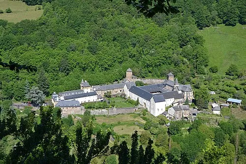
Bonneval Abbey Cd12cd · CC BY-SA 3.0

Climate of Cabrespines
Best months for sightseeingBest months for sightseeing: June–September.
This month · November
A cold month
Day 12° · Night 4° · Rain 60 mm
- Hottest month
- July (day 26°)
- Coldest month
- January (night 0°)
- Wettest month
- October (79 mm)
- Driest month
- July (44 mm)
Bars: average monthly low and high temperature. Below: precipitation. Monthly averages for 1970–2000 at about 18 km resolution, adjusted for elevation. Highlighted months are mild and relatively dry. Source: WorldClim 2.1 (CC BY 4.0).
Show values as a table
| Month | Jan | Feb | Mar | Apr | May | Jun | Jul | Aug | Sep | Oct | Nov | Dec |
|---|---|---|---|---|---|---|---|---|---|---|---|---|
| Average high (°C) | 8° | 9° | 12° | 15° | 19° | 23° | 26° | 26° | 22° | 17° | 12° | 9° |
| Average low (°C) | 0° | 1° | 3° | 5° | 9° | 12° | 14° | 14° | 11° | 8° | 4° | 1° |
| Precipitation (mm) | 61 | 55 | 47 | 61 | 78 | 64 | 44 | 58 | 66 | 79 | 60 | 61 |
Other places to visit in this season: June July August September
How to get to Cabrespines
The nearest airport is Rodez–Aveyron Airport (RDZ), 27 km to the southwest as the crow flies. The nearest large city is Clermont-Ferrand, 136 km to the north.
Airports
- Rodez–Aveyron Airport (RDZ) Rodez/Marcillac 27 kmsouthwest
- Aurillac airport (AUR) Aurillac 42 kmnorthwest
- Brive Souillac airport (BVE) Brive 110 kmnorthwest
Nearby large cities
- Clermont-Ferrand Population: 147.9K 136 kmnorth
- Montpellier Population: 248.3K 142 kmsoutheast
- Toulouse Population: 511.7K 149 kmsouthwest
- Nîmes Population: 148.2K 155 kmsoutheast
- Saint-Etienne Population: 176.3K 162 kmnortheast
Straight-line distances; road distances are longer. Airport data: OurAirports.
Day trips from Cabrespines
Within 100 km: 162 historic and cultural sites, 320 natural sites, 196 lakes, rivers and coasts.
0–25 km62 places
- Lac de Maury Lake 10 kmN
- Puy de l'Arbre Mountain 23 kmNW
- Mont de Roquelaure Mountain 12 kmSE
- Puy de Malavergne Mountain 18 kmSE
25–60 km230 places
- Ancien îlot Gambetta Island 44 kmNW
- Lac de Pareloup Lake 42 kmS
- Lac de Grandval Lake 47 kmNE
- La Falzinde Mountain 55 kmNW
60–100 km386 places
- Étang de Taysse Lake 99 kmNW
- Étang du Prévôt Lake 98 kmNW
- Lac de Montcineyre Lake 99 kmN
- Lac de Madic Lake 90 kmN
Straight-line distances.
Nearby attractions & nature
Everything nearby-
Bonneval Abbey Attraction, Le Cayrol6.2 km E
-
Plateau de la Viadène Natural site, Aveyron5.8 km N
-
Bois de Bonneval Natural site, Aveyron6.5 km E
-
Justic Mountain, Montpeyroux10 km NE
-
Puech de Cambournac Mountain, Montpeyroux12 km NE
-
Puech Maluch Mountain, Laguiole12 km NE
Sources & licences
Data last updated: