Bois d'Arambre
Located in Hautes-Alpes, Provence-Alpes-Côte d'Azur Region Coordinates: 44°26′28″ N 5°44′09″ E
- Elevation
- 1,020 m
- above sea level
- Local time
- UTC+01:00
- Europe/Paris · UTC+01:00
- Airports
- AVN Avignon Caumont airport89 km
- GNB Grenoble Alpes Isère Airport107 km
About Bois d'Arambre
Bois d'Arambre is a natural site. Location: Hautes-Alpes, Provence-Alpes-Côte d'Azur Region. The best months to visit are June–September. The nearest airport is Avignon Caumont airport (89 km). Nearby sights include Rocher d'Arambre and Petit Buech.
Photos of Bois d'Arambre
-
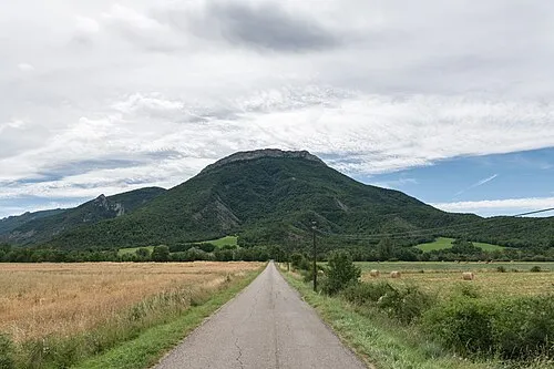
Roc de Longue-Dent Giorgio Galeotti · CC BY-SA 4.0

Climate of Bois d'Arambre
Best months for sightseeingBest months for sightseeing: June–September.
This month · November
A wet month
Day 9° · Night 0° · Rain 107 mm
- Hottest month
- July (day 25°)
- Coldest month
- January (night -4°)
- Wettest month
- November (107 mm)
- Driest month
- July (46 mm)
Bars: average monthly low and high temperature. Below: precipitation. Monthly averages for 1970–2000 at about 18 km resolution, adjusted for elevation. Highlighted months are mild and relatively dry. Source: WorldClim 2.1 (CC BY 4.0).
Show values as a table
| Month | Jan | Feb | Mar | Apr | May | Jun | Jul | Aug | Sep | Oct | Nov | Dec |
|---|---|---|---|---|---|---|---|---|---|---|---|---|
| Average high (°C) | 5° | 7° | 10° | 12° | 17° | 21° | 25° | 25° | 20° | 15° | 9° | 6° |
| Average low (°C) | -4° | -3° | -1° | 2° | 6° | 9° | 12° | 12° | 8° | 5° | 0° | -2° |
| Precipitation (mm) | 75 | 63 | 68 | 76 | 88 | 77 | 46 | 72 | 89 | 102 | 107 | 83 |
Other places to visit in this season: June July August September
How to get to Bois d'Arambre
The nearest airport is Avignon Caumont airport (AVN), 89 km to the southwest as the crow flies. For international flights: Marseille Provence Airport (MRS) (119 km). The nearest large city is Grenoble, 82 km to the north.
Airports
- Avignon Caumont airport (AVN) Avignon 89 kmsouthwest
- Grenoble Alpes Isère Airport (GNB) Grenoble 107 kmnorth
- Marseille Provence Airport (MRS) Marignane, Bouches-du-Rhône 119 kmsouth
Nearby large cities
- Grenoble Population: 158.6K 82 kmnorth
- Aix-en-Provence Population: 146.8K 104 kmsouth
- Nîmes Population: 148.2K 129 kmsouthwest
- Marseille Population: 877.2K 130 kmsouth
- Toulon Population: 168.7K 147 kmsouth
Straight-line distances; road distances are longer. Airport data: OurAirports.
Day trips from Bois d'Arambre
Within 100 km: 138 historic and cultural sites, 1,227 natural sites, 287 lakes, rivers and coasts.
0–25 km104 places
- Quigouret Mountain 21 kmN
- Montagne d'Oule Mountain 11 kmNE
- Tête des Ormans Mountain 23 kmN
- Malaup Mountain 25 kmE
25–60 km472 places
- Clapes River 48 kmE
- Lac du Saulet Lake 44 kmN
- Lake Pierre-Châtel Lake 59 kmN
- Grand Lac des Estaris Lake 58 kmNE
60–100 km1,076 places
- Alba-la-Romaine (Ardèche, France) -- Théâtre gallo-romain Historic site 91 kmW
- Lac Mort Lake 66 kmN
- Île d'Oiselet Island 86 kmSW
- Île de la Piboulette Island 90 kmSW
Straight-line distances.
Nearest towns and villages
-
Serres Village, Arrondissement of Gap2.1 km SW
-
Serres Village, Serres2.3 km SW
-
La Bâtie-Montsaléon Village, Arrondissement of Gap2 km NE
-
La Bâtie-Montsaléon Village, La Bâtie-Montsaléon2 km NE
-
Le Bersac Village, Arrondissement of Gap3.4 km S
-
Sigottier Village, Arrondissement of Gap3.8 km NW
Nearby attractions & nature
Everything nearby-
Rocher d'Arambre Mountain, Serres1.5 km SE
-
Petit Buech River, Hautes-Alpes1.4 km NW
-
Rocher d'Agniel Mountain, Sigottier2.5 km NW
-
Torrent de Blème River, Hautes-Alpes3.3 km SW
-
Château de l'Aigle Mountain, Savournon4.4 km E
-
Roc de Longue-Dent Mountain, Le Saix5.7 km E
-
Bois de Cellas Natural site, Hautes-Alpes4.5 km N
-
Revouaire Mountain, Savournon5.9 km SE
Sources & licences
Data last updated: